Sold2019Metal Classroom Kit of Maps and Charts VintageMetal Classroom Kit of Maps and Charts VintageSee Sold Price
Sold2023Vintage Benefic Press Pull Down Map of AfricaColorful Benefic Press pull down map of Africa with wood and metal frame that would have been used in a school classroom. Map dates between 1960-1965 based on the country names depicted (Republic of CSee Sold Price
Sold2022Vintage Automobilia Items Gas Pump Oil Trays MoreLot full of Automobile misc. items. Oil cans, Steering wheel turning knobs, fuses, Camel tire patch kit tin, keyed gas cap, saw, knifes, Conoco miniature metal gas pump 7 1/2" T, old razors, old mapsSee Sold Price
Sold2022AJ Nystrom 2-Sided Chalkboard School Map, US & WorldLarge AJ Nystrom Roll Up 2 Sided Chalkboard Classroom Map Chart, US & World. Wonderful chart has maps of the United States and the World outlined in yellow on a black chalkboard backing. From the RoyaSee Sold Price
Sold2021Group of 5 vintage classroom mapsMaps are 40 inches wide. Plastic coated. Duo graphic series, Boones ProjectionSee Sold Price
Sold2016Vintage Metal Kit Toy PlaneThis Lot Includes a Vintage Ca. 1950's Steel Kit Plane. This would be a Great Piece to add to your Collection. This Piece Measures 9" Long x 12" Wingspan.See Sold Price
Sold2024World War 2. Planned expansion of Japanese Empire 1959 old vintage map chartCAPTION PRINTED BELOW PICTURE: 'The War with Japan - Contemplated Expansion of Japanese Empire' DATE PRINTED: 1959 IMAGE SIZE: Approx 25.0 x 32.0cm, 9.75 x 12.75 inches (Large) TYPE: Antique colour miSee Sold Price
Sold2016Large Collection of Assorted Maps and Navigation ChartsLarge Collection of Assorted Maps and Navigation Charts, vintage and new, good condition.See Sold Price
Sold2019Lot of School Classroom Pull Down Maps and Charts NystrLot of School Classroom Pull Down Maps and Charts NystromSee Sold Price
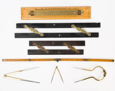
Sold2021Antique & Vintage Marine Map Chart AccessoriesA group of six very good marine map chart accessories, consisting of: two antique ebony & brass parallel rules - the 12" rule stamped THREADWELL LONDON, the 18" rule with minor chips, a 15" antique brSee Sold Price
Sold2021Set 8 of School Charts - Texas History and ResourcesSet 8 of Vintage School Charts Maps - Texas History and Resources36 in tall x 45 x 1 - Denoyer - Geppert of Chicago / J. L Clark & Lewis W. NewtonSee Sold Price
Sold2023Vintage Metal Picnic KitVintage metal double handle picnic kit with denim and red bandana décor, has all original contents & parts, 20"TSee Sold Price
Sold2023NMC National Motor Co O scale white metal vintage vehicle kitsNMC National Motor Co O scale white metal vintage vehicle kits to include 1910 Ford model T, 1912 Depot Hack and two 1911 Ford Model T T Torpedo, all complete and untouched in original boxes.See Sold Price
Sold2023L'Africa. DE ROSSI / SANSON 1677 old antique vintage map plan chartTITLE/CONTENT OF MAP: L'Africa [Africa] DATE PRINTED: 1677 IMAGE SIZE: Approx 42.5 x 57.0cm, 16.75 x 22.25 inches (Large) TYPE: Antique 17th century folio atlas map CONDITION: Good; suitable for framiSee Sold Price
Sold2024L'Europa. Europe. DE ROSSI 1677 old antique vintage map plan chartTITLE/CONTENT OF MAP: L'Europa [Europe] DATE PRINTED: 1677 IMAGE SIZE: Approx 44.0 x 56.5cm, 17.25 x 22.25 inches (Large) TYPE: Antique 17th century folio atlas map CONDITION: Good; suitable for framiSee Sold Price
Sold2023L'Europe. Europe. BONNE 1780 old antique vintage map plan chartTITLE/CONTENT OF MAP: 'L'Europe' A map of Europe DATE PRINTED: 1780 IMAGE SIZE: Approx 23.0 x 34.0cm, 9 x 13.5 inches (Large); Please note that this is a folding map. TYPE: Antique copperplate engraveSee Sold Price
2022Havana. Cuba 1885 old antique vintage map plan chartTITLE/CONTENT OF MAP: 'Havana' DATE PRINTED: 1885 IMAGE SIZE: Approx 22.5 x 29.0cm, 8.75 x 11.25 inches (Large); Please note that this is a folding map. TYPE: Antique colour map; Scale 1:14,000 CONDITSee Sold Price
Sold2023HOLY ROMAN EMPIRE. Europe in 1360 1902 old antique vintage map plan chartTITLE/CONTENT OF MAP: 'Europe in 1360' DATE PRINTED: 1902 IMAGE SIZE: Approx 25.0 x 33.5cm, 10 x 13.25 inches (Large) TYPE: Antique colour map. This map was published in 1902 but it may depict an earlSee Sold Price
Sold2023South America. Second World War 1942 old vintage map plan chartTitle: South America. Second World War 1942 old vintage map plan chart Description: South America' by George Philip & Son (1942). Vintage colour map, 27.5 x 22.0cm, 10.75 x 8.5 inches Product InformatSee Sold Price
Sold2023South America. Second World War 1942 old vintage map plan chartTitle: South America. Second World War 1942 old vintage map plan chart Description: South America' by George Philip & Son (1942). Vintage colour map, 27.5 x 22.0cm, 10.75 x 8.5 inches Product InformatSee Sold Price
Sold2024Europe by Arrowsmith & Lewis 1812 old antique vintage map plan chartTITLE/CONTENT OF MAP: 'Europe' DATE PRINTED: 1812 IMAGE SIZE: Approx 25.0 x 20.0cm, 9.75 x 8 inches (Medium) TYPE: Antique steel engraved map CONDITION: Good; suitable for framing. Please check the scSee Sold Price
Sold2024Pacific Ocean. BARTHOLOMEW 1949 old vintage map plan chartTITLE/CONTENT OF MAP: 'Pacific Ocean' DATE PRINTED: 1949 IMAGE SIZE: Approx 18.5 x 22.5cm, 7.25 x 8.75 inches (Medium); Please note that this is a folding map. TYPE: Vintage colour atlas map CONDITIONSee Sold Price
Sold2022Western division of Cuba 1885 old antique vintage map plan chartTITLE/CONTENT OF MAP: 'Western division of Cuba' DATE PRINTED: 1885 IMAGE SIZE: Approx 13.0 x 11.5cm, 5 x 4.5 inches (Small) TYPE: Antique wood-engraved map; Scale 1:6,000,000 CONDITION: Good; suitablSee Sold Price
Sold2023AFRICA. Africa. Britannica 9th edition 1898 old antique vintage map plan chartTITLE/CONTENT OF MAP: 'Africa' DATE PRINTED: 1898 IMAGE SIZE: Approx 26.0 x 32.5cm, 10.25 x 12.75 inches (Large); Please note that this is a folding map. TYPE: Antique coloured map CONDITION: Good; suSee Sold Price
Featured1 day LeftJasper52BARBADOS. Vintage map. West Indies Caribbean 1923 old antique plan chart$50


![L'Africa. DE ROSSI / SANSON 1677 old antique vintage map plan chart: TITLE/CONTENT OF MAP: L'Africa [Africa] DATE PRINTED: 1677 IMAGE SIZE: Approx 42.5 x 57.0cm, 16.75 x 22.25 inches (Large) TYPE: Antique 17th century folio atlas map CONDITION: Good; suitable for frami](https://p1.liveauctioneers.com/5584/308981/165185503_1_x.jpg?height=310&quality=70&version=1699996168)
![L'Europa. Europe. DE ROSSI 1677 old antique vintage map plan chart: TITLE/CONTENT OF MAP: L'Europa [Europe] DATE PRINTED: 1677 IMAGE SIZE: Approx 44.0 x 56.5cm, 17.25 x 22.25 inches (Large) TYPE: Antique 17th century folio atlas map CONDITION: Good; suitable for frami](https://p1.liveauctioneers.com/5584/322790/173578184_1_x.jpg?height=310&quality=70&version=1710881198)


