Sold2018Mitchell: Antique Map of Utah and Nevada,1870Title/Content of Map: 1870 Mitchell Map of Utah and Nevada -- County Map of Utah and Nevada Date Printed: 1870 Philadelphia Cartographer: S Mitchell Size: 10.6 X 13.5 in. Handsome county map of Utah aSee Sold Price
Sold20231877 Mitchell Map of Utah and Nevada [verso] Arizona and New Mexico -- County Map of of Utah andTitle: 1877 Mitchell Map of Utah and Nevada [verso] Arizona and New Mexico -- County Map of of Utah and Nevada [verso] County Map Arizona and New Mexico Cartographer: S Mitchell Year / Place: 1877 PhiSee Sold Price
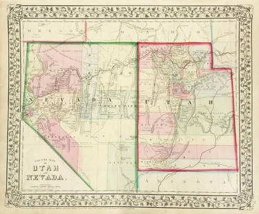
Sold20191876 Mitchell Map of Utah and Nevada [verso] ArizonaTitle/Content of Map: 1876 Mitchell Map of Utah and Nevada [verso] Arizona and New Mexico -- County Map of of Utah and Nevada [verso] County Map Arizona and New Mexico Date: 1876 Philadelphia CartograSee Sold Price
Sold2017Mitchell: Antique County Map of Utah & Nevada, 1870[Utah, Nevada]. N. p: S. Augustus Mitchell, 1870s. The map was drawn and engraved by W. H. Gamble of Philadelphia. Coloured map. Approximately 11-3/4 x 14-/4 inches image area, one sheet, matted. FineSee Sold Price
Sold2019Mitchell: County Map of Utah & NevadaMap Title: County Map of Utah and NevadaCartographer: S. A. Mitchell Place/Date: Philadelphia / 1870 Size: 14" x 11 5/8" Condition: full color; light overall age toning The beautifully detailed and coSee Sold Price
Sold2022Nevada & Utah 1880Title/Content of Map: Nevada & Utah 1880 Date Printed: 1880 Material/Medium: paper Size: folio, 23x 15 inches Additional Info: Hand colored county & township map of Utah & Nevada by Mitchell. Map measSee Sold Price
Sold2020Rare map of Eureka Mining District, NevadaHeading: (Nevada) Author: Hall, Leon M. Title: Compiled Map Showing Properties of the Eureka Mining District, Eureka County, Nevada Place Published: Eureka County, Nevada Publisher: Date PublisheSee Sold Price
Sold2023Northeastern Nevada Ephemera Collection [144496]The primary piece is Sparks & Harrell Co. general merchandise, San Jacinto. Very rare location!!! Sparks is no other than Governor Sparks. Elko includes Elko County Telephone and Telegraph (1919), RexSee Sold Price
Sold2018ELKO EARED POINT INDIAN ARTIFACT ARROWHEADTHIS BEAUTIFUL NATIVE AMERICAN INDIAN ARTIFACT IS 1&5/16 INCHES LONG. IT IS FROM WASHOE COUNTY NEVADA. IT WILL MAKE A GREAT ADDITION TO YOUR COLLECTION! KEY WORDS: NATIVE AMERICAN INDIAN ARTIFACT ARTISee Sold Price
Sold2018ELKO CORNER NOTCH INDIAN ARTIFACT ARROWHEADTHIS BEAUTIFUL NATIVE AMERICAN INDIAN ARTIFACT IS 1&7/16 INCHES LONG. IT IS FROM WASHOE COUNTY NEVADA. IT WILL MAKE A GREAT ADDITION TO YOUR COLLECTION! KEY WORDS: NATIVE AMERICAN INDIAN ARTIFACT ARTISee Sold Price
Sold2018ELKO SPLIT STEM INDIAN ARTIFACT ARROWHEADTHIS BEAUTIFUL NATIVE AMERICAN INDIAN ARTIFACT IS 1&5/8 INCHES LONG. IT IS FROM WASHOE COUNTY NEVADA. IT WILL MAKE A GREAT ADDITION TO YOUR COLLECTION! KEY WORDS: NATIVE AMERICAN INDIAN ARTIFACT ARTIFSee Sold Price
Sold2016George Cram: New Railroad of California & Nevada 1882Map: New Railroad and County Map of Northern California and Nevada Maker: George Franklin Cram Publishing: Chicago Date: 1882 Size: 11.5 x 19.3 inches Map with counties separately colored (15 in NV anSee Sold Price
Sold2016Map of Nevada, 1895Original engraving from Atlas of the World by Rand McNally, 1895. Map includes counties, geographical landmarks, streets and population data. Dimensions: 21 1/4" x 14" No Reserve Buyer pays shipping.See Sold Price
Sold2020Real estate map of Berkeley Woods with ms. noted, 1917Heading: (California - Contra Costa County) Author: Title: Map of Berkeley Woods Contra Costa County, Cal. Scale 1 in. = 100 feet Place Published: [Berkeley, CA] Publisher: Date Published:See Sold Price
Sold2021Early 2-pg map of California w/Nevada, 1883Nice early double-page map of California from one of the earliest Cram atlases. Also shows most of Nevada. Shows only seven counties in southern part of the state below the 36th parallel (there are noSee Sold Price
Sold2022Map of the State California and NevadaMap of the State California and Nevada Dimensions: 10 x 13" Condition Report Good. Center fold as issued. Text on verso. Subject References: BL1830See Sold Price
Sold2020Map of California, Oregon Utah Nevada +Map of California, Oregon, Idaho, Utah, Nevada, Arizona and Washington PLUS Mexico and Central America on verso Two maps on one sheet. (back to back). Hand colored.See Sold Price
Sold2017McNally: Map of Nevada, 1898Detached leaf from the Indexed Atlas of the World. Colored print, each county a different color, with lots of detail regarding mountains, rivers, etc. Written information about Alaska on the verso[NevSee Sold Price
Sold20211887 Map of NevadaAuthor: Watson Title: 1887 Map of Nevada Medium: Ink on Paper Dimensions: 11.5"X16.5" Map of Nevada, dated 1887 engraved for Watson's General Atlas. Color coded for counties. Insets of mining territorSee Sold Price
Sold2022TWO SIEGFRIED & ROY HONORARY DEPUTY SHERIFF BADGES FOR CLARK COUNTY, NEVADATWO SIEGFRIED & ROY HONORARY DEPUTY SHERIFF BADGES FOR CLARK COUNTY, NEVADA The gold tone badges stamped 'Roy Horn' and 'Siegfried Fischbacher', each housed in a black leather wallet accompanied by aSee Sold Price
Sold2022Ms. map of Potrero district SF 1865Heading: -1865 Author: Title: Map of Potrero Nuevo, San Francisco. May, 1865 Place Published: San Francisco Publisher: Date Published: 1865 Description: Ink manuscript map on arSee Sold Price
Sold2022Large ms. map from Mission to Castro SF c1864Heading: -1864 Author: Title: Map Shewing the Subdivision of the R.J. Tiffany and B.D. Dean Tract. San Francisco Cal. Scale 100 Feet to One Inch Place Published: San Francisco Publisher: Date PuSee Sold Price
Sold2022Ms. map Outer Mission S.F. 1864Heading: -1864 Author: Potter, George C. Title: Manuscript map of the portion of San Francisco roughly bounded by Mission, 29th, Guerrero, and 26th streets Place Published: San Francisco Publisher:See Sold Price
Sold2022Ms. map Outer Mission S.F. c.1880Heading: -1880 Author: Title: Manuscript map of the portion of San Francisco roughly bounded by Mission, 29th, Guerrero, and 25th streets Place Published: San Francisco Publisher: Date PublishedSee Sold Price
3 days LeftHeartland Artifact Auctions IncStunning Agate Elko Eared, 2x COA, Rogers / Michael, found in Churchill County Nevada, 1920s-1960'$1,025(6 bids)
Featured5 days LeftJasper521878 Mitchell Map of Virginia and West Virginia [verso] New Jersey, Maryland and Delaware -- County$45
384 Lots AwayPotter & Potter AuctionsMcCARTY, Lea (1905 – 1960). Sonoma County / Its Highlights ...$100(1 bid)
6 days LeftThomaston Place Auction GalleriesEARLY 17TH C. ELIZABETHAN ENGRAVED MAP OF CORNWALL BY WILLIAM KIP AFTER WILLIAM SAXTON$150
2 days LeftRapid Estate Liquidators and Auction GalleryFramed Collection Engravings & A Map From The Excursions In The County Of Sussex Published In 1822$5
385 Lots AwayPotter & Potter AuctionsLINDGREN, Hjalmer “Jolly” (1895–1952). A Hysterical Map of ...$150(1 bid)
1 day LeftAlbion AuctionsGentleman's Magazine 1778 Canal Map. Basingstoke, River Wey, Surrey$5(1 bid)


![1877 Mitchell Map of Utah and Nevada [verso] Arizona and New Mexico -- County Map of of Utah and: Title: 1877 Mitchell Map of Utah and Nevada [verso] Arizona and New Mexico -- County Map of of Utah and Nevada [verso] County Map Arizona and New Mexico Cartographer: S Mitchell Year / Place: 1877 Phi](https://p1.liveauctioneers.com/5584/293457/155766077_1_x.jpg?height=310&quality=70&version=1687903812)
![1876 Mitchell Map of Utah and Nevada [verso] Arizona: Title/Content of Map: 1876 Mitchell Map of Utah and Nevada [verso] Arizona and New Mexico -- County Map of of Utah and Nevada [verso] County Map Arizona and New Mexico Date: 1876 Philadelphia Cartogra](https://p1.liveauctioneers.com/5584/137769/69881187_1_x.jpg?height=310&quality=70&version=1552435690)
![Mitchell: Antique County Map of Utah & Nevada, 1870: [Utah, Nevada]. N. p: S. Augustus Mitchell, 1870s. The map was drawn and engraved by W. H. Gamble of Philadelphia. Coloured map. Approximately 11-3/4 x 14-/4 inches image area, one sheet, matted. Fine](https://p1.liveauctioneers.com/5584/107399/55057774_1_x.jpg?height=310&quality=70&version=1501794677)


![Northeastern Nevada Ephemera Collection [144496]: The primary piece is Sparks & Harrell Co. general merchandise, San Jacinto. Very rare location!!! Sparks is no other than Governor Sparks. Elko includes Elko County Telephone and Telegraph (1919), Rex](https://p1.liveauctioneers.com/2699/282572/149010614_1_x.jpg?height=310&quality=70&version=1679417398)


![Real estate map of Berkeley Woods with ms. noted, 1917: Heading: (California - Contra Costa County) Author: Title: Map of Berkeley Woods Contra Costa County, Cal. Scale 1 in. = 100 feet Place Published: [Berkeley, CA] Publisher: Date Published:](https://p1.liveauctioneers.com/642/174090/87617742_1_x.jpg?height=310&quality=70&version=1595023143)


![1878 Mitchell Map of Virginia and West Virginia [verso] New Jersey, Maryland and Delaware -- County (1 of 2)](https://p1.liveauctioneers.com/5584/329422/177662152_1_x.jpg?height=282&quality=70&version=1715717898)


