Sold2023Excellent 1860 map of Baltimore by Samuel A. Mitchell, Jr.Nice example of Samuel Augustus Mitchell Jr’s map of Baltimore with the vivid outline hand coloring that sets this edition off from other editions. Shows wonderful detail at the street level, inSee Sold Price
Sold2018Mitchell: Antique Map of Indiana and Ohio, 1860Title/Content of Map: 1860 Mitchell Map of Indiana and Ohio -- County Map of Ohio and Indiana Date Printed: 1860 Philadelphia Cartographer: S Mithchell Size: 10.5 x 13.2 A very nice county map of OhioSee Sold Price
Sold20191860 Mitchell Map of Baltimore -- Plan of BaltimoreTitle: 1860 Mitchell Map of Baltimore -- Plan of Baltimore Date: 1860, Philadelphia Cartographer: S Mitchell Size: 9 X 11.2 in. Additional Information: A very nice map of Baltimore, identifying the vaSee Sold Price
Sold2018Mitchell: Antique Map of Maine, 1860Title/Content of Map: 1860 Mitchell Map of Maine -- County Map of the State of Maine Date Printed: 1860, Philadelphia Cartographer: S Mitchell Size: 13.2 X 10.5 in. A very nice pastel color coded counSee Sold Price
Sold2023Toyokuni III Woodblock - Steep Climb to SekisonArtist: Toyokuni III, Utagawa, 1786-1875 Title: The Steep Climb to Sekison Daigongen Shrine Date: 1860 Medium: Japanese woodblock print Image Size: 14 1/2 x 9 3/4 inches NoSee Sold Price
Sold20211860 Mexico, Central Amer. - MitchellA fine example of Mitchell's 1860 map of Mexico, Central America, and the West Indies from the Mitchell New Universal Atlas of 1866. Depicts the region in considerable detail with notations regardingSee Sold Price
Sold2018Hand Colored Map of the World, Willem BlaeuWillem Blaeu, (Dutch, 1571-1638) "Nova Totius Terrarum Orbis Geograhica ac Hydrographica" originally published 1606 Nice old color example of Blaeu's classic world map Approx. 19.5" x 25.5" (unframed)See Sold Price
Sold2017Mitchell: Map of World in Hemispheres, 18601860 Mitchell World in Hemispheres. 11 X 13 inches. Very desirable and antique map of the world in a stunning layout showing seven separate views with the longest rivers and their tributaries in eachSee Sold Price
Sold20221942 Lionel US Navy Ships Binnacle New Old StockThis is a very nice example of a World War 2 era United States Navy ships binnacle. This piece was made by the Lionel Corporation and is dated 1942. The binnacle is housed inside the gray-painted domeSee Sold Price
Sold2024WW2 US Navy / Marines Mark 2 Combat KnifeThis is a very nice example of a World War 2 era KA-BAR Mark 2 combat knife. The sheath is stamped USN MK2 on one side, the other side NORD – 6581 B.M. Co 7 vp. The knife is stamped KA-BAR USMC, meaSee Sold Price
Sold2022Nice 1860 map of Maine with full hand coloringVery nice vintage map of Maine with original hand coloring by county. Features signature floral border that makes Mitchell maps stand apart. Railroads clearly delineated and named. Shows coastal featuSee Sold Price
Sold2019Nice 1860 map of AfricaMap of Africa, Showing Its Most Recent Discoveries (with Inset of the Island of St. Helena). Full hand coloring. 1860 date; from 1866 Mitchell New General Atlas. Good impression. Foxed heavily in margSee Sold Price
Sold2017Mitchell: Antique Map of Florida, 1848Florida (insets of Pensacola, Tallahassee and Harbour of St. Augustine) S. Augustus Mitchell, 1848. Nice example of an early edition of Mitchell's map of Florida, with insets of Pensacola, TallahasseeSee Sold Price
Sold2021Colton’s Map of the World - 1855Nice example of Colton's Map of the World from the first edition of Colton’s Atlas of the World. Shows the routes of numerous 18th and 19th Century explorers, including Cook, Furneaux, Vancouver, thSee Sold Price
Sold20211860 Mitchell Map of New Orleans -- Plan of New OrleansTitle: 1860 Mitchell Map of New Orleans -- Plan of New Orleans Cartographer: S Mitchell Year / Place: 1860, Philadelphia Map Dimension (in.): 9.2 X 11 in. This is a very an attractive map of the CrescSee Sold Price
Sold20191860 Mitchell Map of New Orleans -- Plan of New OrleansTitle: 1860 Mitchell Map of New Orleans -- Plan of New Orleans Date: 1860, Philadelphia Cartographer: S Mitchell Size: 9.2 x 10.9 in. Additional Information: An excellent map of the Crescent City, shoSee Sold Price
Sold20211860 Mitchell Map of New Orleans -- Plan of New OrleansTitle: 1860 Mitchell Map of New Orleans -- Plan of New Orleans Cartographer: S Mitchell Year / Place: 1860, Philadelphia Map Dimension (in.): 9.2 x 10.9 in. This is an excellent map of the Crescent CiSee Sold Price
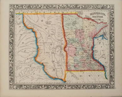
Sold20201860 Mitchell Map of Minnesota and the DakotasTitle/Content of Map: 1860 Mitchell Map of Minnesota and the Dakotas --Minnesota and Dacotah Date: 1860, Philadelphia Cartographer: S Mitchell Size: 10.6 X 13.3 in. This is a rather nice map of MinnesSee Sold Price
Sold20191860 Mitchell Map of Florida and South Carolina --Title/Content of Map: 1860 Mitchell Map of Florida and South Carolina -- County Map Of Florida [on sheet with] Map Of South Carolina Date: 1860, PhiladelphiaCartographer: S Mitchell Size: 10.8 x 13.2See Sold Price
Sold2017Mitchell: Antique Map of New Orleans, 1860Title/Content of Map: 1860 Mitchell Map of New Orleans -- Plan of New Orleans Date Printed: 1860, Philadelphia Cartographer: S Mitchell Size: 9.2 x 10.9 in. An excellent map of the Crescent City, showSee Sold Price
Sold2018Mitchell: Antique Map of New Orleans, 1860Title/Content of Map: 1860 Mitchell Map of New Orleans -- Plan of New Orleans Date Printed: 1860, Philadelphia Cartographer: S Mitchell Size: 9.2 x 10.9 in. An excellent map of the Crescent City, showSee Sold Price
Sold2023Old Christmas Feather Tree Candle ClipsA Nice large lot of Pre-World War 2 tin Christmas tree candle clips, some very nice examples,See Sold Price
Sold2023Old Christmas Feather Tree Candle ClipsA Nice large lot of Pre-World War 2 tin Christmas tree candle clips, some very nice examples,See Sold Price
Sold20224 Native American Adena Points.4 Native American Adena Points. Nice Examples. c. 1,000-2,000 BC. In Plastic Box. Condition: Generally GoodDimensions: L-1.9". Box-5.5" x 3.5". Provenance: From a Private Collection of a Gentleman & BSee Sold Price
1 day LeftSTAIRLockwood de Forest and The Ahmedabad Wood Carving Company, Indian Teakwood Model of the Windows in$2,500
4 days LeftSouth Jersey Auction by Babington Auction IncLrg. world map decorated trunk style coffee table$100
Oct 05North American Artifact AuctionsPre-Columbian Mayan Polychrome Pottery Plate w/ Zoomorphic Painting 600-900 CE$85(10 bids)
Oct 18Dan Morphy AuctionsDOUBLE SIDED CLEVELAND NEON CLOCK ADVERTISING "MURPHY'S FINE FOOD"$700(3 bids)


![1860 Mitchell Map of Florida and South Carolina --: Title/Content of Map: 1860 Mitchell Map of Florida and South Carolina -- County Map Of Florida [on sheet with] Map Of South Carolina Date: 1860, PhiladelphiaCartographer: S Mitchell Size: 10.8 x 13.2](https://p1.liveauctioneers.com/5584/144953/73284299_1_x.jpg?height=310&quality=70&version=1562102885)


