Sold2024NORTH AFRICA. Morocco Algeria Tunis Tunisia Egypt. Cairo. BARTHOLOMEW 1901 mapTITLE/CONTENT OF MAP: 'Morocco, Algeria, & Tunis; Upper & Lower Egypt; Inset map of Cairo' DATE PRINTED: 1901 IMAGE SIZE: Approx 33.5 x 44.0cm, 13.25 x 17.25 inches (Large); Please note that this is aSee Sold Price
Sold2023NORTH AFRICA. Morocco Algeria Tunis Tunisia Egypt. Cairo. BARTHOLOMEW 1901 mapTITLE/CONTENT OF MAP: 'Morocco, Algeria, & Tunis; Upper & Lower Egypt; Inset map of Cairo' DATE PRINTED: 1901 IMAGE SIZE: Approx 33.5 x 44.0cm, 13.25 x 17.25 inches (Large); Please note that this is aSee Sold Price
Sold2023NORTH AFRICA BARBARY. Tripoli Libya Egypt coast Alexandria Tobruk. SDUK 1874 mapTITLE/CONTENT OF MAP: 'NORTH AFRICA OR BARBARY, V., PARTS OF TRIPOLI AND EGYPT' DATE PRINTED: 1874 IMAGE SIZE: Approx 34.0 x 42.5cm, 13.25 x 16.75 inches (Large) TYPE: Antique steel engraved map withSee Sold Price
Sold2020Barbary coat. North west Africa. Morocco, Tunisia,Title: Barbary coat. North west Africa. Morocco, Tunisia, Algeria and Libya.. Date/Period: 1762 - 1771 Materials: Copperplate engraved Size: 20”x 14 1/2”. Barbary coast, shows North African countrSee Sold Price
Sold20241837. Map of Barbary Coast. Northwest Africa. Morocco, Algeria, Libya and Tunisia. By A. PerrotTitle: 1837. Map of Barbary Coast. Northwest Africa. Morocco, Algeria, Libya and Tunisia. By A. Perrot Date/Period: 1837 Materials: Hand-colored steel engraving Size: 7 x 10 3/4” This is a map oSee Sold Price
Sold2022NORTH AFRICA COSTUME. Arab/Berber man & woman in 17C dress. Barbary. MALLET 1683TITLE OF THE PRINT: 'Habitans de Barbarie' (De L'Afrique) DATE PRINTED: 1683 IMAGE SIZE: Approx Overall page size 13 x 21cm approximately (5 x 8 inches); image size 10.5 x 14.5cm approximately (4 x 5.See Sold Price
Sold2024NORTH EAST AFRICA. Libya Egypt Sudan Ethiopia Ubangi-Shari Chad 1952 old mapCAPTION PRINTED BELOW PICTURE: 'Africa, North-East' DATE PRINTED: 1952 IMAGE SIZE: Approx 34.0 x 44.0cm, 13.5 x 17.25 inches (Large); Please note that this is a folding map. TYPE: Vintage colour map;See Sold Price
Sold2023NORTH EAST AFRICA. Libya Egypt Sudan Ethiopia Ubangi-Shari Chad 1952 old mapTITLE/CONTENT OF MAP: 'Africa, North-East' DATE PRINTED: 1952 IMAGE SIZE: Approx 34.0 x 44.0cm, 13.5 x 17.25 inches (Large); Please note that this is a folding map. TYPE: Vintage colour map; Scale 1:1See Sold Price
Sold20181714 Moll Map of North Africa -- The East Part ofTitle/Content of Map: 1714 Moll Map of North Africa -- The East Part of Barbary Containing Tunis, Tripoli. Barca, Egypt, Nubia, Part of Biledul… Date: 1714 c., London Cartographer: H Moll Size: 6.9See Sold Price
Sold2018Sanson: North Africa / Patriarchate of Alexandria, 1730Partriarchatus Alexandrini Geographica descriptio The later Covens & Mortier edition of Sanson's map of the Patriarchate of Alexandria encompassing Libya and Egypt, with great detail and many place naSee Sold Price
Sold20231892 Black Map of Africa [on Separate Sheet] Morocco, Algeria to Tunisia [on Separate Sheet] EgyptTitle: 1892 Black Map of Africa [on Separate Sheet] Morocco, Algeria to Tunisia [on Separate Sheet] Egypt Cartographer: A&C Black Year / Place: 1892, Edinburgh Map Dimension (in.): 21.3 X 16.8 in. LarSee Sold Price
Sold2019SDUK: North Africa in 5 sheetsMap Title: North Africa or Barbary I – V Cartographer: Baldwin & Cradock, Society for the Diffusion of Useful Knowledge Place/Date: London / 1836/1852 Size: 15 1/4" x 12 1/2" Condition: b&w; overallSee Sold Price
Sold20211840 SDUK Map of Morocco -- Northern Africa or BarbaryTitle: 1840 SDUK Map of Morocco -- Northern Africa or Barbary I Marocco Cartographer: SDUK Year / Place: 1840, London Map Dimension (in.): 12.6 x 15.4 in This is very nice and superbly detailed map ofSee Sold Price
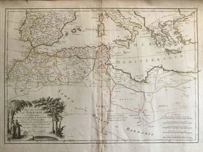
Sold2016Jean-Baptiste Louis Clouet: North Africa 1787Map: Barbary Coast, North Africa Maker: Jean-Baptiste Louis Clouet From Géographie Moderne Origin: Paris Date: 1787 Medium: Engraving hand-colored at publication Sheet Size: 19.75 x 26.75 inches No RSee Sold Price
Sold2016Bowen map of North Africa 1747Heading: (Map) Author: Bowen, Emanuel Title: A New & Accurate Map of the Western Parts of Barbary [on sheet with] A New & Accurate Map of the Eastern Parts of Barbary Place Published: London PublisherSee Sold Price
Sold20171837 PIRATES & Piracy Barbary States EGYPT Carthage1837 PIRATES & Piracy Barbary States EGYPT Carthage Africa Moors Morocco Bishop Michael Russell was a 19th-century historian who was well-versed in a variety of subjects, including Biblical and Holy LSee Sold Price
Sold2024GREECE & BALKANS. Albania Bulgaria Serbia Croatia Bosnia Aegean. MALLET 1683 mapTITLE OF THE MAP: 'De la Turquie Meridionale en Europe' (De L'Europe) The map extends from Greece northwards to the Danube. Shows Romania. Serbia. etc. DATE PRINTED: 1683 IMAGE SIZE: Approx Overall paSee Sold Price
Sold2019Beni Mguild Pile RugFirst quarter 20th century, 380 x 170 cm, North Africa, Morocco, Middle Atlas Rather than a monochrome surface, the open field of this large Berber carpet presents the sum of various shades of crimsonSee Sold Price
Sold2021Rare Fossilized Rugops Raptor Killing Claw - Large!North Africa, Morocco, Kem Kem Formation, Middle Cretaceous Period, ca. 98 to 93 million years ago. An amazing, fossilized raptor claw, possibly from the Rugops genus of dinosaurs, a rare species thatSee Sold Price
Sold2020THEODORE GUDIN'S 19TH CENTURY PAINTINGTheodore Gudin was a French 19th Century painter who was born in 1802. Theodore Gudin is featured in Sotheby's Annual Orientalist Sale, Features Paintings Representing North Africa, Egypt, Arabia, theSee Sold Price
Sold2022Rare Fossilized Ammonite Open Coil HeteromorphNorth Africa, Morocco, Mid-Cretaceous period, ca. 112 to 99.6 million years ago. A superb and aesthetically pleasing fossilized heteromorph ammonite, that was fully excavated- apart from some of the lSee Sold Price
Sold20215 Large Islamic Egyptian Fustat Glass BeadsNorth Africa, Egypt, Fustat, Islamic culture, ca. 7th to 11th century CE. A wonderful ensemble of 5 sizeable glass beads, each presenting a barrel form and formed using the mosaic glass technique. EacSee Sold Price
Sold20233rd C. Roman Byzantine Tile - Face w/ Halo, TL TestedBack at auction due to non-paying bidder... Late Roman / Byzantine Empire, North Africa, Tunisia, Carthage, ca. 3rd to 4th century CE. A lovely mold-made terracotta tile in low relief with a face withSee Sold Price
20233rd C. Roman Byzantine Tile - Face w/ Halo, TL TestedLate Roman / Byzantine Empire, North Africa, Tunisia, Carthage, ca. 3rd to 4th century CE. A lovely mold-made terracotta tile in low relief with a face within a sunburst / halo, an early Christian repSee Sold Price
Featured5 days LeftJasper521797 Mallet Map of the Northern Constallations and Milky Way -- La Voye Laictee Pole Arctique$110
May 291st Source ConsignmentVintage 1960s Oriental Scenes Poster by Editions Rossignol, Framed, a Pair$200
May 30NY Elizabeth ANTIQUE MAP-ILLUSTRATED FLORAL ILLUSTRATION 1761 NEW DICTIONARY OF TRADE AND COMMERCE R. ROTH$50
3 days LeftUkiyoe Gallery Japanese Woodblock PrintsYoshida Hiroshi: Soshu 1940 JIZURI Woodblock$2,500(5 bids)
3 days LeftUkiyoe Gallery Japanese Woodblock PrintsHiroshi Yoshida - Evening Nara 1st Ed JIZURI Woodblock$450(3 bids)
3 days LeftLeonard Auction, a division of The Leonard CompanyAfrican Ethnographic Object Assortment$300


![1892 Black Map of Africa [on Separate Sheet] Morocco, Algeria to Tunisia [on Separate Sheet] Egypt: Title: 1892 Black Map of Africa [on Separate Sheet] Morocco, Algeria to Tunisia [on Separate Sheet] Egypt Cartographer: A&C Black Year / Place: 1892, Edinburgh Map Dimension (in.): 21.3 X 16.8 in. Lar](https://p1.liveauctioneers.com/5584/279105/146836151_1_x.jpg?height=310&quality=70&version=1677020518)


![Bowen map of North Africa 1747: Heading: (Map) Author: Bowen, Emanuel Title: A New & Accurate Map of the Western Parts of Barbary [on sheet with] A New & Accurate Map of the Eastern Parts of Barbary Place Published: London Publisher](https://p1.liveauctioneers.com/642/86438/44449747_1_x.jpg?height=310&quality=70&version=1458591928)


