Sold2016Rare little 1820 American atlasHeading: Author: Potter, Peregrine Title: [Atlas of the World] Place Published: Poughkeepsie, NY Publisher: Date Published: [1820] Description: With 6 (of 7) double-page engraveSee Sold Price
Sold20211790 Geography Dictionary World MAPS Europe History1790 Geography Dictionary World MAPS Europe History French Laurence Echard Laurence Echards Geographic Dictionary is a rare, late 18th-century history of world. This book is organized much like a modeSee Sold Price
Sold20191800 Geography ATLAS MAPS John Walker India Asia World1800 Geography ATLAS MAPS John Walker India Asia World Map John Walker’s ‘Elements of Geography’ is an incredibly late 18th-century English atlas known for its impressive folding maps. This atlaSee Sold Price
Sold20201761 George Anson Voyage Round the World MAPS Spain1761 George Anson Voyage Round the World MAPS Spain South America Brazil Peru George Anson was an 18th-century British Navy admiral who is noted for his important world voyage in which he circumnavigaSee Sold Price
Sold20201762 George Anson VOYAGE Round the World MAPS Spain1762 George Anson VOYAGE Round the World MAPS Spain South America Brazil Peru George Anson was an 18th-century British Navy admiral who is noted for his important world voyage in which he circumnavigaSee Sold Price
Sold20191764 George Anson Voyage Round the World MAPS South1764 George Anson Voyage Round the World MAPS South America Brazil Peru Chile George Anson was an 18th-century British Navy admiral who is noted for his important world voyage in which he circumnavigaSee Sold Price
Sold20191843 Folding Color German World Maps Europe Americas1843 Folding Color German World Maps Europe Americas Geography Austria RARE Three 19th-century world maps published in Vienna in 1843! Published for use in Austrian high schools, this atlas includes fSee Sold Price
Sold20231810 Modern Geography America MAP + World Map Massachusetts Elijah Parish1810 Modern Geography America MAP + World Map Massachusetts Elijah Parish Elijah Parishs “New System of Modern Geography” is an early 19th-century American geography textbook. Published inSee Sold Price
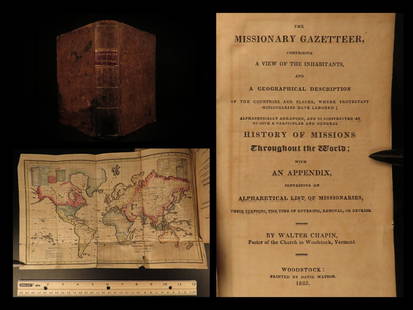
Sold20211825 1ed Missionary Gazetteer Chapin Slavery Indians1825 1ed Missionary Gazetteer Chapin Slavery Indians Illustrated Color World MAP ‘Missionary Gazetteer’ is a general history of missions throughout the world arranged alphabetically with an appendSee Sold Price
Sold20191884 BEAUTIFUL 9v Appleton American Cyclopaedia World1884 BEAUTIFUL 9v Appleton American Cyclopaedia World History Maps In the late 19th-century, the Appleton publishing company printed an enormous multi-volume encyclopedia of American biography. This sSee Sold Price
Sold20201855 Smith’s ATLAS Geography 36 BEAUTIFUL Colored MAPS1855 Smith’s ATLAS Geography 36 BEAUTIFUL Colored MAPS World ‘Smith’s Atlas of Modern and Ancient Geography’ is a collection of maps focusing on the United States, but includes maps of the worSee Sold Price
Sold20201883 1st Esoteric Occult Rivers of Life Forlong1883 1st Esoteric Occult Rivers of Life Forlong World Religions MAP Illustrated Major-General Forlong was a military engineer and scholar of world religions. Forlong’s ‘Rivers of Life’ is a two-See Sold Price
Sold20201855 Savage World Geography History MAPS Coins Commerce1855 Savage World Geography History MAPS Coins Commerce Native American INDIANS Charles Savage’s ‘The World, Geographical, Historical, and Statistical’ is a mid-19th-century account of the histoSee Sold Price
Sold20231833 ATLAS MAPS Cartography Navigation Voyages Illustrated French Petit Monin1833 ATLAS MAPS Cartography Navigation Voyages Illustrated French Petit Monin This incredible printing of Petit National Atlas features 96 impressive maps of world countries and islands, as well as FrSee Sold Price
Sold20201836 1st ed World As It Is Perkins Slavery Indians1836 1st ed World As It Is Perkins Slavery Indians Ireland Egypt Illustrated MAP ‘The World As It Is’ was written by Samuel Perkins to give a concise view of the nations of the world as it relatesSee Sold Price
Sold20231748 George Anson World Voyage 3 HUGE MAPS Spain South America Sea Navigation1748 George Anson World Voyage 3 HUGE MAPS Spain South America Sea Navigation George Anson was an 18th-century British Navy admiral who is noted for his important world voyage in which he circumnavigaSee Sold Price
Sold2024Carey, pub. 1814 - Map of the State of TennesseeThis engraved map is from Mathew Carey's General Atlas, improved and enlarged: being a collection of maps of the world and quarters, their principal empires, kingdoms, &c. The work was published in PhSee Sold Price
Sold20201813 Geography Atlas MAPS Benjamin Davies World Turkey1813 Geography Atlas MAPS Benjamin Davies World Turkey ASIA USA Ireland Davies’ “A new system of modern geography” was written as a middle ground between the verbose grammars of Pinkerton, GuthrSee Sold Price
Sold20221813 Geography Atlas MAPS Benjamin Davies World Turkey ASIA USA Ireland1813 Geography Atlas MAPS Benjamin Davies World Turkey ASIA USA Ireland Davies “A new system of modern geography” was written as a middle ground between the verbose grammars of Pinkerton,See Sold Price
Sold2024Carey, pub. 1814 - Map of Mexico or New SpainThis engraved map is from Mathew Carey's General Atlas, improved and enlarged: being a collection of maps of the world and quarters, their principal empires, kingdoms, &c. The work was published in PhSee Sold Price
Sold20231885 Atlas MAPS George Crams Unrivaled World Cerography Cartography HUGE FOLIO1885 Atlas MAPS George Crams Unrivaled World Cerography Cartography HUGE FOLIO A scarce, 19th-century atlas that showcases the best of George F. Crams cerographic color maps of the world. George F. CrSee Sold Price
Sold20231854 MAPS Atlas 1ed World in Middle Ages CRUSADES Rome Ottoman Medieval Koeppen1854 MAPS Atlas 1ed World in Middle Ages CRUSADES Rome Ottoman Medieval Koeppen Adolph Ludwig Koeppens “World in the Middle Ages” is a rare, 19th-century perspective on the state of the woSee Sold Price
Sold2024Carey, pub. 1814 - A Chart of the WorldThis engraved map is from Mathew Carey's General Atlas, improved and enlarged: being a collection of maps of the world and quarters, their principal empires, kingdoms, &c. The work was published in PhSee Sold Price
Sold2024Carey, pub. 1814 - Map of Italy & SardiniaThis engraved map is from Mathew Carey's General Atlas, improved and enlarged: being a collection of maps of the world and quarters, their principal empires, kingdoms, &c. The work was published in PhSee Sold Price
BonhamsPOTTER (BEATRIX) Peter Rabbit's Almanac for 1929, FIRST EDITION, AUTHOR'S PRESENTATION COPY, ins...£900
BonhamsJUVENILIA - MOVEABLE PARTS Lucinda, the Orphan; or the Costumes. A Tale Exhibited in a Series of...£600
10 hrs LeftLink Auction GalleriesHandbook of the United States of America, and Guide to Emigration; Giving the Lastest and Most$50
10 hrs LeftTrillium Antique Prints & Rare BooksSanson - Map of Canada or New France with the Great Lakes$75(1 bid)
10 hrs LeftTrillium Antique Prints & Rare BooksSanson - Map of Florida (encompassing most of Southeast North America)$130(2 bids)
10 hrs LeftTrillium Antique Prints & Rare BooksSanson - Map of the British Isles (Ireland, Scotland, England)$75
Jun 08Trillium Antique Prints & Rare BooksSanson - Map of California as an Island, Mexico (Audience de Guadalajara)$75
Jun 08Trillium Antique Prints & Rare BooksSanson - Map of North America with California as an Island$75(1 bid)


![Rare little 1820 American atlas: Heading: Author: Potter, Peregrine Title: [Atlas of the World] Place Published: Poughkeepsie, NY Publisher: Date Published: [1820] Description: With 6 (of 7) double-page engrave](https://p1.liveauctioneers.com/642/91039/46504548_1_x.jpg?height=310&quality=70&version=1468342277)