Sold2016E H Spencer Pictorial Map of Yorkshire, original posterE H Spencer Pictorial Map of Yorkshire, original poster printed for BR(NER) by British Colour Printing 1959 - 102 x 127 cm Property of the late Albert Cook ex Publicity Manager BR (NER)See Sold Price
Sold2016C Dohet (Claude dates unknown) Sabena Pictorial MapC Dohet (Claude dates unknown) Sabena Pictorial Map centring on Africa, original small poster printed by Linsmo c. 1960 - 34.5 x 22 cmSee Sold Price
Sold2021Ireland pictorial map showing places of interestIreland pictorial map showing places of interest original poster printed for Irish Tourist Board by Brown & Nolan c. 1960 - 102 x 63 cm and The Book of Kells original poster printed by Hely Thom 1964See Sold Price
Sold2018Signed Ernest Dudley Chase 1945 pictorial map of NorthTitle: A Pictorial Map of North America Map maker: Ernest Chase Dudley Place and Year: Winchester, 1945 Dimensions: 68.2 x 50.2 cm (26.9 x 19.8 in) Technique: Offset printing Coloring: Original printeSee Sold Price
Sold2016Anon Ireland Pictorial Map showing some of the placesAnon Ireland Pictorial Map showing some of the places of scenic and historic interest, original poster printed for the Irish Tourist Board by Browne & Nolan c.1960 - 102 x 63 cm; and Ireland AasleaghSee Sold Price
Sold2019CARUSO, Enrico (1873-1921). Caricatures by EnricoCARUSO, Enrico (1873-1921). Caricatures by Enrico Caruso. New York: Marziale Sisca "La Follia di New York", 1951. Quarto. Numerous printed caricatures by Caruso. Original publisher's pictorial wrapperSee Sold Price
Sold2022(2) LUCIEN BOUCHER , ORIGINAL PICTORIAL MAPLUCIEN BOUCHER (1889-1971) (2) ORIGINAL AIR FRANCE COLOR LITHOGRAPH PLANISPHERE PICTORIAL TRAVEL MAPS OF THE WORLD FOR AIRLINE DESTINATIONS OF AIR FRANCE , TITLED "NOVA ET VETERA" , Sur La Vieille TerSee Sold Price
Sold2023Leslie MacDonald Gill (1884-1947) 'The Wonderground Map of London Town' c. 1924England, 20th century. Printed and Published by the Westminster Press, 11 Henrietta Street, Covent Garden, [1927]. Pictorial map printed in full color, 29” x 36.5” plus margins. The map waSee Sold Price
Sold2022Framed Andy Dagosta Illustrated Map of California, 1969**Originally Listed At $250** Andrew "Andy" Dagosta (1923-2009). "California Lost Mines and Ghost Towns Early Spanish Missions" pictorial map, printed by Cooper Enterprises, Arizona, 1969. A vintage iSee Sold Price
Sold2019TRADE CATALOG-THE BERLIN IRON BRIDGE CO. EAST BERLIN,TRADE CATALOG-THE BERLIN IRON BRIDGE CO. EAST BERLIN, CT, CA. 1880'S. MEASURES APPROX. 6 3/4" X 10". ORIGINAL PICTORIAL PRINTED WRAPS. 127PP CONTAINING NUMEROUS DESIGNS FOR IRON BRIDGES THROUGHOUT NEWSee Sold Price
Sold2022[MUSIC]. Nebraska Folklore Pamphlets. Nebraska: Federal Wri...[MUSIC]. Nebraska Folklore Pamphlets. Nebraska: Federal Writers’ Project, 1937. 10 volumes, small 4to. Original pictorial printed wrappers (some uneven toning to covers). Includes Volumes 1̵See Sold Price
Sold2021CAPEK, KAREL. Tovarna na Absolutno.CAPEK, KAREL. Tovarna na Absolutno. Illustrated by Josef Capek.. 8vo, original pictorial wrappers printed in blue and orange, spine darkened with chipping to head and foot, stain on rear cover, edgeweSee Sold Price
Sold2023Jack Kerouac Book of DreamsHeading: Author: Kerouac, Jack Title: Book of Dreams Place Published: [San Francisco] Publisher:City Lights Books Date Published: [1961] Description: 184 pp. Original pictoSee Sold Price
Sold2023Vintage PosterA E Taylor (1887-1959) Pratt's High Test Plan of the Bath Road, original lithograph pictorial map poster 1930 - 49 x 74 cmSee Sold Price
Sold2018Scotland Pictorial Map - The British & Holiday Asso.Description: Antique framed original Scotland pictorial map by the permission of the British & Holiday Association.Measurement approximate: 32 H x 20 W. Material: All Pure Linen Fabric. Shipping cost:See Sold Price
Sold2022DOYLE, Arthur Conan (1859–1930). A Study inDOYLE, Arthur Conan (1859–1930). A Study in Scarlet. London: Ward, Lock & Bowden, 1895. 8vo. Illustrations by James Greig. Original publisher’s pictorial wrappers printed in red and blackSee Sold Price
Sold2022(PICTORIAL MAPS.) D.E. Bates. Cunard R.M.S. Caronia / Great African Cruise 1950.(PICTORIAL MAPS.) D.E. Bates. Cunard R.M.S. Caronia / Great African Cruise 1950. Color offset-printed pictorial map advertising the Caronia's route on a two-and-a-half-month's-long affair: departing NSee Sold Price
Sold2022(PICTORIAL MAPS.) Louise Jefferson. Africa, A Friendship Map.(PICTORIAL MAPS.) Louise Jefferson. Africa, A Friendship Map. Offset color-printed pictorial map of Africa. 28¼x26¼ inches sheet size; margins shaved to decorative border, imprint at lower eSee Sold Price
Sold2020(PICTORIAL MAP.) Whitney, Marjorie. A Plan of the(PICTORIAL MAP.) Whitney, Marjorie. A Plan of the Campus of the University of Kansas. Color-printed pictorial map on watermarked heavy stock. 14x18 inches sheet size, wide margins, lower deckle edge;See Sold Price
SoldTARTT, Donna. A group of 4 FIRST or LIMITED EDITIONS, MOST SIGNED. TARTT, Donna (b. 1963). A group of 4 FIRST or LIMITED EDITIONS, comprising: 1) The Secret History. New York: Alfred A. Knopf, 1992. Original pictorial boards and printed glassine dustSee Sold Price
Sold2021(PICTORIAL MAPS.) Robert J. Seymour; and Merritt L.(PICTORIAL MAPS.) Robert J. Seymour; and Merritt L. Ryder. Historical Westchester County. Color-printed pictorial map of Westchester County, New York. 22x17 inches sheet size, wide margins; old folds,See Sold Price
Sold2021CIRCA MID 20TH CENTURY, ORIGINAL ILLUSTRATION ART,CIRCA MID 20TH CENTURY, ORIGINAL ILLUSTRATION ART, PICTORIAL MAP OF MEMPHIS, TN CIRCA MID 20TH CENTURY, ORIGINAL ILLUSTRATION ART, PICTORIAL MAP OF MEMPHIS, TN Description CIRCA MID 20TH CENTURY, ORIGSee Sold Price
Sold2021Fort Ligonier: Outpost of the French and Indian WarSKU #: 020568 Title: Fort Ligonier: Outpost of the French and Indian War 1758-1766 Description: Stapled booklet, original cardboard wraps, map printed inside of front cover, 9pp., no writing in the boSee Sold Price
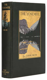
Sold2023 MUIR, John (1838-1914). The Yosemite. New York: The Century...MUIR, John (1838-1914). The Yosemite. New York: The Century Co., 1912. 8vo. 32 full-page plates from photographs, 3 folding maps. Original pictorial dark green cloth, top edge gilt (small spot of ghosSee Sold Price
Jun 07Freeman's | HindmanDICKENS, Charles. Our Mutual Friend. May 1864-November 1865. FIRST EDITION IN ORIGINAL MONTHLY$200
Jun 08Early American History Auctionsc 1730 Hand-Colored Colonial Era Map of the Americas, California shown as an Island, Matted + Framed$500
Featured1 day LeftJasper52Carte L’Asie. Asia. Mughal Empire. Oirat Kingdom. Tartary. VAUGONDY 1750 map$280
1 day LeftJasper52Les Indes Orientales… South Asia India Indochina Tibet. VAUGONDY 1751 map$120
May 30Forum AuctionsEco (Umberto) Il Problema Estetico in San Tommaso, presentation copy, Turin, Edizioni di Filosofia,£1,800
Jun 07Freeman's | HindmanGOODWIN, Archie, ed. Eerie. No.1. 1965. "ASHCAN" LIMITED FIRST ISSUE OF 200 COPIES.$175(2 bids)
Jun 06Freeman's | HindmanLONDON, Jack. The Call of the Wild. FIRST EDITION, FIRST ISSUE. In the FIRST ISSUE BINDING.$400
Jun 07Freeman's | HindmanCUNARD, Nancy, editor. Negro Anthology. 1934. FIRST EDITION. ASSOCIATION COPY WITH NOEL SULLIVAN$2,000
May 30Forum AuctionsChina.- Japan.- Manchuria Daily News Souvenir Enthronement Supplement March First 1934, [Dairen],£400
Jun 06Freeman's | HindmanNIN, Anaïs (1903–1977). Winter of Artifice. [New York: The Gemor Press, 1942].$200
2 days LeftForum AuctionsBread.- Acton (Eliza) The English Bread-Book for Domestic Use, Adapted to Families of Every Grade,£200
3 days LeftKinghams AuctioneersTolkien, J.R.R. 'The Hobbit, or There and Back Again', 1st ed, 1st impression, pub Allen & Unwin,£3,400
Jun 06Freeman's | HindmanSTEVENSON, Robert Louis (1850-1894). Treasure Island. London, Paris & New York: Cassell & Company,$1,500
Featured1 day LeftJasper52SIBERIA AND CHINESE TARTARY. Manchuria Mongolia Korea China. SDUK 1844 old map$20
1 day LeftJasper52SIBERIA & CHINESE TARTARY Manchuria Mongolia Korea China East Asia SDUK 1844 map$20


![Leslie MacDonald Gill (1884-1947) 'The Wonderground Map of London Town' c. 1924: England, 20th century. Printed and Published by the Westminster Press, 11 Henrietta Street, Covent Garden, [1927]. Pictorial map printed in full color, 29” x 36.5” plus margins. The map wa](https://p1.liveauctioneers.com/7899/310285/166001628_1_x.jpg?height=310&quality=70&version=1700492487)


![[MUSIC]. Nebraska Folklore Pamphlets. Nebraska: Federal Wri...: [MUSIC]. Nebraska Folklore Pamphlets. Nebraska: Federal Writers’ Project, 1937. 10 volumes, small 4to. Original pictorial printed wrappers (some uneven toning to covers). Includes Volumes 1̵](https://p1.liveauctioneers.com/928/252933/131522015_1_x.jpg?height=310&quality=70&version=1656110480)

![Jack Kerouac Book of Dreams: Heading: Author: Kerouac, Jack Title: Book of Dreams Place Published: [San Francisco] Publisher:City Lights Books Date Published: [1961] Description: 184 pp. Original picto](https://p1.liveauctioneers.com/642/285551/150656806_1_x.jpg?height=310&quality=70&version=1681523908)


![China.- Japan.- Manchuria Daily News Souvenir Enthronement Supplement March First 1934, [Dairen], (1 of 2)](https://p1.liveauctioneers.com/5458/329231/177514924_1_x.jpg?height=282&quality=70&version=1715269091)
![NIN, Anaïs (1903–1977). Winter of Artifice. [New York: The Gemor Press, 1942]. (1 of 2)](https://p1.liveauctioneers.com/197/329405/177652573_1_x.jpg?height=282&quality=70&version=1715364568)


