Sold2022(2) LUCIEN BOUCHER , ORIGINAL PICTORIAL MAPLUCIEN BOUCHER (1889-1971) (2) ORIGINAL AIR FRANCE COLOR LITHOGRAPH PLANISPHERE PICTORIAL TRAVEL MAPS OF THE WORLD FOR AIRLINE DESTINATIONS OF AIR FRANCE , TITLED "NOVA ET VETERA" , Sur La Vieille TerSee Sold Price
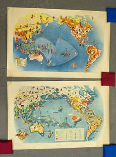
Sold2022LUCIEN BOUCHER , ORIGINAL AIR FRANCE PLANISPHEREOriginal Air France Planisphere Travel Map by Lucien Boucher , LUCIEN BOUCHER (1889-1971) ORIGINAL AIR FRANCE COLOR LITHOGRAPH PICTORIAL PLANISPHERE MAP OF THE WORLD FOR AIRLINE DESTINATIONS OF AIR FRSee Sold Price
Sold2022LUCIEN BOUCHER , ORIGINAL AIR FRANCE PLANISPHEREOriginal Air France Planisphere Travel Map by Lucien Boucher , LUCIEN BOUCHER (1889-1971) ORIGINAL AIR FRANCE COLOR LITHOGRAPH PICTORIAL PLANISPHERE MAP OF THE WORLD FOR AIRLINE DESTINATIONS OF AIR FRSee Sold Price
Sold2020Boucher, Lucien (1889–1971). Air France / Le PlusBoucher, Lucien (1889–1971). Air France / Le Plus Grand Réseau du Monde. Paris: Perceval, 1959. Pictorial map showing the flight path for Air France that reaches globally, vignette borders.See Sold Price
Sold2024Original Air France Map of the Zodiac Created by Lucien Boucher in 1950This is one of the most desirable posters ever created by Lucien Boucher, for Air France. In it we see the various destinations that Air France flew to in the 1950s. Boucher uses the signs of the ZodiSee Sold Price
Sold2018Original Air France Zodiac Map Lucien BoucherOriginal Poster Air France Zodiac Map Lucien Boucher on Linen PaperSee Sold Price
Sold2023Original Vintage Indochine Francaise Map by Lucien Boucher 1935 Vietnam Laos CambodiaAs one can only imagine, travel in the Far East in the 1920's must have been a challenging adventure. This well illustrated map poster by master artist, Lucien Boucher shows the various routes once coSee Sold Price
Sold2016Lucien Boucher Air France World Map of Air Routes,Lucien Boucher Air France World Map of Air Routes, original poster printed by Perceval c.1939 - 63 x 99 cmSee Sold Price
Sold2016Lucien Boucher Air France World Map of Air Routes,Lucien Boucher Air France World Map of Air Routes, original poster printed by Perceval c.1939 - 64 x 101 cm Crinkled paperSee Sold Price
Sold2021Rare Original 1950s Air France 8-Panel Map Poster BouchBoucher, Lucien 1889 - 1971Air France - Le Plus Grande Reseau du Monde (Billboard)Lithograph 1959102.3 x 165.3 in. (260 x 420 cm)Printer: Perceval, ParisCondition Details: (A-) in 8 panels, small tearSee Sold Price
Sold2018Signed Ernest Dudley Chase 1945 pictorial map of NorthTitle: A Pictorial Map of North America Map maker: Ernest Chase Dudley Place and Year: Winchester, 1945 Dimensions: 68.2 x 50.2 cm (26.9 x 19.8 in) Technique: Offset printing Coloring: Original printeSee Sold Price
Sold2022FRAMED AIR FRANCE POSTER BY LUCIEN BOUCHER"PLANISPHERE", CONSTELLATION MAP FROM 1938, AN EXAMPLE OF 200, 25 1/2" H, 40 1/2" W,See Sold Price
Sold2021West Indies.- Bahamas.- Stark (James H.) Stark'sNO RESERVE West Indies.- Bahamas.- Stark (James H.) Stark's History and Guide to the Bahama Islands, plain plates, 2 folding maps, ink ownership inscription to front pastedown, original pictorial boarSee Sold Price
Sold2022In Darkest Africa6 volumes. Subscribers original edition 2 volumes in six divisions. With 165 woodcut illustrations and maps. Hard to find a full-set in such good condition. Publishers original pictorial covers with gSee Sold Price
Sold2017[Magic] Houdini, Harry. The Adventurous Life of a[Magic] Houdini, Harry. The Adventurous Life of a Versatile Artist. Houdini. [New York, 1922]. For a performance at the Orpheum week of April 2. Original pictorial orange wrappers. Lightly stained.See Sold Price
Sold2022Carl Rose Collection of 2 Original Illustrations MapsCarl Rose Collection of 2 Original Illustrations. MAP Of U.S. G. R. Gin Rummy locations. Map of Straw Hat Circuit 1947 . Carl Rose, 1903 – 1971 was an American cartoonist whose work appeared inSee Sold Price
Sold2023Vintage PosterA E Taylor (1887-1959) Pratt's High Test Plan of the Bath Road, original lithograph pictorial map poster 1930 - 49 x 74 cmSee Sold Price
Sold2023[CANADIAN ANTIQUE MAP] BRITISH AMERICA. C.1850[CANADIAN ANTIQUE MAP] BRITISH AMERICA. Hand-coloured.Circa 1850sPublished by John Tallis, London and NY, 1850Frame size: (approx) 17.1/2"x21.1/2"Original Tallis map of British America (now Canada). VSee Sold Price
Sold2018Scotland Pictorial Map - The British & Holiday Asso.Description: Antique framed original Scotland pictorial map by the permission of the British & Holiday Association.Measurement approximate: 32 H x 20 W. Material: All Pure Linen Fabric. Shipping cost:See Sold Price
Sold2023Vtg Sandy Hook Bay, NJ & Coastal Waterways 2-Sided Original Map & NOT A COPY! (24.5" x 36")Vintage Sandy Hook Bay, NJ & Coastal Waterways 2-Sided Original Map & NOT A COPY! (24.5" x 36") Preowned from an Estate. $5 DOMESTIC SHIPPING!See Sold Price
Sold2021Covarrubias Pacific Asia Pictorial Maps (2)Maps of the Pacific, Golden Gate International Exposition. NY, 1942. Miguel Covarrubias (1904-1957). 2 Maps: Peoples and Economy. Australia, Hawaii, Asia, Americas. .See Sold Price
Sold2022Robert Louis Stevenson New Arabian NightsHeading: Author: Stevenson, Robert Louis Title: New Arabian Nights Place Published: London Publisher:Chatto & Windus Date Published: 1882 Description: 2 volumes. (8vo) originalSee Sold Price
Sold2024A Journey to the North Pole[Literature] Verne, Jules. A Journey to the North Pole. London and New York: George Routledge and Sons, 1875. Octavo, pp. [i-iii] iv [1] 2-314 pp., original pictorial red-brown grained cloth, front anSee Sold Price
Sold2021CIRCA MID 20TH CENTURY, ORIGINAL ILLUSTRATION ART,CIRCA MID 20TH CENTURY, ORIGINAL ILLUSTRATION ART, PICTORIAL MAP OF MEMPHIS, TN CIRCA MID 20TH CENTURY, ORIGINAL ILLUSTRATION ART, PICTORIAL MAP OF MEMPHIS, TN Description CIRCA MID 20TH CENTURY, ORIGSee Sold Price
4 days LeftTremont Auctions17th century "Sub Polo Artico" original map by Blaeu. 2 sided framing. Overall: 18.375 x 22.5in.$225(2 bids)
4 days LeftTremont Auctions17th century original map 1676 "Virginia and Maryland" by John Speed. 2 sided framing. Overall:$325(2 bids)
4 days LeftTremont Auctions17th century original map of Magellan Straights by Mercator and Hondius. 2 sided framing. Overall:$150
May 16Potter & Potter AuctionsPictorial Map of Hollywood and Vicinity / Hollywood Film Ca...$125(1 bid)
May 16Potter & Potter AuctionsLINDGREN, Jolly (1895-1952). A Hysterical Map of Yellowstone Park and the Jackson Hole Country$125
May 16Potter & Potter AuctionsLINDGREN, Hjalmer “Jolly” (1895–1952). A Hysterical Map of ...$200
May 16Potter & Potter AuctionsMcCARTY, Lea (1905 – 1960). Sonoma County / Its Highlights ...$100(1 bid)
May 16Potter & Potter AuctionsBOURNE, Emma (1906 – 1986). America – A Nation of One Peopl...$125(1 bid)
May 16Potter & Potter AuctionsBODLEY, Helen (1906 – 1997). A Map of Concord / The Old Mus...$400
May 16Potter & Potter AuctionsLINDGREN, Hjalmer “Jolly” (1895–1952). A Hysterical Map of ...$150(1 bid)
May 16Potter & Potter AuctionsBATE, Neel (1916 – 1989). Jimmy and Sally in Mother Goose L...$200
May 16Potter & Potter AuctionsBOUCHER, Lucien (1889 – 1971). Provence Breguet 763 / Air F...$300
6 days LeftJasper521970s Hawaiian Airlines Pictorial Route Map -- Hawaiian Airlines Map of the Hawaiian Islans$35
3 days LeftBid Again Auctions (American Space Museum)4 - Lunar Orbiter I Original Site Map Photographs$50
3 days LeftOAB AuctionsLucien Dulfan Original Oil Painting On Canvas Signed Figurative Framed Artwork$500


![[Magic] Houdini, Harry. The Adventurous Life of a: [Magic] Houdini, Harry. The Adventurous Life of a Versatile Artist. Houdini. [New York, 1922]. For a performance at the Orpheum week of April 2. Original pictorial orange wrappers. Lightly stained.](https://p1.liveauctioneers.com/928/104923/53750021_1_x.jpg?height=310&quality=70&version=1496865216)


![[CANADIAN ANTIQUE MAP] BRITISH AMERICA. C.1850: [CANADIAN ANTIQUE MAP] BRITISH AMERICA. Hand-coloured.Circa 1850sPublished by John Tallis, London and NY, 1850Frame size: (approx) 17.1/2"x21.1/2"Original Tallis map of British America (now Canada). V](https://p1.liveauctioneers.com/8321/286473/155235081_1_x.jpg?height=310&quality=70&version=1686868575)


![A Journey to the North Pole: [Literature] Verne, Jules. A Journey to the North Pole. London and New York: George Routledge and Sons, 1875. Octavo, pp. [i-iii] iv [1] 2-314 pp., original pictorial red-brown grained cloth, front an](https://p1.liveauctioneers.com/179/322586/173446545_1_x.jpg?height=310&quality=70&version=1710273379)


