Sold2021San Diego with pictorial recreation map 1935Heading: (California - San Diego) Author: Title: Map of San Diego California City and County - with two maps, one a pictorial bird's-eye map Place Published: [San Diego] Publisher:Lowell E. Jones <See Sold Price
Sold2022California Pictorial MapFun Map of Southern California. All-Year Club, c. 1930s. Recreational activities. Santa Barbara, Malibu, Los Angeles, Santa Monica, San Diego. 11" x 11".See Sold Price
Sold20211889 San Diego MapTitle: 1889 San Diego Map Author: Cram Medium: Ink on Paper Dimensions: 11.5"X14.5" Description: Map of San Diego dated 1889. Engraved and published by George Cram in Chicago. Very detailed. Color codSee Sold Price
Sold2023(3) Gold Gulch Coupons San Diego 1935(3) Gold Gulch Coupons San Diego 1935, America's Exposition. They measure 6.125 x 2.625 inches. If lot is absent of a condition report one may be requested via email. Condition report is provided as aSee Sold Price
Sold2023(3) Jardin de Plaisir Coupons San Diego 1935(3) Jardin de Plaisir Coupons San Diego 1935, America's Exposition. They measure 6.125 x 2.625 inches. If lot is absent of a condition report one may be requested via email. Condition report is providSee Sold Price
Sold2016Rare Taylor San Diego Mission Pictorial Tiles CA550A front elevation of the San Diego Mission, exceptionally elegant and simple design. Could be set in a table or as a plaque. Provenance: Santa Barbara estate Measurement: This item ships from Los AngeSee Sold Price
Sold2021Rare guide to San Diego with map 1911Heading: (California - San Diego) Author: Title: San Diego Pocket Guide: A compendium of general information of the city of San Diego, with latest map, carefully compiled from latest sources Place PuSee Sold Price
Sold20231940s San Francisco Bay Area Pictorial Map - San Francisco Bay Metropolitan Area - Attached to1940s San Francisco Bay Area Pictorial Map - San Francisco Bay Metropolitan Area - Attached to Poster Board from S.F. Economic Survey 1943 by S.F. Chamber of Commerce 31.5'' x 26''See Sold Price
Sold2023Williamson, Lieut. R. S. 1856 HC Map. San Diego & Colorado River California"Geological Map of the Country Between San Diego and the Colorado River California" By W. P. Blake. Hand Colored Lithograph Map Published 1853-61, Washington for "Reports of explorations and surveys,See Sold Price
Sold2017FIRESTONE RUBBER 1935 FORD PROMOred, 4 7/8 in long, made at the 1935 San Diego Expo, actual car photographed for the rubber toy book, orig box rough, C8.See Sold Price
Sold2022Rare Ca.1935 San Diego Expo Sheriff's Badge[California Pacific International Exposition] Rare Ca.1935 San Diego Expo Sheriff's Badge. Measures 1.5 x 1.25 inches. Excellent condition. If lot is absent of a condition report one may be requestedSee Sold Price
Sold20182 FIRESTONE EXPOSITION FORDS1936 Great Lakes Exposition, blue, has cracking & 2 small holes in running boards, 1935 San Diego Exposition, red, decal on roof, C5-6.See Sold Price
Sold20162-1935 SAN DIEGO EXPO FIRESTONE FORD SEDANSNice pair of 5" Ford sedans from the 1935 San Diego Expo, have general wear and paint crazing. Hard to find pair of souvenir cars. Very GoodSee Sold Price
Sold20211848 1ed Military Emory Reconnaissance MAPS Indians1848 1ed Military Emory Reconnaissance MAPS Indians California Texas San Diego 39 Engravings, Maps, Views / compare@$7500 Incredible work on westward expedition of William H Emory with detailed illustSee Sold Price
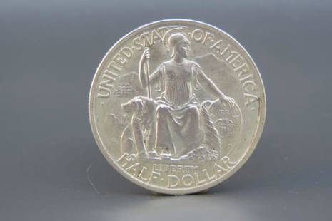
Sold20211935 S San Diego Silver Half Dollar UNCThis souvenir half dollar was in San Francisco in 1935 and in Denver in 1936. This is a gorgeous example of the San Diego commemorative silver half dollar in Gem Uncirculated.See Sold Price
Sold20211935 S San Diego Commemorative Silver Half DollarEarly PCGS Rattler Holder, Bright White Obverse & Reverse, Great Eye Appeal.See Sold Price
Sold20201939 White Pictorial Map of San Francisco's TreasureTitle: 1939 White Pictorial Map of San Francisco's Treasure Island -- A Cartograph of Treasure Island in San Francisco Bay; Golden Gate International Exposition Cartographer: Ruth Taylor White Year/PlSee Sold Price
Sold20181939 White Pictorial map of San Francisco's TreasureTitle/Content of Map: 1939 White Pictorial map of San Francisco's Treasure Island -- A Cartograph of Treasure Island in San Francisco Bay; Golden Gate International Exposition Date Printed: 1939, SanSee Sold Price
Sold2022Vintage Map - Map of San Diego Zoo - Zoological Society of San Diego - United StatesA whimsically colorful vintage map of San Diego Zoo - a fun cartoon print illustration from the 1983. You will receive the exact antique map in the photos. The condition is very good considering the aSee Sold Price
Sold2017Vintage Pictorial Map of San Francisco, 1947Title/Content of Map: 1947 Pictorial Map of San Francisco -- 49 Mile Scenic Drive, San Francisco Date Printed: 1947, San Francisco Cartographer: San Francisco Downtown Association Size: 9 X 12 in. A vSee Sold Price
Sold2024Pictorial Map of San Francisco, 1946Bright and colorful pictorial map of San Francisco from 1946. Note many historical and cultural sites depicted in playful designs, adorned with elaborate title cartouche.Size: 16 cm x 11 cmSee Sold Price
Sold2023U.S. Classic Commemorative 50C Silver Coins, thirteenU.S. Classic Commemorative 50C Silver Coins, thirteen Lot includes: 1920 Maine, 1935-S San Diego, 1936 Cleveland, 1936 Long Island, 1924 Huguenot, 1925 Stone Mountain, 1946 Iowa, 1936 Boone, 1923-S MoSee Sold Price
May 16Potter & Potter AuctionsMap to Acquaint You with the Great Mission Bay Project. 194...$125(1 bid)
May 16Potter & Potter AuctionsHANDY, R.D. (1879 – 1959). Paul Bunyan’s Pictorial Map of t...$200
7 days LeftJasper52Central America Caribbean Gulf of Mexico chart Ports lighthouses LARGE 1918 map$45
May 16Potter & Potter AuctionsPictorial Map of Hollywood and Vicinity / Hollywood Film Ca...$125(1 bid)
May 16Potter & Potter Auctions[NEW YORK CITY – PICTORIAL MAPS]. Group of 3 pictorial maps...$200(1 bid)


![San Diego with pictorial recreation map 1935: Heading: (California - San Diego) Author: Title: Map of San Diego California City and County - with two maps, one a pictorial bird's-eye map Place Published: [San Diego] Publisher:Lowell E. Jones <](https://p1.liveauctioneers.com/642/218849/112379283_1_x.jpg?height=310&quality=70&version=1631923877)


![Rare Ca.1935 San Diego Expo Sheriff's Badge: [California Pacific International Exposition] Rare Ca.1935 San Diego Expo Sheriff's Badge. Measures 1.5 x 1.25 inches. Excellent condition. If lot is absent of a condition report one may be requested](https://p1.liveauctioneers.com/5755/269573/141096346_1_x.jpg?height=310&quality=70&version=1669076734)


![Finlandia / Suomi. 1949. [Five copies]. Helsinki: Kustannus... (1 of 1)](https://p1.liveauctioneers.com/928/325952/175495564_1_x.jpg?height=282&quality=70&version=1712935174)


![[NEW YORK CITY – PICTORIAL MAPS]. Group of 3 pictorial maps... (1 of 3)](https://p1.liveauctioneers.com/928/325952/175495562_1_x.jpg?height=282&quality=70&version=1712935174)