Sold2020SDUK: South Asia, Australia and Oceania (2 sheets)The highly detailed gnomonic projection two-page map of South Asia (from the Arabian Peninsula to Indonesia), Australia, and Oceania engraved by J. & C. Walker and published by Charles Knight for theSee Sold Price
Sold2022Antique Map of Oceania - Map of South Australia - Adelaide - John BartholomewAntique map by John Bartholomew & Co for The Edinburgh Geographical Institute. Large chromolithographed map. Technique: Chromolithography. Date: 1880. Artist: John George Bartholomew and Son. Place: ESee Sold Price
Sold2018SDUK: Map of Asia & Australia on Gnomonic ProjectionTitle/Content of Map:'WORLD ON GNOMONIC PROJECTION, IV, Asia.' Cotidal lines are marked on the map. ASIA AUSTRALIA. On Gnomonic Projection. China Indian Ocean. Date Printed: 1846 Image Size: Approx 32See Sold Price
Sold2024Brockhaus (Pub) 1880's Lot of 21 Antique MapsIncl Balkans, World, Switzerland, Italy, Great Britain, France, Germany, Ethnographic Maps, Europe, Africa, Australia/Polynesia, Asia, South America, Hungary, Scandinavia and others. Lithograph Maps PSee Sold Price
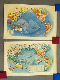
Sold2021Covarrubias Pacific Asia Pictorial Maps (2)Maps of the Pacific, Golden Gate International Exposition. NY, 1942. Miguel Covarrubias (1904-1957). 2 Maps: Peoples and Economy. Australia, Hawaii, Asia, Americas. .See Sold Price
Sold2022Ratzel, Friedrich 1898 Lot of 5 Ethnographic MapsIncl Oceania/Australia, Africa, America, Asia/Europe. Lithograph Maps Published 1896-98, London for "The History of Mankind" by Professor Friedrich Ratzel. Translated by A. J. Butler. Reverse side blaSee Sold Price
Sold2024South-East Asia. Indochina in 1944. Ports. World War 2 naval campaigns 1961 mapCAPTION PRINTED BELOW PICTURE: 'South-East Asia' DATE PRINTED: 1961 IMAGE SIZE: Approx 23.5 x 16.0cm, 9.25 x 6.25 inches (Medium) TYPE: Vintage military history map CONDITION: Good; suitable for framiSee Sold Price
Sold2017Rand McNally Map India, Burma, Nepal and Ceylon, 1898Map: 1898 Rand McNally India, Burma, Nepal and Ceylon -- India Cartographer: Rand McNally Year / Place: 1898, Chicago Map Dimension: 26.2 X 19.2 in. A very nice map of South East Asia. Highly detailedSee Sold Price
Sold20191845 Lizars Map of Asia and Australia -- AsiaReserve Reduced! Title/Content of Map: 1845 Lizars Map of Asia and Australia -- Asia Date: 1845 c., Edinburgh Cartographer: D Lizars Size: 10.8 X 9.2 in. This is very nice map of Asia and Australia wiSee Sold Price
Sold2017Homann Heirs, Charte van AsienHomann Heirs, Charte van Asien, Homann Heirs (18th c.), "Charte von Asien", c. 1793, hand-colored map of the continent including all of South East Asia and the northern tip of Australia, 20.5"h x 24.5See Sold Price
Sold2021Walker/SDUK: South America, 1842Title/Content of Map: Walker/SDUK: South America, 1842 Date Printed: 1842, London Cartographer: J. Walker / Society for the Diffusion of Useful Knowledge Size: 12 1/2" x 15 3/4" Walker's highly detailSee Sold Price
Sold2023Visscher Map of South East AsiaVISSCHER, Nicolas (1618-1679). Indiae Orientalis, nec non Insularum Adiacentium Nova Descriptio. Engraved map with great original hand color in full. Amsterdam, c. 1698. 20 1/2" x 24 1/8" sheet. ThisSee Sold Price
Sold2015South East Asia.- Fytche - Burma Past and Present with( Lt-Gen . Albert) Burma Past and Present with Personal Reminiscences of the Country , 2 vol., first edition , half-titles, 2 engraved portraits, 13 plates (10 chromolithographed), folding map at endSee Sold Price
Sold2019Oceania, Australia and islands of the Pacific OceanTitle/Content of Map: Oceania, Australia and islands of the Pacific Ocean Date: 1852 Cartographer: Mitchell Size: 12x9 1/2” Provenance: Philadelphia Additional Info: From ‘school atlas’. ReserveSee Sold Price
Sold2017SDUK: China, Southeast AsiaCartographer: Baldwin & Cradock, Society for the Diffusion of Useful Knowledge Place & Date: London / 1834 Size: 15" x 12 1/2" Condition: b&w; light overall age toning A highly detailed China map fromSee Sold Price
Sold2017SDUK: Map of South Africa, 1834Map: South Africa Cartographer: Baldwin & Cradock, Society for the Diffusion of Useful Knowledge Place & Date: London / 1834 Size: 15 1/2" x 12 1/4" The highly detailed South Africa map from the SDUKSee Sold Price
Sold2018Maps C1800-C1940 Mixed Lot of 16Mixed lot on Lithograph and Engraved Maps. Incl German Empire, West Indies, Ireland, Asia, Switzerland, France, South Atlantic, Africa, World and Paris. Examples by SDUK, ILN, Bartholomew/Philip, LogeSee Sold Price
Sold2024Andrew Garran - Map of South Australia / Map of Northern Territory of South AustraliaLithographed maps originates from "Picturesque atlas of Australasia", 1st edition, published in Sidney 1886-88 by Andrew Garran. Size: 44 cm x 36,5 cm.See Sold Price
Sold2019Bartholomew, John 1922 North & South Pole, 2 MapsLarge Lithograph Maps Published 1922 by The Times, London for "The Times Survey Atlas of the World" Maps by John George Bartholomew of the Edinburgh Geographical Institute. Centre fold as issued. PapeSee Sold Price
Sold2019Vietnam era pilot notes, guides, lineups, target mapsThis lot includes a large amount of notes, briefing guide material, photographs, slides, flight line ups, hand written day strike notes, Vietnam and south east Asia maps, pilots NOS mapstrap, and moreSee Sold Price
Sold2023Asian 2 part bronze Shakyamuni sitting Buddha: believed to be 19th to Early 20th Century, South toBelieved to be 19th to Early 20th Century, South to South East Asia 2 part bronze Shakyamuni sitting Buddha, 10"w x 7"d x 16"h does show age, patina, and wearSee Sold Price
Sold2022Encyclo. Britannica 1890's Pair of Australia MapsNew South Wales and South Australia. Lithograph Map Published 1875-98, Edinburgh & London for "Encyclopaedia Britannica" Ninth Edition. Paper Size: 10.5 x 8 inch (27 x 21cm) Good ConditionSee Sold Price
Sold2022Nat. Encyclo. C1875 Lot of 6 Views, VolcanoesIncl St. Gothard Tunnel, Venetian Architecture, Mont Cenis Tunnel, Stalactite Caves South Australia, and 2 plates of Volcanoes. Woodblocks and/or Steel Engravings Published C1868-81 by William MackenzSee Sold Price
Sold20232 South Asia silver bowls2 South Asia silver bowls (tested positive for silver, content unknown), wt. 731.5gm, 2.5"x5"dia, 5.15"x8.9"diaSee Sold Price
Jul 16BADO e MART AUCTIONSSouth Asia - Eastern Europe. DE BRUYN. Reizen over Moskovie, door Persie en Indie.€3,750
4 days LeftTrillium Antique Prints & Rare BooksPrevost - Chart of the South Pacific Ocean with part of New Holland (Australia), New Zealand, and$75
4 hrs LeftMynt Auctions1934 Registered Australia Papua New Guinea Dual Postage FFC Cover Ashfield NSW 2$130
4 days LeftTrillium Antique Prints & Rare BooksOxley - Map of the New South Wales, Australia (New Holland)$100
Jul 03Rob Michiels AuctionsAn exceptional collection of terracotta idols, Mehrgarh, Syro-Hittite states and Indus Valley, 35th/€4,800
Jul 18Weatherham Estate Treasures5" x 5" Framed Male Long-Tail Metalmark Butterfly - Rhetus Arcius$74
4 days LeftBidhausAustralian South Sea Pearl Diamond Cluster Cocktail Ring 2 Carats 14K White Gold$10
2 days LeftNY Elizabeth ANTIQUE MAP-ILLUSTRATED FLORAL ILLUSTRATION 1761 NEW DICTIONARY OF TRADE AND COMMERCE R. ROTH$100
Jul 04Weatherham Estate Treasures9" x 7" - Framed Eupatorus Gracilicornis Rhinoceros Beetle with Wings Spread$110
11 hrs LeftJasper521903 CENTRAL ASIA and TIBET by SVEN HEDIN 2 VOLUMES antique TRAVEL illustrated$200(1 bid)
Freeman's | Hindman[MAPS-THE AMERICAS]. 11 maps, incl. [Herrera y Tordesillas]. Descripcion de las Yndias Ocidentales. $250


![SDUK: South Asia, Australia and Oceania [2 maps] First Image](https://p1.liveauctioneers.com/5584/141761/71765373_1_x.jpg?height=300&quality=1&version=1557879901&width=300)
![SDUK: South Asia, Australia and Oceania [2 maps] First Image](https://p1.liveauctioneers.com/5584/141761/71765373_1_x.jpg?height=300&quality=95&version=1557879901&width=300)


![[MAPS-THE AMERICAS]. 11 maps, incl. [Herrera y Tordesillas]. Descripcion de las Yndias Ocidentales. (1 of 6)](https://p1.liveauctioneers.com/197/333931/180433599_1_x.jpg?height=282&quality=70&version=1719251534)