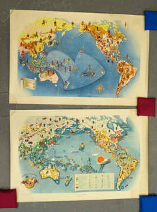
Sold2021Covarrubias Pacific Asia Pictorial Maps (2)Maps of the Pacific, Golden Gate International Exposition. NY, 1942. Miguel Covarrubias (1904-1957). 2 Maps: Peoples and Economy. Australia, Hawaii, Asia, Americas. .See Sold Price
Sold2021(PICTORIAL MAPS.) Miguel Covarrubias. Pageant of the(PICTORIAL MAPS.) Miguel Covarrubias. Pageant of the Pacific. Set of 6 large offset color lithographed maps. 25x38 and 19x25 inches each sheet size; without portfolio or descriptive pamphlet; soft verSee Sold Price
Sold2021World War II Pictorial Battle Maps (2)VII Corps. With XIX Corps in Action From Secured Line to Victory. 2 WWII European theater maps, American troops and allies, movements with illustrations. Sights 20 1/2" x 27 1/2", overall 22" x 29".See Sold Price
Sold20181944 Western Pacific Railroad Pictorial Map of WesternTitle/Content of Map: 1944 Western Pacific Railroad Pictorial Map of Western US with Illustrations -- From San Francisco along the line of Western Pacific Railroad to Salt Lake City Date: 1944, DenverSee Sold Price
Sold2022[PACIFIC NORTHWEST]. Two pictorial maps of Oregon and Washi...[PACIFIC NORTHWEST]. Two pictorial maps of Oregon and Washington. Including: -- PETRUCCELLI, Antonio (1907-1994). Pictorial map of Washington and Oregon. 1940. Art Deco style map of the Pacific NorthwSee Sold Price
Sold20202 Maps of Asia2 Maps of Asia- 1). John Cary- ''A New Map of China, From the Latest Authorities''- engraved map, 1801, some minor staining in margins. 18 1/2 x 20 1/2'' 2). John Thomson- ''Corea and Japan''- engraveSee Sold Price
Sold2023Lot of 2 Africa, Asia Maps 1808-1809. Size 13 1/2 x 10 1/2 inches lengthLot of 2 Africa, Asia Maps 1808-1809. Size 13 1/2 x 10 1/2 inches length. The map shows Africa way before the infamous expedition by John Hanning Speke to the source of the Nile.See Sold Price
Sold2023Lizars, Daniel 1831 LG Rare HC Map. Asia on 2 SheetsLarge Folio Copper Engraved Map Published 1831-2 by John Hamilton, Successor to Daniel Lizars, Edinburgh for "The Edinburgh Geographical and Historical Atlas..." First Edition by Daniel Lizars. Very fSee Sold Price
Sold2017PanAm: Vintage Pictorial Map of Asia, 1960Map: 1960 PanAm Pictorial Map of Asia -- Asiae Cartographer: J Liozu / PanAm Year / Place: 1960 Map Dimensions: 11.8 x 9 in. Condition: Very Good. Nice, sharp image and colors.Later center-fold. VerySee Sold Price
Sold2020(2) HANDCOLORED MAPS OF ASIABurma, Siam, French Indo-China and Straits Settlements and Physical Map of Asia . Dimensions: H 9.75" x W 12.75" Condition: Folding, toning and a tear to the middle of the Map of Asia.See Sold Price
Sold2022(2) LUCIEN BOUCHER , ORIGINAL PICTORIAL MAPLUCIEN BOUCHER (1889-1971) (2) ORIGINAL AIR FRANCE COLOR LITHOGRAPH PLANISPHERE PICTORIAL TRAVEL MAPS OF THE WORLD FOR AIRLINE DESTINATIONS OF AIR FRANCE , TITLED "NOVA ET VETERA" , Sur La Vieille TerSee Sold Price
Sold2022(CAPTAIN COOK.) John Webber, et al. [Atlas to] A Voyage to the Pacific Ocean.(CAPTAIN COOK.) John Webber, et al. [Atlas to] A Voyage to the Pacific Ocean. 2 engraved maps, 61 engraved plates. Folio, 22½x17 inches, contemporary boards, well-worn and partly disbound; dampstSee Sold Price
20182 World War II maps2 World War II maps. Pacific and European Theater. Title: 2 World War II map. Framed. Medium: Print. Size: 9.5 X 7.5See Sold Price
Sold2023Hornaday (2) 19TH C. Hunting Books SIGNEDTwo (2) William Hornaday inscribed and signed illustrated books. Includes: 1) Two Years in the Jungle. 1886. Charles Scribner's Sons. 512 pp. with fold out map. Cloth pictorial covers. 2) The Man WhoSee Sold Price
Sold20181935 ArizonaBy: Ruth Taylor Date: 1935 (Published) Boston Dimensions: 11.5 x 8.5 inches (29.2 cm x 22.2 cm) This colorful pictorial map of Arizona was done in 1935 by Ruth Taylor. It appeared in the atlas publishSee Sold Price
Sold20182 Maps: Stato Del Gran Turco + Asia Minoris.[De Rossi/Middle East] 2 Maps. ++ Stato Del Gran Turco diviso ne suoi Beglierbati, o Governi, e ne Principati, che li sono Tributari. Elaborate map of the Middle East, including Greece, Italy, the CasSee Sold Price
Sold2023Chart of the northern passage between Asia & America. Pacific. THOMSON 1830 mapTITLE/CONTENT OF MAP: 'Chart of the northern passage between Asia and America' DATE PRINTED: 1830 IMAGE SIZE: Approx 53.0 x 65.0cm, 21 x 25.5 inches (Large); Please note that this is a folding map. TYSee Sold Price
Sold2015De Bry (Theodore) - Descriptio Hydrographicathe 2-sheet map of Africa and Asia, from the east coast of Brazil to Japan, charting the first Dutch voyage to the East Indies by Houtman, large titlecartouche upper centre of right sheet, ships, compSee Sold Price
Sold2021(2) 19th Century Architectural Renderings(2) 19th Century Architectural Renderings 19th Century Pictorial Map. Lithographs. (lg) 32 x 26 1/2 in. (sm) 21 x 23 in. The estate of Dr. Seymour Ira Schwartz, Rochester, New York.See Sold Price
Sold2017Thomson: Map of the Islands of the Pacific Ocean, 1817Map: Map of the Islands of the Pacific Ocean Cartographer: Thomson Place & Date: Edinburgh / 1817 Size: 23 3/4" x 19 1/2" The grand Pacific Islands map from Thomson's New General Atlas, showing all thSee Sold Price
Sold2021Ruth Taylor White Hawaii Pictorial Maps (4)Island of Hawaii. Maui. Oahu. Kauai. Set of 4 Cartographs. Printed by The Paradise of the Pacific for the Hawaii Tourist Bureau, Honolulu. C. 1935. Ex library..See Sold Price
Sold2023[PICTORIAL MAPS]. Two maps. Includes: JANNOT, J.B. (“Jan Lo...[PICTORIAL MAPS]. Two maps. Includes: JANNOT, J.B. (“Jan Loup”). Grand Circuit Des Capitales. France: Agence Francaise de Propagande. Promotional map of Europe and Asia for Menier chocolatSee Sold Price
Sold2023ESTATE OF SEYMOUR STEIN: 4 SMALL FRAMED MAPS (2) OF EUROPE (1) OF N. AMERICA (1) OF ASIA 12" X 15"ESTATE OF SEYMOUR STEIN: 4 SMALL FRAMED MAPS (2) OF EUROPE (1) OF N. AMERICA (1) OF ASIA 12" X 15"See Sold Price
May 09Hunt and Peck Estate Services, Inc.1784 Captain James Cook "A Voyage to the Pacific Ocean" 2 of 3 volumes$360(2 bids)
6 days LeftJasper521970s Hawaiian Airlines Pictorial Route Map -- Hawaiian Airlines Map of the Hawaiian Islans$35
May 09Hunt and Peck Estate Services, Inc.Abraham Ortelius Natoliae, Quae Olim Asia Minor, Nova Descriptio$100
May 09Hunt and Peck Estate Services, Inc.1959 Shirley Jackson 1st Edition "The Haunting of Hill House"$220(2 bids)
May 09Hunt and Peck Estate Services, Inc.1802 Alexander Mackenzie "Voyages From Montreal, On The River St. Laurence, Through The Continent Of$200
May 09Hunt and Peck Estate Services, Inc.1696 Jaillot Mapping The Ottoman Empire at the End of the 17th Century$140
6 days LeftJasper521884 Rand McNally Map of US Railroad System -- Map Exhibiting the Several Pacific Railroads Prepared$140
May 16Potter & Potter AuctionsPOLAND, Edwin Christian (1903 – 1991). The Evergreen Playgr...$200


![[PACIFIC NORTHWEST]. Two pictorial maps of Oregon and Washi...: [PACIFIC NORTHWEST]. Two pictorial maps of Oregon and Washington. Including: -- PETRUCCELLI, Antonio (1907-1994). Pictorial map of Washington and Oregon. 1940. Art Deco style map of the Pacific Northw](https://p1.liveauctioneers.com/928/255324/132836177_1_x.jpg?height=310&quality=70&version=1658268357)


![(CAPTAIN COOK.) John Webber, et al. [Atlas to] A Voyage to the Pacific Ocean.: (CAPTAIN COOK.) John Webber, et al. [Atlas to] A Voyage to the Pacific Ocean. 2 engraved maps, 61 engraved plates. Folio, 22½x17 inches, contemporary boards, well-worn and partly disbound; dampst](https://p1.liveauctioneers.com/199/251723/130782456_1_x.jpg?height=310&quality=70&version=1655133895)


![2 Maps: Stato Del Gran Turco + Asia Minoris.: [De Rossi/Middle East] 2 Maps. ++ Stato Del Gran Turco diviso ne suoi Beglierbati, o Governi, e ne Principati, che li sono Tributari. Elaborate map of the Middle East, including Greece, Italy, the Cas](https://p1.liveauctioneers.com/179/117971/60557726_1_x.jpg?height=310&quality=70&version=1520636872)


![[PICTORIAL MAPS]. Two maps. Includes: JANNOT, J.B. (“Jan Lo...: [PICTORIAL MAPS]. Two maps. Includes: JANNOT, J.B. (“Jan Loup”). Grand Circuit Des Capitales. France: Agence Francaise de Propagande. Promotional map of Europe and Asia for Menier chocolat](https://p1.liveauctioneers.com/928/305275/163151899_1_x.jpg?height=310&quality=70&version=1697054833)


