Sold2023Sebastian Munster - 16th Century Ptolemaic Map of the WorldSebastian Munster (1488-1552), Ptolemeisch General Tafel/die halbe kugel der Welt begreiffende, Basel, circa 1578, decorative border with twelve headwinds, engraving on laid paper with hand color, sheSee Sold Price
Sold2017Munster: Antique Map of the Iberian Peninsula, 1550Title: Tabula Europae II, Lovely mid-16th century woodblock map of the Iberian Peninsula Map maker: Sebastian Münster, Cosmographiae Universalis... Place and Year: Basel, c. 1550 Dimensions: 35.3 x 2See Sold Price
Sold2022World.- Münster (Sebastian) Figura del Mondo Universale, [c. 1575].World.- Münster (Sebastian) Figura del Mondo Universale, Ptolemaic woodcut map of the ancient world, prior to the discovery of the New World with an enclosed Indian Ocean and multiple lake sourceSee Sold Price
Sold2021Munster c1580 map of Greece & W. TurkeyFrom Sebastian Munster’s Cosmographia. “Neuw Griechenlandt mit andern anstossenden Landern wie es zu unsern zeiten beschriben ist.” Late 16th century double-page woodblock map of Greece, the AegSee Sold Price
Sold2018Two Disbound Book Leaves Showing the 1571 Siege ofcopperplate engravings, the first by Sebastian Munster with descriptive German text, late 16th century; the second by Alfonsus Lasor Averea with descriptive Latin text, 1713. Both maps presented in siSee Sold Price
Sold2017Sebastian Munster - 16th C Hand Colored Book PlateDescription - 16th century hand colored woodblock book plate by Sebastian Munster. Dimensions - Frame - 17.5" x 14.5". Sight - 10.25" x 6.75".See Sold Price
Sold2020Tab. X. Europae, Macedoniam, Epirum Ac Peloponnesum...Title: Tab. X. Europae, Macedoniam, Epirum Ac Peloponnesum... Cartographer: Ptolemy Publication Date: c1695 Size: Height: 13.4 Width: 17.5 Version of 16th C. Ptolemaic map of Ancient Greece. InterestiSee Sold Price
Sold2016Celebrated 16th Century World Map by Abraham OrteliusTypvs Orbis Terrarvum, Antwerp, dated 1587, with hand-coloring; Spanish text on the back credits the cartographer's sources in this updated edition showing the Solomon Islands and a corrected South AmSee Sold Price
Sold202316th C Woodcut Leaf Munster CosmographyA leaf from a 16th century printing of Sebastian Munster Cosmography, this leaf regarding Asia, in German, with woodcuts one each side. Very Good condition, measures 8 x 12.5". Reserve: $20.00 ShippinSee Sold Price
Sold2021Greece and Turkey.- Münster (Sebastian) TabulaGreece and Turkey.- Münster (Sebastian) Tabula Europae IX, Ptolemaic map covering the ancient Roman provinces in the Balkans including Illyricum, Macedonia, Moesia, Thracia, Dacia, and Dalmatia,See Sold Price
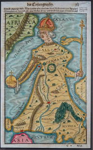
Sold2018Europa regina in Sebastian Münster's "CosmographiaEuropa regina in Sebastian Münster's "Cosmographia" framed leaf. Circa 16th/17th century. Measures 11.25" x 7" sight size. Professionally framed, appears to be in good condition. Not inspected out ofSee Sold Price
Sold2024Painting, Vopel map of 16th Century WorldEuropean School (18th/19th century), Vopel map of 16th century world after Gaspar Vopellio Medeburgense, oil on burlap, unsigned, burlap (unframed): 26”h x 68”w. Provenance: Estate of MeriSee Sold Price
Sold2023OVERSIZED REPRODUCTION OF A 16TH C. MAPMonumental and highly decorative offset lithograph reproduction map of the world by Giovanni Marfei after Abraham Ortelius, originally published c. 1589 or 1593. Dimensions: (Frame) H 45" x W 84" CondSee Sold Price
Sold202216th C. Woodcut Ptolemy Maps by Lorenz Fries (4)**Originally Listed At $800** Lorenz (Laurent) Fries (ca. 1485-1532). Published in Geographia of Claudius Ptolemy (Claudius Ptolemaeus, after 83-ca. 168 CE), 1541. Four Ptolemaic maps, all woodblocksSee Sold Price
Sold2018Munster: Antique Ptolemaic Map of British Isles, 1570Title: Britannischen Insula. 1570 woodcut Ptolemaic map of the British Isles Map maker: Sebastian Münster Place and Year: Basel, 1570 Dimensions: 25.0 x 16.5 cm (9.8 x 6.5 in) Technique: Woodblock prSee Sold Price
Sold2022Map of Paris 1576Map of Paris French Munster copy of 16th Century Walled City Framed Great Graphics & Really Interesting Map print not engraving Great Vintage Condition Measuring 18" x 17" Out of New York City EstateSee Sold Price
Sold2020MÜNSTER, SEBASTIAN. Die Erst General Tafel / DieMÜNSTER, SEBASTIAN. Die Erst General Tafel / Die Beschreibung und den Circkel des Gantzen Erdtrichs und Deers Innhaltende. Double-page woodcut map of the world within a foliate border design. 14xSee Sold Price
Sold2016Munster DES NOUVELLES ISLES. Woodcut map.[New World] DES NOUVELLES ISLES, COMMENT, QUAND & PAR QUI ELLES ONT ESTE TROUVEES. Woodcut map from Sebastian Munster’s “Cosmographia…” Text below woodcut and on verso. Several French editionsSee Sold Price
Sold2023MAP, Germany, MunsterSouthern Germany. Sebastian Munster, Das Algow, from Cosmographey oder Beschreibung Aller Laender, 1578 (published). Hand Color. This charming woodblock map of southwestern Bavaria oriented with northSee Sold Price
Sold2024MAP, Balkans, MunsterIstria Peninsula, Croatia. Sebastian Munster, [Title on Verso] Hysterreich, from Cosmographei oder Beschreibung aller Länder, 1556 (published). Hand Color. Woodblock map of Istria, in present-day CroSee Sold Price
Sold2018Münster, Sebastian. Book Leaf With Map of Cyprusfrom Von Den Landern Asie,16th century, copperplate engraving, quarto, German text. Presented in painted carved wooden frame. DOA 19.75 x 15 5/8 in. A Single-Owner Collection of Cypriot History & CultSee Sold Price
Sold201716TH C. MAP OF NEW GUINEA16th Century map of the coast identifying Sierra Leone by the Portuguese. Dimensions: (Frame) H 19.5" x W 23.75" (Sight) H 13.75" x W 19.5" Condition: Foxing to mat. Wear to frame.See Sold Price
Sold202216TH C. MAP OF AMSTERDAM BY BRAUN & HOGENBERG"Amstelredamum, Nobile Inferioris Germaniae Oppidum (..)" by Frans Hogenberg (1535-1590) / Georg Braun (1541-1622). Handcolored copperplate engraving, perspective map with buildings, from the first paSee Sold Price
Sold2024LATE 16TH C. MAP OF SCOTLAND BY MERCATOR, FRAMEDSouthern Scotland, from Mercator's Atlas "sive Cosmographicae Meditationes de Fabrica Mundi" (Duisberg, ca 1595), copperplate engraving on wove paper, with handcoloring, center fold as issued. In goldSee Sold Price
4 days LeftJasper521756 Mexican port of Zihuatanejo, also known as Chequetan or Seguatanco, was depicted by the English$20
4 days LeftJasper521753 Prevost Map of Pacific Wind Currents -- Representation du Cours ordinaire des Vents de Traverse$85
Featured4 days LeftJasper521756 The Remote Chilean Juan Fernandez Archipelago, Eastern Robinson Crusoe Island, by G. Anson$20
4 days LeftJasper521846 Quin Map of the Mediterranean and Persia During the Rule of Cyrus -- Fourth period : B.C. 529.$55


![World.- Münster (Sebastian) Figura del Mondo Universale, [c. 1575].: World.- Münster (Sebastian) Figura del Mondo Universale, Ptolemaic woodcut map of the ancient world, prior to the discovery of the New World with an enclosed Indian Ocean and multiple lake source](https://p1.liveauctioneers.com/5458/260724/135800515_1_x.jpg?height=310&quality=70&version=1662479034)


![Munster DES NOUVELLES ISLES. Woodcut map.: [New World] DES NOUVELLES ISLES, COMMENT, QUAND & PAR QUI ELLES ONT ESTE TROUVEES. Woodcut map from Sebastian Munster’s “Cosmographia…” Text below woodcut and on verso. Several French editions](https://p1.liveauctioneers.com/179/85723/44107983_1_x.jpg?height=310&quality=70&version=1456876561)

![MAP, Balkans, Munster: Istria Peninsula, Croatia. Sebastian Munster, [Title on Verso] Hysterreich, from Cosmographei oder Beschreibung aller Länder, 1556 (published). Hand Color. Woodblock map of Istria, in present-day Cro](https://p1.liveauctioneers.com/6576/320593/172252548_1_x.jpg?height=310&quality=70&version=1708729193)


