Sold201713 1859 U.S. Coastal Survey MapsDESCRIPTION: Collection of thirteen 1859 United States coastal survey maps from a trigonometrical survey. Includes: St. Mary's River, Maryland; New York Bay and Hudson River; Port Royal Entrance of SoSee Sold Price
Sold2016Canada.- Jefferys (Thomas) - An Authentic Plan of thewith the Operations of the Siege of Quebec , with inset map showing part of the Upper River of St. Laurence, and an inset View of the Action gained by the English Sep. 13th 1759, engraved map, 340 x 5See Sold Price
Sold2020W. Marshall- AtlasMarshall, W. L.- ''Atlas Containing Maps of Chicago River, Illinois and Its Branches, Showing Result of Improvement by the U.S Government Under Direction of Major W.L. Marshall''- Corps of Engineers USee Sold Price
Sold2020St. Mary's River and Fernandina Harbor Florida... 1857.Title: St. Mary's River and Fernandina Harbor Florida... 1857. Resurvey of Bar by C.O. Boutelle Asst. in 1862. Publication Date: 1863 Cartographer: HARRISON, A.M./C.O. BOUTELLE Publisher: U.S. COAST SSee Sold Price
Sold2023U S Coast Survey 1856 Large Map. St. Mary's Bar & Fernandina Harbor Florida"Preliminary Chart of St. Mary's Bar and Fernandina Harbor Florida"Large Lithograph Map Published 1857, Washington for "U.S. Coast and Geodetic Survey" Folds as issued. Paper Size: 25 x 23 inch (64 xSee Sold Price
Sold2024FINELY PAINTED RUSSIAN ICON SHOWING ST. MARY OF EGYPT WITH SCENES OF HER LIFEaround 1800 31 x 25 cmSee Sold Price
Sold2016A RARE ICON SHOWING ST. MARY OF RADONEZH WITHIN A KYOTA RARE ICON SHOWING ST. MARY OF RADONEZH WITHIN A KYOT Russian, circa 1900 Oil (?) on wood with velvet backing. The saint is portrayed frontally half-length. She is wearing monkish attire, notably theSee Sold Price
Sold2022FULLER, CAPTAIN WILLIAM; JEFFERYS, THOMAS; and DE BRAHM, WILLIAM GERARD Plan of Amelia Island inFULLER, CAPTAIN WILLIAM; JEFFERYS, THOMAS; and DE BRAHM, WILLIAM GERARD Plan of Amelia Island in East Florida [and] A Chart of the Entrance into St. Mary's River...[and] A Chart of the Mouth of NassauSee Sold Price
Sold2021PAIR OF NATIVE AMERICAN MOCCASINS.Blackfoot, ca. 1915. Thread and sinew sewn beaded mocassins with floral designs. MInimal wear. 9.5"l. A note states they were purchased by Edwin C. Hasse while working on the St. Mary's River dam, BabSee Sold Price
Sold2019General Map of South AmericaReserve Reduced! Title: General Map of South America Publication Date: 1794 Cartographer: RUSSELL, J. Publisher: H.D. SYMONDS Size: 14.25 x 17.75 "drawn from the best surveys..." Good map showing riveSee Sold Price
Sold20191848 S. Breese Rail Road and Seaboard Map"Skeleton map showing the Rail Roads completed and in progress in the United States, and those projected through the Public Lands and their connection with the principal harbours on the Lakes and on tSee Sold Price
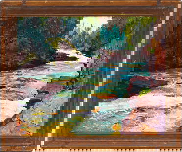
Sold2024Wilma Lucile Van Slyck Western Landscape, Glacier National ParkWilma Lucile Van Slyck (Ohio, 1898-1982), oil on panel painting depicting the St. Mary River in Glacier National Park, flowing through boulders surrounded by evergreens. Signed lower right: "L Van SlySee Sold Price
Sold20186 Maps incl: Seutter. Majestas Austriaca...[Austria/DC/Ancient World] 6 Maps. ++ Matthaus Seutter. Majestas Austriaca… C. 1730s-1740s. Detailed map showing rivers and towns in Austria. Hand colored. Border: 19 1/8 x 22 in. Frame: 30 1/2 x 35See Sold Price
Sold20201757 Bellin Map St Lawrence River CanadaCarte Du Cours Du Fleuve de St. Laurent..:, printed by Jacques Bellin in 1757, Paris. Shows portion of the Saint Lawrence River including Quebec. Fine, measures 13.75 x 9.5. Reserve: $100.00 Shipping:See Sold Price
Sold2022[MANUSCRIPT MAP-FLORIDA & MISSISSIPPI RIVER] Map Showing Raiford's Proposed Artificial River and[MANUSCRIPT MAP-FLORIDA & MISSISSIPPI RIVER] Map Showing Raiford's Proposed Artificial River and Plan to Continue the Western and Southern Inland System of Navigation to Harbors in the Atlantic. [FernSee Sold Price
Sold20201760 Bellin Map of St Lawrence RiverEngraved map of Jacques Bellin circa 1752 entitled "Suite Du Cours Du Fleuve De St. Laurent Depuis Quebec jusqu u Lac Ontario" from his work "L'Historie Generale des voyages". Printed at Paris measureSee Sold Price
Sold2022Belgium.- Ortelius (Abraham) Leodiensis DioecesisBelgium.- Ortelius (Abraham) Leodiensis Dioecesis Typus, map showing the Muese River valley including Namur and Liege, with west oriented at top of map, engraving with full hand-colouring, platemark 3See Sold Price
Sold2017Bellin: Antique Map of Canada's St Laurence River, 1740Title/Content of Map: Canada's St. Laurence river region by Bellin Date Printed: c 1740-70's Cartographer: J.N. Bellin & J.F. La Harpe Material/Medium: Paper Size: 14" x10" Copperplate engraved. PubliSee Sold Price
Sold2020Anson, George C1750 Pair of LG Prints. ArgentinaBoth showing the St. Julian River. Folio Copper Plates Published C1750, London for "A Voyage Round the World in the Years MDCCXL, I, II, III, IV." by George Anson. Folds as issued. Paper Size: 18.5 xSee Sold Price
Sold20181872 Asher & Adams Map of Europe -- Asher and Adams'Title/Content of Map: 1872 Asher & Adams Map of Europe -- Asher and Adams' Europe Date: 1872, New York Cartographer: Asher & Adams Size: 16 X 23 in. An attractive map of Europe showing rivers, lakes,See Sold Price
Sold2018Automobile Road Map of WisconsinTitle: Automobile Road Map of Wisconsin Publication Date: 1937 Cartographer: W.W. HIXSON & CO. Publisher: W.W. HIXSON & CO. Size: 25.5X20.8 Map showing counties, towns, rivers & creeks and shows all hSee Sold Price
Sold2016Sailing the Great Lakes 1874Heading: Author: Disturnell, John Title: Sailing On The Great Lakes and Rivers Of America; embracing a description of Lakes Erie, Huron, Michigan & Superior, and Rivers St. Mary, St. Clair, Detroit,See Sold Price
Sold2017Lee: Antique Map of St. Louis & Mississippi River, 1837Map: 1837 Lee Map of St. Louis and Mississippi River -- No.3. Map of the Harbor of St. Louis, Mississippi River. Oct. 1837 Cartographer: R E Lee Year / Place: 1837, Washington Map Dimensions: 16 x 41See Sold Price
Sold2017Thomson: Antique Map of U.S. / St. Lawrence River, 1817Map: The Course of the River St. Laurence/United States of America Cartographer: Thomson Place & Date: Edinburgh / 1817 Size: 24 1/4" x 16 1/8" Condition: overprinting and light age-toning throughout;See Sold Price
2 days LeftJasper521653 Blaeau Map of the Dnieper River -- Lectori S. Hunc Borysthenis Tractum ut ad Nostrum$850
Featured2 days LeftJasper521645 Jansson Map of Portugal and Parts of Spain -- Portugallia et Algarbia quae olim Lusitania$200
3 days LeftA.H. Wilkens Auctions & AppraisalsJEFFERYS. AN EXACT CHART OF THE RIVER ST. LAURENCECA$200(1 bid)
1 day LeftFreeman's | Hindman[Native-Americana] Bodmer, Karl: Cave-In-Rock. view on the Ohio$250(1 bid)
2 days LeftJasper521874 Holmes Plan of New York's Upper East Side -- Map of the Common Lands from 76th to 93rd Street$750
2 days LeftJasper521700 Schenk Map of Russian Empire -- La Russie Blanche ou Moscovie Divisee Suivant l'Estendue des$240
Featured2 days LeftJasper521702 Homann Map of Northern Italy, Milan Included -- Belli Typus in Italia…$160
5 days LeftGalerie Moenius AGRARE RUSSIAN ICON WITH SILVER OKLAD SHOWING ST. ALEXANDER KUSHTSKYCHF 300


![FULLER, CAPTAIN WILLIAM; JEFFERYS, THOMAS; and DE BRAHM, WILLIAM GERARD Plan of Amelia Island in: FULLER, CAPTAIN WILLIAM; JEFFERYS, THOMAS; and DE BRAHM, WILLIAM GERARD Plan of Amelia Island in East Florida [and] A Chart of the Entrance into St. Mary's River...[and] A Chart of the Mouth of Nassau](https://p1.liveauctioneers.com/292/250642/130213561_1_x.jpg?height=310&quality=70&version=1654271664)


![6 Maps incl: Seutter. Majestas Austriaca...: [Austria/DC/Ancient World] 6 Maps. ++ Matthaus Seutter. Majestas Austriaca… C. 1730s-1740s. Detailed map showing rivers and towns in Austria. Hand colored. Border: 19 1/8 x 22 in. Frame: 30 1/2 x 35](https://p1.liveauctioneers.com/179/122672/62428327_1_x.jpg?height=310&quality=70&version=1527272450)

![[MANUSCRIPT MAP-FLORIDA & MISSISSIPPI RIVER] Map Showing Raiford's Proposed Artificial River and: [MANUSCRIPT MAP-FLORIDA & MISSISSIPPI RIVER] Map Showing Raiford's Proposed Artificial River and Plan to Continue the Western and Southern Inland System of Navigation to Harbors in the Atlantic. [Fern](https://p1.liveauctioneers.com/292/250642/130213644_1_x.jpg?height=310&quality=70&version=1654271664)


![[MAPS - LOUISIANA]. Map of Louisiana from D'Anville's Atlas. London, 1788. (1 of 0)](https://p1.liveauctioneers.com/dist/images/placeholder.jpg?height=282&quality=70)

![[Native-Americana] Bodmer, Karl: Cave-In-Rock. view on the Ohio (1 of 1)](https://p1.liveauctioneers.com/65/332523/179335179_1_x.jpg?height=282&quality=70&version=1717622830)


