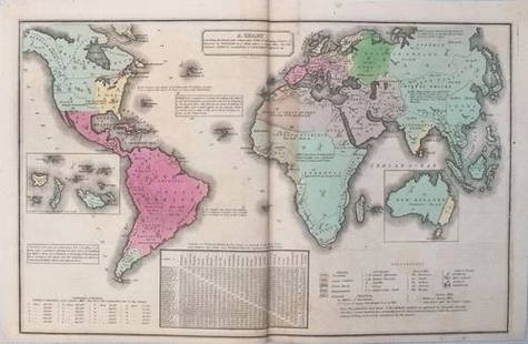
Sold2017Smith: Antique Map of the World, 1835Map: 1835 Smith World Map -- A Chart Exhibiting the Actual and Comparative Size of each Country, Nation, or Kingdom; its Population as a Whole and to a Square Mile. Also the Different States of SocietSee Sold Price
Sold20211835 Smith World Map -- A Chart Exhibiting the ActualTitle: 1835 Smith World Map -- A Chart Exhibiting the Actual and Comparative Size of each Country, Nation, or Kingdom; its Population as a Whole and to a Square Mile. Also the Different States of SociSee Sold Price
Sold2018Smith/Burgess: Antique Map of Africa, 1835Title/Content of Map: 1835 Smith/Burgess Map of Africa -- Africa Date Printed: 1835, Hartford Cartographer: C Smith / D Burgess Size: 8.7 x 10.4 in. This is a very nice map of Africa from the early 19See Sold Price
Sold2021Barlow 1807 Antique Map. World HemispheresCopper Engraved Map Published 1807 by Brightly & Kinnersley, Bungay, England for "A General View of the World, Geographical, Historical and Philosophical" by The Rev. E. Blomfield. Engraved by Barlow.See Sold Price
Sold2017Jamaica British West Indies Antique Map, 1835Map: Jamaica British West Indies Antique Map Size: 15.5"W × 0.1"D × 13.0"H Year: 1835 Please note that this lot has a confidential reserve. When you leave a bid in advance of the auction, submit youSee Sold Price
Sold2017Smith: Antique Map of Asia, 1894Map: 1894 Smith Map of Asia [verso] South Central Europe -- Map of Asia Showing its Geopolitical Divisions, and also the Various Routes of Travel between London & India, China & Japan &c. [verso] AustSee Sold Price
Sold2018Smith: Antique Map of South America, 1894Title/Content of Map: 1894 Smith Map of South America [verso] Columbia, Venezuala, Peru, Equador, Argentina -- Map of South America Showing its Political Divisions [verso] Map of U.S. of Columbia VeneSee Sold Price
Sold2023Brookes & Baker 1797 Antique Map. World HemispheresCopper Engraved Map Published 1797, London for "The General Gazetteer; Or, Compendious Geographical Dictionary" by Richard Brookes. Engraved by B. Baker. Original outline hand colour. Folds as issued.See Sold Price
Sold2023Becker, F. P. C1845 Antique Map. World on Mercators ProjectionSteel Engraved Map Published C1845, London for "A Complete and Universal English Dictionary" by the Rev. James Barclay and B. B. Woodward. Maps by F. P. Becker. Outline hand color. Paper Size: 11 x 8See Sold Price
Sold2023Brookes, Richard 1791 Antique Map. World HemispheresCopper Engraved Map Published 1791, London for "The General Gazetteer; Or, Compendious Geographical Dictionary" by Richard Brookes. Folds as issued. Paper Size: 12 x 8 inch (31 x 21cm) A few small marSee Sold Price
Sold2024Russell, J. 1804 Antique Map. World HemispheresCopper Engraved Map with outline hand color Published 1804 by W. Peacock, London for "A Compendious Geographical Dictionary" Drawn and Engraved by J. Russell. Folds as issued. Paper Size: 6.5 x 5 inchSee Sold Price
Sold2020Becker, F. C1838 Antique Map. World on Mercator's Proj.Steel Engraved Map with outline hand color Published C1838, London for "A Complete and Universal English Dictionary" by the Rev. James Barclay et al. Maps by F. Becker and others. Paper Size: 10.5 x 8See Sold Price
Sold2020Becker, F. C1850 Antique Map. World on Mercator's Proj.Steel Engraved Map with outline hand color Published C1850 "A Complete and Universal English Dictionary" by the Rev. James Barclay et al. Maps by F. Becker and others. Paper Size: 10.5 x 8 inch (27 xSee Sold Price
Sold2022Rapkin, John 1860 Antique Map. World HemispheresSteel Engraved Map Published 1860 by The London Printing & Published Company, London for "The Royal Dictionary-Cyclopedia for Universal Reference" by Thomas Wright. Drawn & Engraved by John Rapkin. FoSee Sold Price
Sold2023Vyse, Charles 1805 Antique Map. World HemipsheresCopper Engraved Map Published 1805 (Map dated 1799) London for "Geography for Youth. A New Grammar: Containing A Comprehensive System of Modern Geography…" by Charles Vyse. Folds as issued, Paper SiSee Sold Price
Sold2022Brewster, David 1830 Antique Map. World on Mercator's Projection"Charte of the World on Mercator's Projection with the dip and variation of the Compass. The Trade Winds & Monsoons" Copper Engraved Map Published 1808-1830, Edinburgh for "The Edinburgh EncyclopaediaSee Sold Price
Sold2023Barclay & Milton C1810 Antique Map. World HemispheresCopper Engraved Map Published C1810, London for "Barclay's Universal Dictionary" by James Barclay. Original outline hand colour. Maps Engraved by W. Milton. Paper Size: 17 x 10.5 inch (43 x 27cm) MinoSee Sold Price
Sold2023Walker, John C1805 Antique Map. World HemispheresCopper Engraved Map Published C1805, London for "The Universal Gazetteer: Being a Concise Description" [Walker's Geography] by John Walker. Folds as issued. Paper Size: 13.5 x 8 inch (35 x 20cm) SomeSee Sold Price
Sold2022Brewster, David 1830 Antique Map. World HemipsheresCopper Engraved Map Published 1808-1830, Edinburgh for "The Edinburgh Encyclopaedia" Conducted by David Brewster. Folds as issued. Paper Size: 17 x 10.5 inch (43 x 27cm) Very minor background toning/oSee Sold Price
Sold2022Nat. Encyclo. 1891 Antique Map. World HemispheresLithograph Map Published 1891-1901 by William Mackenzie, London for "The National Encyclopedia: A dictionary of Universal Knowledge" Centre Fold as issued. Paper Size: 12 x 9.5 inch (31 x 24cm) Good CSee Sold Price
Sold2017Desnos/de la Tour: Antique Map of World in HemispheresTitle/Content of Map: 'Mappe-Monde, dressée pour l'etude de la Géographie, rélativement aux auteurs les plus modernes. Revûë, corrigée et augmentée d'apres les Nouvelles Observations AstronomiqSee Sold Price
Sold2017Smith: Antique Railroad Map of the United States, 1855Map: Map of the United States of America, Showing the Rail Roads. Large, Colorful Railroad Map of U.S. 1855 Publication Date: 1855 Authors: HARPER & BROTHERS, SMITH, J. CALVIN / D. MCLELLAN Publisher:See Sold Price
Sold2018Moll: Antique Map of World Trade Winds, 1746Title/Content of Map: World Trade Winds by Moll Date Printed: 1746 Cartographer: Thomas Salmom & Herman Moll Material/Medium: Paper Size: 20 1/2" x 9 1/4" Copperplate engraved. Published in London inSee Sold Price
Sold2017Bonne: Antique Map of World on Mercator's ProjectionTitle/Content of Map: 'Planisphere suivant la Projection de Mercator' A map of the world on Mercator's projection, showing the trade winds Date Printed: 1780 Image Size: Approx 23.0 x 35.0cm, 9 x 13.7See Sold Price


![Smith: Antique Map of Asia, 1894: Map: 1894 Smith Map of Asia [verso] South Central Europe -- Map of Asia Showing its Geopolitical Divisions, and also the Various Routes of Travel between London & India, China & Japan &c. [verso] Aust](https://p1.liveauctioneers.com/5584/108292/55552449_1_x.jpg?height=310&quality=70&version=1503667951)
![Smith: Antique Map of South America, 1894: Title/Content of Map: 1894 Smith Map of South America [verso] Columbia, Venezuala, Peru, Equador, Argentina -- Map of South America Showing its Political Divisions [verso] Map of U.S. of Columbia Vene](https://p1.liveauctioneers.com/5584/115725/59466841_1_x.jpg?height=310&quality=70&version=1517366277)


![Walker, John C1805 Antique Map. World Hemispheres: Copper Engraved Map Published C1805, London for "The Universal Gazetteer: Being a Concise Description" [Walker's Geography] by John Walker. Folds as issued. Paper Size: 13.5 x 8 inch (35 x 20cm) Some](https://p1.liveauctioneers.com/3952/311930/166897808_1_x.jpg?height=310&quality=70&version=1701713718)


