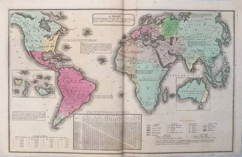
Sold2017Smith: Antique Map of the World, 1835Map: 1835 Smith World Map -- A Chart Exhibiting the Actual and Comparative Size of each Country, Nation, or Kingdom; its Population as a Whole and to a Square Mile. Also the Different States of SocietSee Sold Price
Sold20211835 Smith World Map -- A Chart Exhibiting the ActualTitle: 1835 Smith World Map -- A Chart Exhibiting the Actual and Comparative Size of each Country, Nation, or Kingdom; its Population as a Whole and to a Square Mile. Also the Different States of SociSee Sold Price
Sold2018Smith/Burgess: Antique Map of Africa, 1835Title/Content of Map: 1835 Smith/Burgess Map of Africa -- Africa Date Printed: 1835, Hartford Cartographer: C Smith / D Burgess Size: 8.7 x 10.4 in. This is a very nice map of Africa from the early 19See Sold Price
2018Covens and Mortier: Antique World Map, 1745Title/Content of Map: 1745 Covens and Mortier World Map -- Mappe-Monde Dressee sur les Observations de Mrs. de l'Academie Royale des Sciences et Quelques Autres et sur les Memoires les Plus Recens DatSee Sold Price
Sold2017Chatelain: Double Hemisphere Antique World Map, 1705Map: Mappemonde ou Description General du Globe Terrestre Cartographer: Henri Chatelain Place & Date: Amsterdam / 1705 Size: 17 1/4" x 13 1/4" Condition: wash color; overall age toning, repaired splitSee Sold Price
Sold2021VINTAGE GOLD FOIL 1630 ANTIQUE WORLD MAPVINTAGE GOLD FOIL 1630 ANTIQUE WORLD MAP "Nova Totius Terrarum Orbis Geographica Ac Hydrographica TAbvla" Print, Framed. Size: 23 X 19 inches. Private Collection.See Sold Price
Sold2023FRAMED ANTIQUE WORLD MAP BY PETER APIAN - 1520Description: FRAMED ANTIQUE WORLD MAP BY PETER APIAN - 1520Measurement approximate:Material: PaperSee Sold Price
Sold2017Rand McNally: Antique World Map, Rivers & MountainsMap: Rand McNally World Map and Comperative Chart of Rivers and Mountains -- The World on Mercator's Projection [verso] Western Hemisphere Cartographer: Rand McNally Year / Place: 1898, Chicago Map DiSee Sold Price
Sold2022Antique World Map - Colored Etching Pre 1775World Map. Due to laid paper technique, we believe it may be pre-1775. This map is based on the 1594 world map by Peter Plancius, but what draws the eye are the lively figures depicted in the corner sSee Sold Price
Sold2017Mitchell: Multi-Projection Antique World Map, 1867Map: The World in Hemispheres with Other Projections Cartographer: S. A. Mitchell Place & Date: Philadelphia / 1867/1870 Size: 13" x 11 1/4" Condition: wash color; overall age toning; nicks and frayinSee Sold Price
Sold2017Mitchell: Mercator Projection Antique World Map, 1867Map: Map of the World on the Mercator Projection Cartographer: S. A. Mitchell Place & Date: Philadelphia / 1867/1870 Size: 17 3/4" x 14" Condition: full color; light overall age toning; some spottingSee Sold Price
Sold2017Jamaica British West Indies Antique Map, 1835Map: Jamaica British West Indies Antique Map Size: 15.5"W × 0.1"D × 13.0"H Year: 1835 Please note that this lot has a confidential reserve. When you leave a bid in advance of the auction, submit youSee Sold Price
Sold2021Antique World Map 1826Antique World Map. Size: 11 X 16 inches approx. Unframed. Printed Circa 1826. Centerfold as issued.See Sold Price
Sold2017Smith: Antique Map of Asia, 1894Map: 1894 Smith Map of Asia [verso] South Central Europe -- Map of Asia Showing its Geopolitical Divisions, and also the Various Routes of Travel between London & India, China & Japan &c. [verso] AustSee Sold Price
Sold2018Smith: Antique Map of South America, 1894Title/Content of Map: 1894 Smith Map of South America [verso] Columbia, Venezuala, Peru, Equador, Argentina -- Map of South America Showing its Political Divisions [verso] Map of U.S. of Columbia VeneSee Sold Price
Sold2017Thomson: Antique World Map, Mercator's Projection, 1814Map: Chart of the World on Mercator's Projection Cartographer: Thomson Place & Date: Edinburgh / 1814 Size: 20" x 17 3/4" Condition: b&w; overall age toning; browning along centerfold; two small, repaSee Sold Price
Sold2022ANTIQUE WORLD MAPS AND AMERICAN HISTORY BOOKSA lot of eight antique and vintage historical books and maps. Arbuckles Illustrated Atlas of Fifty Principal Nations of the World, 1890. Lois Marie Hunter, The Shinnecock Indians, 1960. Replogle WorldSee Sold Price
Sold2017Chart of the World on Mercators ProjectionCirca 1796 Lot of 2 Antique World Maps; Titles: "Chart of the World on Mercators Projection" (Doolittle, sculp.) Approximate size: 11" x 8-3/8". "Map of the World from the best Authorities" (DoolittleSee Sold Price
Sold2017Brue: Antique Map of the World; East & West HemispheresMap: Large antique world map of the east and west hemispheres Publication Date: 1822 Creator: Brue, Adrien Hubert Size: 26 x 15 Coloring: Outline hand-coloring Conditoin: Very good. Wide margins. A feSee Sold Price
Sold2021(2) ANTIQUE FRAMED MAPSAntique world map approximately 16" x 9.75" w/ frame and Asia minor 11.75" x 9.25" w/ frame.See Sold Price
Sold2023Antique Print - World - Map of the World in Hemispheres - Philipp Cluver - 1701Title: Antique Print - World - Map of the World in Hemispheres - Philipp Cluver - 1701 Date: 1701 Material: Paper Dimensions: 27 cm x 13 cm Description: A detailed small map from ”IntroductionisSee Sold Price
Sold2017Smith: Antique Railroad Map of the United States, 1855Map: Map of the United States of America, Showing the Rail Roads. Large, Colorful Railroad Map of U.S. 1855 Publication Date: 1855 Authors: HARPER & BROTHERS, SMITH, J. CALVIN / D. MCLELLAN Publisher:See Sold Price
Sold2023Antique Western World Map From Dampier's ExplorationsMap of Western World engraving on paper Dampiers Explorations 13 x 18 inches (unframed) William Dampier was an English explorer, navigator, and pirate who lived from 1651 to 1715. He is best known forSee Sold Price
Sold2021Neele, J. 1834 Antique World Hemisphere MapSteel Engraved Map Published 1834, London for "The Universal Preceptor; or, General Grammar..." by the Rev. David Blair. Engraved by J. Neele. Folds as issued. Paper Size: 10.5 x 5.5 inch (27 x 14cm)See Sold Price
4 days LeftJasper52Bahamas harbours Pelican Abaco Berry I Jumentos ADMIRALTY chart 1899 (1920) map$140
4 days LeftJasper52BRITISH WEST INDIES. Jamaica Antilles Virgin Cayman Islands. SDUK 1844 old map$150
4 days LeftJasper52BRITISH WEST INDIES Jamaica Trindad Antilles Virgin Cayman Islands SDUK 1844 map$150
3 days LeftJasper52Coastline of Cape Blanco, Patagonia, Argentina by Pirate G. Anson (1756)$20(1 bid)


![Rand McNally: Antique World Map, Rivers & Mountains: Map: Rand McNally World Map and Comperative Chart of Rivers and Mountains -- The World on Mercator's Projection [verso] Western Hemisphere Cartographer: Rand McNally Year / Place: 1898, Chicago Map Di](https://p1.liveauctioneers.com/5584/108569/55677982_1_x.jpg?height=310&quality=70&version=1504123318)


![Smith: Antique Map of Asia, 1894: Map: 1894 Smith Map of Asia [verso] South Central Europe -- Map of Asia Showing its Geopolitical Divisions, and also the Various Routes of Travel between London & India, China & Japan &c. [verso] Aust](https://p1.liveauctioneers.com/5584/108292/55552449_1_x.jpg?height=310&quality=70&version=1503667951)
![Smith: Antique Map of South America, 1894: Title/Content of Map: 1894 Smith Map of South America [verso] Columbia, Venezuala, Peru, Equador, Argentina -- Map of South America Showing its Political Divisions [verso] Map of U.S. of Columbia Vene](https://p1.liveauctioneers.com/5584/115725/59466841_1_x.jpg?height=310&quality=70&version=1517366277)


