Sold2022Uncommon Texas/Indian Territory RR map, 1890Unusual map of Texas and Indian Territory by McNally showing highly detailed picture of Native American tribe locations in Indian Territory. Presents a thorough overview of railroad lines in the regioSee Sold Price
Sold20211873 Texas and Indian Territory MapAuthor: Bartholomew Title: 1873 Texas and Indian Territory Map Medium: Ink on Paper Dimensions: 17.5"X13" Map of Texas and the Indian Territory dated 1873. Part of Zell's Descriptive Hand Atlas of theSee Sold Price
Sold20211880 Gray Map of Texas and Indian Territory -- Gray'sTitle: 1880 Gray Map of Texas and Indian Territory -- Gray's New Map of Texas and the Indian Territory Cartographer: F Gray Year/Place: 1880, Philadelphia Map Dimensions (in.): 17 X 26.4 in. DescriptiSee Sold Price
Sold20171882 Historical Hand Atlas, H. H. Hardesty Map1882 Historical Hand Atlas Illustrated, H. H. Hardesty 11.5 X 15. This Hard-to-find Atlas Has Been Rebound—it Will Look Great on Your Shelf. Several State Maps (texas/indian Territory, California/laSee Sold Price
Sold20211869 McNally Map of Texas, Indian Territory and NewTitle: 1869 McNally Map of Texas, Indian Territory and New Mexico -- Texas, New Mexico, and Indian Territory Cartographer: F McNally Year / Place: 1869, New York Map Dimension (in.): 8.3 X 10.6 in. ThSee Sold Price
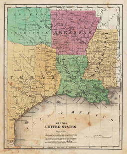
Sold2017Fullarton: Antique Map of Texas & Indian Territory 1860Map: 1860 Fullarton Map of Texas (East/Central), Indian Territory, Louisiana and Arkansas -- United States North America According to Calvin Smith& Tanner . . . South Central Section. Comprising TexasSee Sold Price
Sold2017Cram: Antique Map of Texas, Indian Territory, ArkansasTitle/Content of Map: 1885 Cram Map of Texas, [verso] Indian Territory and Arkansas -- Texas, [verso] Indian Ty; Arkansas Date Printed: 1885, Chicago Cartographer: G Cram Size: 12 x 17 in. This is a nSee Sold Price
Sold2017Rand McNally: Antique Map of Texas & Indian TerritoryMap: 1895 Rand McNally Map of Texas and Indian Territory/Oklahoma -- Texas; Oklahoma and Indian Territory Cartographer: Rand McNally Year / Place: 1895 Chicago Map Dimensions: 9.2 x 12.5 in. ConditionSee Sold Price
Sold2017Rand McNally: Antique Map of Texas & Indian TerritoryTitle/Content of Map: 1895 Rand McNally Map of Texas and Indian Territory/Oklahoma -- Texas; Oklahoma and Indian Territory Date Printed: 1895 Chicago Cartographer: Rand McNally Size: 9.2 x 12.5 in. CoSee Sold Price
Sold2019AN VINTAGE MAP, "Texas and Indian Territory," SECONDAN VINTAGE MAP, "Texas and Indian Territory," SECOND QUARTER 20TH CENTURY, color engraving on paper, showing counties, cities, rail lines, and rivers. 13.25" x 10.125"See Sold Price
Sold20211847 map showing east Texas/Indian TerritoryInteresting map of the southern U. S. in 1847. Map by Cady & Burgess from Roswell SmithÂ’s 1847 Quarto Atlas. Eastern portion of Texas shown along with most of Indian Territory. Also includes ArkanSee Sold Price
Sold20191892 Watson/Cram Map of Texas [verso] Indian TerritoryTitle/Content of Map: 1892 Watson/Cram Map of Texas [verso] Indian Territory [verso] Arkansas -- Watson's Atlas Map of Texas [verso] Watson's Atlas Map of Indiand Ty. [verso] Watson's Atlas Map of ArkSee Sold Price
Sold2019George Cram’s "Rail Road Map, Texas and IndianGeorge Cram’s "Rail Road Map, Texas and Indian Territory," 1900, H.- 18 3/8 in., W.- 26 3/4 in.See Sold Price
Sold2022Gray’s New Map of Texas and Indian Territory, 1884Impressive and huge, hand colored map of the Lone Star State with complete view of Indian Territory. Map features seven insets: (1) The River System of Texas and the Indian Territory; (2) Part of TexaSee Sold Price
Sold2021Map of Texas and Indian Territory - 1850'sMap of Texas and Indian Territory Cartographer: George Woolworth Colton Dated: C 1850's Type: Engraved Hand Colored Dimensions: 9 1/2 x 7 1/2" ConditiSee Sold Price
Sold20191886 Cram Map of Texas [verso] Indian Territory [verso]Title/Content of Map: 1886 Cram Map of Texas [verso] Indian Territory [verso] Arkansas -- Texas [verso] Indian Ty. [verso] Arkansas Date: 1882, Chicago Cartographer: G CramSize: 12 X 17 in. This is aSee Sold Price
Sold20201886 Cram Map of Texas [verso] Indian Territory [verso]Title/Content of Map: 1886 Cram Map of Texas [verso] Indian Territory [verso] Arkansas -- Texas [verso] Indian Ty. [verso] Arkansas Cartographer: G Cram /People's Publishing Co. Year/Place: 1886, ChicSee Sold Price
Sold20201887 Cram Map of Texas [verso] Indian Territory [verso]Title/Content of Map: 1887 Cram Map of Texas [verso] Indian Territory [verso] Arkansas -- Texas [verso] Indian Ty. [verso] Arkansas Date: 1887, Chicago Cartographer: G Cram Size: 12 X 17 in. This is aSee Sold Price
Sold20201886 Cram Map of Texas [verso] Indian Territory [verso]Title/Content of Map: 1886 Cram Map of Texas [verso] Indian Territory [verso] Arkansas -- Texas [verso] Indian Ty. [verso] Arkansas Date: 1886, Chicago Cartographer: G Cram Size: 12 X 17 in. This is aSee Sold Price
Sold20221886 Cram Map of Texas [verso] Indian Territory [verso] Arkansas -- Texas [verso] Indian Ty. [verso]Title: 1886 Cram Map of Texas [verso] Indian Territory [verso] Arkansas -- Texas [verso] Indian Ty. [verso] Arkansas Cartographer: G Cram Year / Place: 1886, Chicago Map Dimension (in.): 11.8 X 17 in.See Sold Price
Sold20231884 Cram Map of Texas [verso] Indian Territory [verso] Arkansas -- Texas [verso] Indian Ty. [verso]Title: 1884 Cram Map of Texas [verso] Indian Territory [verso] Arkansas -- Texas [verso] Indian Ty. [verso] Arkansas Cartographer: G Cram Year / Place: 1884, Chicago Map Dimension (in.): 11.8 X 17 in.See Sold Price
Sold20181895 Rand McNally Map of Texas and Indian TerritoryTitle/Content of Map: 1895 Rand McNally Map of Texas and Indian Territory/Oklahoma -- Texas; Oklahoma and Indian Territory Date Printed: 1895 Chicago Cartographer: Rand McNally Size: 9.2 x 12.5 in. ThSee Sold Price
Sold20241898 Rand McNally Map of Texas [verso] Indian Territory and Oklahoma -- Texas [verso] Oklahoma andTitle: 1898 Rand McNally Map of Texas [verso] Indian Territory and Oklahoma -- Texas [verso] Oklahoma and Indian Territory Cartographer: Rand McNally Year / Place: 1898, Chicago Map Dimension (in.): 9See Sold Price
Sold20181886 Cram Map of Texas [verso] Indian Territory [and]Reserve Reduced! Title/Content of Map: 1886 Cram Map of Texas [verso] Indian Territory [and] Arkansas -- Texas [verso] Indian Ty. [and] Arkansas Date: 1886, Chicago Cartographer: G Cram Size: 11.8 x 1See Sold Price
Jun 12Dan Morphy AuctionsPLATE CXIII. MAP OF INDIAN TERRITORY SHOWING DISTRIBUTION OF WOODLAND” FROM THE TWENTY-FIRST$100
Jun 07Freeman's | HindmanYOUNGBLOOD, Charles L. Adventures of... During Ten Years on the Plains. 1882. FIRST EDITION.$200
Jun 12Dan Morphy AuctionsMAP OF THE CHOCTAW NATION, INDIAN TERRITORY - COAL AND ASPHALT SEGREGATION 1903$150
Jun 12Dan Morphy AuctionsMAP OF THE CHOCTAW NATION, INDIAN TERRITORY - COAL AND ASPHALT SEGREGATION 1903$100
Jun 12Dan Morphy AuctionsINDIAN TERRITORY - DEPARTMENT OF THE INTERIOR GENERAL LAND OFFICE, C.1883$100
Jun 08Simpson Galleries, LLC.J.H. Young (1792-1870) AN AMERICAN FEDERAL PERIOD MAP, "Mitchell's Travellers Guide Through the$500
Jun 23Schilb Antiquarian Rare Books1848 Emory Military Reconnaissance 1ed California MAP Indians Texas New Mexico$2(2 bids)
7 days LeftTrillium Antique Prints & Rare BooksSanson - Map of Canada or New France with the Great Lakes$75
7 days LeftTrillium Antique Prints & Rare BooksSanson - Map of Florida (encompassing most of Southeast North America)$75
7 days LeftTrillium Antique Prints & Rare BooksSanson - Map of the British Isles (Ireland, Scotland, England)$75
5 days LeftFreeman's | HindmanSOULE, William S. (1836-1908). A group of 3 CDVs of Comanche subjects. Fort Sill, Indian Territory.$600
5 days LeftFreeman's | HindmanSOULE, William S. (1836-1908). A group of 5 CDVs of Kiowa subjects. Fort Sill, Indian Territory. Ca$1,000
5 days LeftFreeman's | Hindman[NATIVE AMERICANS]. Album containing 25 photographs of Native American subjects from Indian$1,500
Jun 02Tremont AuctionsEarly 20th century Native American Indian ledger drawing. Depiction of a brave on horseback. Ledger$300
5 days LeftFreeman's | HindmanSOULE, William S. (1836-1908). A group of 4 CDVs of Wichita and Cheyenne subjects. Fort Sill, Indian$800


![Cram: Antique Map of Texas, Indian Territory, Arkansas: Title/Content of Map: 1885 Cram Map of Texas, [verso] Indian Territory and Arkansas -- Texas, [verso] Indian Ty; Arkansas Date Printed: 1885, Chicago Cartographer: G Cram Size: 12 x 17 in. This is a n](https://p1.liveauctioneers.com/5584/113749/58452563_1_x.jpg?height=310&quality=70&version=1513734097)


![1892 Watson/Cram Map of Texas [verso] Indian Territory: Title/Content of Map: 1892 Watson/Cram Map of Texas [verso] Indian Territory [verso] Arkansas -- Watson's Atlas Map of Texas [verso] Watson's Atlas Map of Indiand Ty. [verso] Watson's Atlas Map of Ark](https://p1.liveauctioneers.com/5584/133765/67935052_1_x.jpg?height=310&quality=70&version=1546475054)


![1886 Cram Map of Texas [verso] Indian Territory [verso]: Title/Content of Map: 1886 Cram Map of Texas [verso] Indian Territory [verso] Arkansas -- Texas [verso] Indian Ty. [verso] Arkansas Date: 1882, Chicago Cartographer: G CramSize: 12 X 17 in. This is a](https://p1.liveauctioneers.com/5584/137769/69881200_1_x.jpg?height=310&quality=70&version=1552435690)
![1886 Cram Map of Texas [verso] Indian Territory [verso]: Title/Content of Map: 1886 Cram Map of Texas [verso] Indian Territory [verso] Arkansas -- Texas [verso] Indian Ty. [verso] Arkansas Cartographer: G Cram /People's Publishing Co. Year/Place: 1886, Chic](https://p1.liveauctioneers.com/5584/175972/88577718_1_x.jpg?height=310&quality=70&version=1597183226)
![1887 Cram Map of Texas [verso] Indian Territory [verso]: Title/Content of Map: 1887 Cram Map of Texas [verso] Indian Territory [verso] Arkansas -- Texas [verso] Indian Ty. [verso] Arkansas Date: 1887, Chicago Cartographer: G Cram Size: 12 X 17 in. This is a](https://p1.liveauctioneers.com/5584/164510/83043299_1_x.jpg?height=310&quality=70&version=1585094571)
![1886 Cram Map of Texas [verso] Indian Territory [verso]: Title/Content of Map: 1886 Cram Map of Texas [verso] Indian Territory [verso] Arkansas -- Texas [verso] Indian Ty. [verso] Arkansas Date: 1886, Chicago Cartographer: G Cram Size: 12 X 17 in. This is a](https://p1.liveauctioneers.com/5584/161241/81395745_1_x.jpg?height=310&quality=70&version=1581460166)
![1886 Cram Map of Texas [verso] Indian Territory [verso] Arkansas -- Texas [verso] Indian Ty. [verso]: Title: 1886 Cram Map of Texas [verso] Indian Territory [verso] Arkansas -- Texas [verso] Indian Ty. [verso] Arkansas Cartographer: G Cram Year / Place: 1886, Chicago Map Dimension (in.): 11.8 X 17 in.](https://p1.liveauctioneers.com/5584/270923/141842451_1_x.jpg?height=310&quality=70&version=1670433092)
![1884 Cram Map of Texas [verso] Indian Territory [verso] Arkansas -- Texas [verso] Indian Ty. [verso]: Title: 1884 Cram Map of Texas [verso] Indian Territory [verso] Arkansas -- Texas [verso] Indian Ty. [verso] Arkansas Cartographer: G Cram Year / Place: 1884, Chicago Map Dimension (in.): 11.8 X 17 in.](https://p1.liveauctioneers.com/5584/304136/162284641_1_x.jpg?height=310&quality=70&version=1696356363)

![1898 Rand McNally Map of Texas [verso] Indian Territory and Oklahoma -- Texas [verso] Oklahoma and: Title: 1898 Rand McNally Map of Texas [verso] Indian Territory and Oklahoma -- Texas [verso] Oklahoma and Indian Territory Cartographer: Rand McNally Year / Place: 1898, Chicago Map Dimension (in.): 9](https://p1.liveauctioneers.com/5584/329422/177662173_1_x.jpg?height=310&quality=70&version=1715717898)
![1886 Cram Map of Texas [verso] Indian Territory [and]: Reserve Reduced! Title/Content of Map: 1886 Cram Map of Texas [verso] Indian Territory [and] Arkansas -- Texas [verso] Indian Ty. [and] Arkansas Date: 1886, Chicago Cartographer: G Cram Size: 11.8 x 1](https://p1.liveauctioneers.com/5584/128997/65616692_1_x.jpg?height=310&quality=70&version=1539125359)


![[NATIVE AMERICANS]. Album containing 25 photographs of Native American subjects from Indian (1 of 11)](https://p1.liveauctioneers.com/197/329785/177758598_1_x.jpg?height=282&quality=70&version=1715625218)


