Sold202218th C. MAPS OF NORTH AMERICA & CARIBBEAN (2 MAPS)Includes: Brian de la Tour, Louis. L'AMERIQUE DRESSEE POUR L'ETUDE DE LA GEOGRAPHIE (Paris, 1764).Copperplate engraved map of North and South America. Hand colored. Matted and framed. H. 11", W. 12" BSee Sold Price
Sold2024Karte Von Nord-America, Zur Geschichte Von Neu-Frankreich, 18th C. Map Of North AmericaKarte Von Nord-America, Zur Geschichte Von Neu-Frankreich, 18th C. Map Of North America. Map reads "Karte Von Nord-America, Zur Geschichte Von Neu-Frankreich entworfen durch n b Ing. du Roy, et HydrogSee Sold Price
Sold2018LAURIE & WHITTLE BRITISH 18TH CENTURY MAP OF NORTHLAURIE & WHITTLE BRITISH 18TH CENTURY MAP OF NORTH AMERICA, hand-colored, title in cartouche to upper right corner "A NEW AND CORRECT MAP / OF THE / BRITISH COLONIES IN NORTH AMERICA / Comprehending /See Sold Price
Sold2017De Vaugondy: Amerique SeptentrionaleMap: Amerique Septentrionale Maker/Publisher: De Vaugondy, Robert, Paris Publishing Date: 1748 Size: 6.25 x 7.75 inches Interesting mid-18th century map of North America, published by Robert De VaugonSee Sold Price
Sold2021Jacobus Keizer 18th C.Dutch engraved Map of NorthThis 18th Century map of North America is written in Dutch (possibly a bookplate) is a hand colored copper engraving by noted Dutch Cartographer Jacobus Keizer 1710-1745. Quality matted and framed, itSee Sold Price
Sold201718th Century French Map of North AmericaL’Amerique Septentrionale. Daniel de la Feuille (1640-1709). Engraved map with hand color in full. Amsterdam, 1702 or 1706. 6 x 8 inches visible, 13 x 14 1/2 inches framed. Nicely colored early 18thSee Sold Price
Sold2018ANTONIO ZATTA (ITALIAN, 18TH CENTURY) MAP / ATLAS OFANTONIO ZATTA (ITALIAN, 18TH CENTURY) MAP / ATLAS OF NORTH AMERICA, SET OF 12, hand-colored, on laid paper, comprising title page lettered in part "LE / COLONIE UNITE / DELL' / AMERICA SETTENTR'LE." aSee Sold Price
Sold202018th C. Engraved / Colored Map of Central AmericaNorthern Europe, United Kingdom or colonies, ca. 18th to early 19th century CE. An engraved page from a book showing a color map of "Mexico or New Spain" clearly labeled in English. "The Pacific or SoSee Sold Price
Sold20201761 MAP OF NORTH AMERICA BY ROCQUE18th century map GENERAL MAP OF NORTH AMERICA 1754-1761 by John Rocque, London by A. Drury, 2 part map, 35.5 x 36 inches, good condition.See Sold Price
Sold2018Pair of Maps, North America, 18th c.Including ** "A Map of the Island of Orleans with the Environs of Quebec" (hand-colored) and "An Authentic Plan of the River St. Laurence, from the Sillery to the Falls of Montmorency." Both circa 175See Sold Price
Sold2022Three 18th Century North Carolina Mapsengravings on laid paper, all unframed, including: John Reid, The State of North Carolina From the Best Authorities, engraver Benjamin Tanner, New York, circa 1796, sheet 16-1/2 x 19 in.; Matthew CareSee Sold Price
Sold2022Reproduction of 18th Century North America MapReproduction of 18th Century North America Map This map is a 20th century hand-colored lithographic reproduction of a 17th century map of the colonial territories held by Spain, England, and France. TSee Sold Price
Sold2019Hand-Colored Map of North America, 18th c."Carte du Continent de L'Amerique Nord." Circa late 18th c. On laid, sheet 14" x 11.5". Hand-colored, a couple of small marginal tears and light marginal chipping, the whole with some creases (as prevSee Sold Price
Sold2019Unknown, "An Accurate Map of North America," 18th c.,Unknown, "An Accurate Map of North America," 18th c., mounted and matted, H. -8 1/2 in., W. - 14 in.See Sold Price
Sold2019Rare 1st ed. map of world diseases, c1848World map showing the spread of diseases across the globe in mid-19th century. Three inset maps show diseases in North America, the spread of cholera throughout the world and South Africa. Charts andSee Sold Price
Sold2023Antique 18th C Map of the Gulf of Mexico, M. Rizzi ZannoniM. RizziZannoniMapofthe Gulfof Mexico, Caribbean, and parts of Central America, hand-colored engraving on paper, titled "Carte Geo-Hydrographique du Golfe de Mexico Et Des Ses Isles". Published in ParSee Sold Price
Sold2022Group of Six 18th C. Copper-Engraved MapsLot comprised of six 18th century maps: 1) Copper-engraved map, circa 1794, of North America at the end of the 18th century, with the configuration of the northwest coast and Alaska growing ever moreSee Sold Price
Sold2020Map of North America, 1797Ca. late 18th c. engraved map, on laid paper. "A New Map of North America Shewing all the New Discoveries, 1797." Sheet 9.5" x 8.25". From Morse's Gazetteer of America.See Sold Price
Sold2022(COLONIAL NORTH AMERICA.) Group of 3 small format 18th-century engraved maps.(COLONIAL NORTH AMERICA.) Group of 3 small format 18th-century engraved maps. London, vd - The Royal Magazine; G. Rollos, engraver. A New and Accurate Map of the Present Seat of War in North America.See Sold Price
Sold2021Lot/3 Antique Maps of United States, Albany New YorkLot of three antique maps. A large hanging map of North America and Central America. United States Ornamental map with Presidents around the border. Hanging map of Albany New York by Jay Gould. All wiSee Sold Price
Sold20231748 Map of North America, Comprehending 'The Course to Ohio'America, 18th century. An early map of the eastern coast, detailing New England, New York, and more. No maker marks present. Overall good condition; complete on laid paper.See Sold Price
Sold2023Colored Map Engraving of North America Before the French Indian War 18th CenturyCharte von dem Engellaendischen u. Franzoesischen Besitzungen in Nord America. This map detail delineation of the English and French colonies prior to the French and Indian War pg. 8. This hand coloreSee Sold Price
Sold202418th CENTURY NEW ENGLAND COASTAL MAPCirca 1763, A New & Accurate Map of North America, including the British Acquisitions gain'd by the late war, in a wood frame h. 7-3/4 w. 9-1/2 in. (sight) overall: 9-3/4 x 11-3/8 in. (frame)ProvenancSee Sold Price
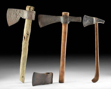
Sold202118th C. American Iron & Wood Axes & Axe Head (4)North America, United States, ca. 18th to 19th century CE. A collection of 4 iron axe heads, three with their wooden handles intact. The one without a handle is stamped with maker marks for the CollinSee Sold Price
3 days LeftEast-Wing Estate Sales & Auction CompanyLate 18th C. Dutch Serpentine Chest of Drawers$160(2 bids)
4 days LeftArtelisted18th C. Geographie Moderene Historique et Politique: Les Isles de Sardaigne et de Corse$150
4 days LeftArtelisted18th C. Geographie Moderene Historique et Politique: Le Danemark Divisé par Provinces et Diocèses$150
Oct 14Burns Auction & Appraisal LLCCountry Scene with Figures, oil on canvas, Dutch early 18th c.$200(2 bids)
Oct 14Burns Auction & Appraisal LLCVillagers with Chateau, oil on canvas, Dutch early 18th c.$140(3 bids)