Sold2022(2) 18th c. road maps, London-Norwich, etc.Two hand colored maps of roads from London to Norwich, England, and from Shrewsbury to Holywell, England. A printed description in an attached envelope on the back of one states that they were made bySee Sold Price
Sold2017Two(2) 19thC. English AquatintsTwo(2) hand colored aquatints. May - View of St. Petersburgh, Russia. October - View of Kassan. British Regency Period Aquatints after Mornay. Well frame. Provenance: W. Graham Arader III, NY; 12in. XSee Sold Price
Sold2022Two early hand colored European views/maps.Two early hand colored European views/maps including:1)A historical view of the German town of Schleswig by Georg Braun and Frans Hogenberg (between 1572 and 1618) on laid paper - Crease down the middSee Sold Price
Sold2024Two Maps of the United States by William Faden (London, 1785 and 1796)Two Maps of the United States by William Faden (London, 1785 and 1796) Two hand-colored maps engraved by William Faden (British, 1749-1836), London, 1785 and 1796. Titled "The United States of North ASee Sold Price
Sold2023Two Prints, Washington, Bermuda"Washington's First Interview With Mrs. Cutis", after a painting by John Whetten Ehninger, and a 19th century hand colored view of St. George Bermuda, both prints in deep walnut frames. Dimensions:TheSee Sold Price
Sold2021TWO FRAMED PRINTS.Nineteenth century. One is "Napoleon Wounded in Front of Regensburg." 11"h. 12.5"w. And a hand-colored map of St. Helena and the Bay Agoa de Saldanha. 12.5"h. 9.75"w.See Sold Price
Sold2016Two Hand-Colored Engravings of LondonTwo antique hand-colored engravings of London published by Laurie & Whittle, circa 1794. Comprises: 1.) "A View of London and Westminster. 2.) "A View of Royal Palace of Windsor". [Sight (both): 10 1/See Sold Price
Sold2020TWO PHOTOGRAPHIC PRINTS, VIEWS OF LONDON BY GARRYTwo hand-colored images of London by Garry Seidel. Paliament and Westminster Bridge; Tower Bridge. Artist: Garry Seidel Issued: 20th c. Dimensions: 11"L x 14"W Provenance: David Farin CollectionSee Sold Price
Sold2020F. B. Werner, "Roma" hand-colored map, 1730F. B. Werner, "Roma" hand-colored map, 1730, Panoramic view of Rome, hand-colored engraving on laid paper, no watermark observed, two sheets joined at center, marked "F. B. Werner delin Ao 1730" and "See Sold Price
Sold2022Harris (Pub) 1820 Hand Col World Hemisphere Map"The Two Hemispheres" Hand Colored Copper Engraved Map Published 1820 by J. Harris & Son., London for "The Traveller; Or, An Entertaining Journey Round the Habitable Globe" Paper Size: 6 x 4 inch (16See Sold Price
Sold2021A GROUP OF TWO 18TH CENTURY MAPS OF THE AMERICAS,A GROUP OF TWO 18TH CENTURY MAPS OF THE AMERICAS, LONDON AND PARIS, 1736-1780, two hand-colored engravings on paper, comprising, "FLORIDA Called by ye French LOUISIANA," after works by Herman Moll (16See Sold Price
Sold2023John Ogilby, Three Engraved Road Maps on laid paperJOHN OGILBY (Scottish, 1600-1676), Three Double Paged Hand Colored Engraved Road Maps on laid paper, including "The Road from London to St. Davids in Com. Pembroke," "The Road from London to St. NeottSee Sold Price
Sold2018Raoul Varin (French, 1865-1943) Two Hand-ColoredRaoul Varin (French, 1865-1943) Two Hand-Colored Aquatints. 'Michigan Avenue Looking North' and 'View of Wells and Clark St. Bridges', both dated to 1929, each pencil signed lower right, the first insSee Sold Price
Sold2023Cary's New Map of London & its Vicinity, 1840Cary's New Map of London and its Vicinity, hand-colored engraving, inscribed "Cary's New Map of London and its Vicinity / Showing the limits of the two penny post-delivery / Published by the AuthoritySee Sold Price
Sold2021(5) 17TH C. EUROPEAN VIEWS HAND-COLORED ENGRAVINGSHand-colored engravings including Vienna 1785, two of London including view of Westminster Bridge with windows cut out and backed for light show, large Italian view. Dimensions: (Largest mat) H 19" xSee Sold Price
Sold2023TWO JOHN BULL ENGLISH POLITICAL CARTOONS 1798 1806Two English political hand colored satirical cartoons. 'John Bull, the Idol of all Nations' London Pub. by w. Holland (??) Oxford St. December 1798. Measures: 12" T x 14.25". Margins cut, two upper coSee Sold Price
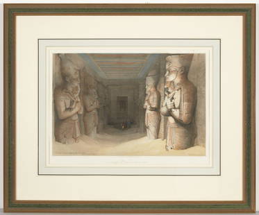
Sold2020Two Rare Prints of Egypt David Roberts, RATwo rare hand colored prints by David Roberts, R. F Haghe Lith. Published by F.G Moon. 20 Threadneedle St. March 1st 1847 and August 1st 1846. The first "View under the Portico of Temple of Edflou-UppSee Sold Price
Sold2024The Pass of Atbara in Abyssinia (Plate XIX) by Henry SaltLondon, published by William Miller, 1809. Drawn by Henry Salt. Engraved by D. Havell. From "Twenty-four views in St. Helena. Aquatint and hand-colored.See Sold Price
Sold2019W. Havell Aquatints Engraved by R. Havell [Rivers]Two William Havell hand-colored aquatints engraved by R. Havell. Titles 'Windsor Castle' and 'View of Taplow, from Maidenhead Bridge' printed below image, center. 'London, Published August 1, 1818, bySee Sold Price
Sold2023John Senex, "The Kingdom of China"Hand colored 18th century map "newly augmented" by British cartographer John Senex (1678 - 1740). Originally sold by London merchants Thomas Bassett in Fleet Street and Richard Chiswell in St. Paul'sSee Sold Price
WARD, FRANCIS SWAIN. A View of Part of St. Thomè Street, Fort St. George. (A Brief History ...WARD, FRANCIS SWAIN. A View of Part of St. Thomè Street, Fort St. George. (A Brief History of Ancient and Modern India. #13.) , Hand-colored aquatint. 11 7/8 x 16 3/4 in. Framed. London, June 4,See Sold Price
Sold2023Brown & Philip C1850 Lot of 4 Holy Land Views. Jerusalem etcIcnl Jerusalem, Holy Sepulchre, Nazareth and Tower of Babel. One black and white, one Hand Colored, and two Color Printed Steel Engraving Published C1850, London for "The Holy Bible..." J. Brown and HSee Sold Price
Sold2022London.- Ogilby (John) The Continuation of the Road from London to Bristol; The Road from London toNO RESERVE London.- Ogilby (John) The Continuation of the Road from London to Bristol; The Road from London to St Davids, two road-strip maps, engravings with full hand-colouring, each approx. 340 x 4See Sold Price
Sold2021N. Currier, (4) hand-colored lithographs, 1849-52N. Currier, (4) hand-colored lithographs, 1849-52, Nathaniel Currier (American, 1813-1888), "The High Bridge at Harlem, N.Y.", two views, with the 152 Nassau St. address, 9"h x 12.75"w (sight) and 9.5See Sold Price
5 days LeftTrillium Antique Prints & Rare BooksDavid Roberts, RSE - Slave Boat on the Nile, View Looking Towards the Pyramids of Dashour and$500
5 days LeftTrillium Antique Prints & Rare BooksEdwards - Map of England & Europe with Beetles & Birds$50
5 days LeftTrillium Antique Prints & Rare BooksEdwards - Pair of Duck Engravings (Summer Duck, Chinese Teal)$50
Jun 25Freeman's | Hindman[Travel & Exploration] Bowdich, T. Edward: Mission from Cape Coast Castle to Ashantee...$250
BonhamsWELD'S TRAVELS.... WELD, ISAAC, JR. 1774-1856. Travels Through the States of North America, and ...$10
5 days LeftTrillium Antique Prints & Rare BooksDavid Roberts, RSE - Jerusalem from the South$500(1 bid)
Jul 11Eldred'sTWO HAND-COLORED ENGRAVINGS BY ELEAZAR ALBIN Late 18th Century On cream laid paper, 10.5" x 8"$100
Jul 11Eldred'sTWO HAND-COLORED BOTANICAL ENGRAVINGS 1805 Both 10.25" x 7.75" sight. Framed 18" x 15.25".$70


![W. Havell Aquatints Engraved by R. Havell [Rivers]: Two William Havell hand-colored aquatints engraved by R. Havell. Titles 'Windsor Castle' and 'View of Taplow, from Maidenhead Bridge' printed below image, center. 'London, Published August 1, 1818, by](https://p1.liveauctioneers.com/5755/147592/74586211_2_x.jpg?height=310&quality=70&version=1565302309)


![[Native-Americana] Bodmer, Karl: Cave-In-Rock. view on the Ohio (1 of 1)](https://p1.liveauctioneers.com/65/332523/179335179_1_x.jpg?height=282&quality=70&version=1717622830)


![[Maps & Atlases] Speed, John: Spaine (1 of 2)](https://p1.liveauctioneers.com/65/332523/179335175_1_x.jpg?height=282&quality=70&version=1717709446)
![[Travel & Exploration] Bowdich, T. Edward: Mission from Cape Coast Castle to Ashantee... (1 of 3)](https://p1.liveauctioneers.com/65/332523/179335283_1_x.jpg?height=282&quality=70&version=1717709446)


