Sold2021[Mining Interest, Antimony, Coal, Granite]Lot of 3 publications from the U.S. Department of the Interior, all printed between 1911 and 1919 in Washington D.C. All 8vo in original wrappers, all with folding maps.See Sold Price
Sold2022Prospectus of Fairmont Gold Mining Co. [154523]4 page 1895 prospectus of The Fairmont Gold Mining Company. Nice mine map on front page. Red editing on pages 1-3. Mine property at Independence (near Cripple Creek, now a ghost town).Date: Country (iSee Sold Price
Sold2022Antique United States MapsMeasures 28.5"h x 14.5"w. Neat piece of 3 different maps US, North America & Mexico. In good condition, see pictures.See Sold Price
Sold2019United StatesReserve Reduced! Title: United States Publication Date: 1805 Cartographer: ARROWSMITH/ENGRAVED BY E. JONES Publisher: LONGMAN, HURST, REES & ORME Size (inches): H10 - W12.3 Map showing U.S. to Miss. RSee Sold Price
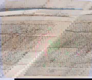
Sold2023WWII U.S. MILITARY WAR MAPS OF FRANCE - (3)171283 WWII U.S. MILITARY WAR MAPS OF FRANCE - (3) WWII U.S. military war maps of France to include, one sheet 6F/6 Vire France(50000) war map second edition, one sheet 6E/6 Isigny France(50000) war mSee Sold Price
Sold2022(3) PICTORIAL MAPS OF US, CONN VALLEY & BOSTON1930s 22 x 30 approx (and smaller) Condition: Good to fairSee Sold Price
Sold2023Map of the United States and TerritoriesPublication Date: 1871 Title: Map of the United States and Territories Cartographer: H.F. Walling & O.W. Gray Publisher: H.F. Walling & O.W. Gray Height: 16.5 Width: 25.3 Detailed map showing U.S. asSee Sold Price
Sold2018Map of Mexico, Central America, and the West Indies.Title/Content of Map: Map of Mexico, Central America, and the West Indies. Date Printed: 1884 ca. Cartographer: MITCHELL, SAMUEL AUGUSTUS (JR.) Size: 13.3X21.3 Map showing lower U.S., Mexico, West IndSee Sold Price
Sold2023U.S. MILITARY FIELD MAPS OF FRANCE 1939-1945 -(3)170302 U.S. MILITARY FIELD MAPS OF FRANCE 1939-1945 -(3) U.S. military field maps of France 1939-1945 to include one France and Belgium (50000) Sittard Field Map Second Edition Sheet 48, One France (5See Sold Price
2018U.S GOVERNMENT SURVEY COPPER MAP PLATES, SET OF 3Park Ridge, NJ-NY US Government Copper Map Engravings for Park Ridge, NJ-NY, scale 1:31,680 surveyed 1934-1944. The Original Master Set engraved on 3 plates measures approximately 21 in. H x 17 in. W.See Sold Price
Sold2015CHINESE CARVED ROSEWOOD COFFEE TABLECHINESE CARVED ROSEWOOD COFFEE TABLE: Shaped skirt with carved dragon motifs, lower stretcher, shaped feet. Overall 18" h. x 43 1/2" x 21 3/4". Former property of a US Foreign Service Officer living iSee Sold Price
Sold201510 Maps: New York street grid, views, US, MD[New York/Maryland/US] 10 Maps. 8 1/8 x 9 3/4 in. to 17 7/8 x 27 1/2 in. Sold with all faults. ++ MAP OF THE CITY OF NEW-YORK 1852. Folding map from an annual edition of Valentine’s Manual. ++ PARTSee Sold Price
Sold2017McNally: Map of the United States, 1887Map: 1887 Rand McNally US Map -- Map of the United States Cartographer: Rand McNally Year/Place: 1887, Chicago Dimensions: 14.5 x 27.3 in. A very nice US map, showing great deal of topographical and sSee Sold Price
Sold2020Rare map of Eureka Mining District, NevadaHeading: (Nevada) Author: Hall, Leon M. Title: Compiled Map Showing Properties of the Eureka Mining District, Eureka County, Nevada Place Published: Eureka County, Nevada Publisher: Date PublisheSee Sold Price
Sold20191872 Warner Beers Map of Southern US -- Map of theReserve Reduced! Title/Content of Map: 1872 Warner Beers Map of Southern US -- Map of the Southern States Date: 1872, Chicago Cartographer: Warner Beers Size: 16.7 x 27.3 in. This is a nice large doubSee Sold Price
Sold2022Vintage Wood Puzzle of U.S. Map & CapitalsVintage Wood Puzzle of U.S. Map & Capitals, measures 18 1/2 x 12 3/4 inches. Vintage, vintage wood puzzle, vintage toys, vintage toy map, wooden puzzle, 5See Sold Price
Sold2021(3) MAPS: UNITED STATES, MARTHA'S VINEYARD, EUROPE(lot of 3) Framed maps, including: (1) Martha's Vineyard, U.S. Geological Survey, sight: 10.25"h, 14.25"w, overall: 12"h, 16"w, (1) Hungarian map of Europe, sight: 8.25"h, 10"w, overall: 13.25"h, 15"wSee Sold Price
Sold2024US Gold Type Set Unc.US Gold Type Set Unc. Including: 1891-S $20, 1924 $20, 1893 $10, 1910 $10, 1901-S $5, 1909-D $5, 1874 $3, 1901 $2 1/2, 1926 $2 1/2, 1853 $1 Type 1, 1855 $1 Type 2, and 1856 $1 Type 3 Property from: anSee Sold Price
Sold2024US Gold Type Set Unc.US Gold Type Set Unc. Including: 1897 $20, 1925 $20, 1901 $10, 1932 $10, 1881-S $5, 1909 $5, 1874 $3, 1907 $2 1/2, 1911 $2 1/2, 1851 $1 Type 1, 1854 $1 Type 2, and 1856 $1 Type 3 Property from: an EstSee Sold Price
Sold2022Three Antique Hawaiian Maps, US Government3 1920s Hawaiian Maps. Island Of Oahu Map Approximately 47.1875 x 36.5 in. Hawaiian Islands Approximately 45.875 x 35.125 in. Hawaii To Oahu Approximately 46.4375 x 35.5625 in.See Sold Price
Sold2022Mining Books, 3, with 2 from Ott Heizer [154452]US Dept. of Interior Level Book DI-3 stamped on flypage Ott F Heizer, 1956-57. Examination of Prospects by Gunther, embossed Ott F Heizer on front cover. California Mines and Minerals, 1899 Souvenir ESee Sold Price
Sold2016Set of 3 U.S. Geological Survey Copper Map PlatesRare Set of Three United States Geological Survey (USGS) Copper Map Plates, each of the three engraved plates illustrating a topographical map of Madison Parish, Louisiana, including its plantations aSee Sold Price
Sold2018Radefeld: U.S. Geological MapMap: Geognostische Karte der Nord-Americanische Freistaaten Cartographer: Bibliographischen Instituts. / Radefeld Place/Date: Hildburghausen / 1849/1857 Size: 14 3/4" x 12" Condition: original outlineSee Sold Price
Sold20221900 US Government Map of Improved Lands -- ProportionTitle: 1900 US Government Map of Improved Lands -- Proportion of Improved Land to Total Area at the twelft Census 1900 Cartographer: US Department of the Interior Year/Place: 1900 Dimensions: 8.3 X 12See Sold Price
1818 AuctioneersLiterature. First Editions. Galsworthy, John - A Man of Devon. Edinburgh: William Blackwood and£60
Jun 07Freeman's | Hindman[MAPS]. ORTELIUS, Abraham. A group of 3 engraved maps with hand-coloring.$150(1 bid)
May 29Julien's AuctionsThe Rolling Stones | Bill Wyman 1978 U.S. Tour Poster Limited-Edition Print$150
May 31Freeman's | Hindman[CIVIL WAR]. RUSSELL, Andrew Joseph (1830-1902), photographer. Bridge No. 2, U.S. Military Railroad$750
May 31Freeman's | Hindman[CIVIL WAR]. Photographer unknown. U.S. Gunboat "Mendota" and other Ships on James River, Virginia.$250
4 days LeftLeonard Auction, a division of The Leonard Company1c and 5c Coin Book Assortment$150(1 bid)
4 days LeftLeonard Auction, a division of The Leonard CompanyMiscellaneous Coin Assortment$750(6 bids)
4 days LeftLeonard Auction, a division of The Leonard CompanyHenri Gabriel Ibels (French, 1867-1936) Lithograph Assortment$200


![[Mining Interest, Antimony, Coal, Granite]: Lot of 3 publications from the U.S. Department of the Interior, all printed between 1911 and 1919 in Washington D.C. All 8vo in original wrappers, all with folding maps.](https://p1.liveauctioneers.com/3532/215986/110647640_1_x.jpg?height=310&quality=70&version=1629830116)
![U.S. Mining CoÃs Property Maps (3) [137611] First Image](https://p1.liveauctioneers.com/2699/211841/108079405_1_x.jpg?height=300&quality=1&version=1626732246&width=300)
![U.S. Mining CoÃs Property Maps (3) [137611] First Image](https://p1.liveauctioneers.com/2699/211841/108079405_1_x.jpg?height=300&quality=95&version=1626732246&width=300)
![Prospectus of Fairmont Gold Mining Co. [154523]: 4 page 1895 prospectus of The Fairmont Gold Mining Company. Nice mine map on front page. Red editing on pages 1-3. Mine property at Independence (near Cripple Creek, now a ghost town).Date: Country (i](https://p1.liveauctioneers.com/2699/258191/134290988_1_x.jpg?height=310&quality=70&version=1660351799)


![10 Maps: New York street grid, views, US, MD: [New York/Maryland/US] 10 Maps. 8 1/8 x 9 3/4 in. to 17 7/8 x 27 1/2 in. Sold with all faults. ++ MAP OF THE CITY OF NEW-YORK 1852. Folding map from an annual edition of Valentine’s Manual. ++ PART](https://p1.liveauctioneers.com/179/82189/42599761_1_x.jpg?height=310&quality=70&version=1447864785)


![Mining Books, 3, with 2 from Ott Heizer [154452]: US Dept. of Interior Level Book DI-3 stamped on flypage Ott F Heizer, 1956-57. Examination of Prospects by Gunther, embossed Ott F Heizer on front cover. California Mines and Minerals, 1899 Souvenir E](https://p1.liveauctioneers.com/2699/258191/134291034_1_x.jpg?height=310&quality=70&version=1660351799)


![[MAPS]. ORTELIUS, Abraham. A group of 3 engraved maps with hand-coloring. (1 of 4)](https://p1.liveauctioneers.com/197/329395/177650539_1_x.jpg?height=282&quality=70&version=1715364962)


![[CIVIL WAR]. RUSSELL, Andrew Joseph (1830-1902), photographer. Bridge No. 2, U.S. Military Railroad (1 of 2)](https://p1.liveauctioneers.com/197/329785/177758322_1_x.jpg?height=282&quality=70&version=1715625218)
![[CIVIL WAR]. Photographer unknown. U.S. Gunboat "Mendota" and other Ships on James River, Virginia. (1 of 2)](https://p1.liveauctioneers.com/197/329785/177758330_1_x.jpg?height=282&quality=70&version=1715625218)


