Sold2022Rare J.H. Colton Map, Southern Regions, Antarctica, South PoleRare mid 19th Century map of Southern Regions, Antarctica, South Pole, The Southern Polar Regions by J. H. Colton, from an 1855 first edition, Colton's Atlas of The World. A rare look at Antarctic expSee Sold Price
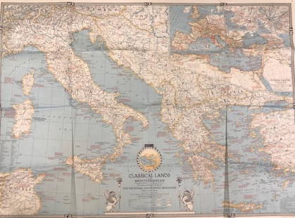
Sold2020Vintage National Geographic MagazineDescription: Vintage paper map from National Geographic Magazine, depicting the classical lands of the Mediterranean. Copyright 1940. Material: paper. Measurement: approximate 26.5"h x 34"w (INCHES).See Sold Price
Sold2019Vintage National Geographic Magazine's Map of Mexico,Description: Vintage paper map from National Geographic Magazine, depicting Mexico, Central America & the West Indies. Copyright 1939. Material: paper. Measurement: approximate 33"h x 40"w (INCHES). SSee Sold Price
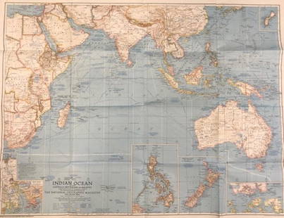
Sold2020Vintage National Geographic Magazine map of the IndianDescription: Vintage color paper map from National Geographic Magazine depicting the Indian Ocean. Copyright 1941. Material: paper. Measurement: approximate 26.5"h x 34"w (INCHES). Shipping cost: $12;See Sold Price
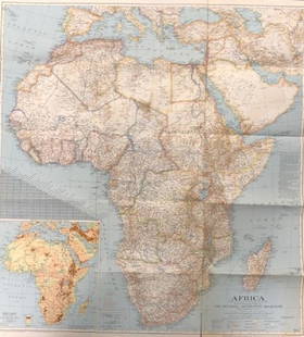
Sold2020Vintage National Geographic Map of AfricaDescription: Vintage color paper map from National Geographic Magazine depicts Africa. Some tearing on bottom. Map is copyrighted from 1943. Material: paper. Measurement: approximate 26.5"h x 34"w (INSee Sold Price
Sold2017Collection of 35 vintage mapsCollection of 35 vintage maps mostly from The National Geographic Magazine including Northern Africa; The Philippines; The Top of the World; Scandinavia; Northern Europe; Southwestern United States; JSee Sold Price
Sold2020(44)Vintage National Geographic Maps - Asst Regions(44)Vintage National Geographic Maps - Asst RegionsSee Sold Price
Sold2019ASSEMBLED LOT OF VINTAGE MAPSASSEMBLED LOT OF VINTAGE MAPS: Maps of the east coast, National Geographic maps, AAA road maps, 6 1/4" X 10 1/2" $40 - $80 Shipping:See Sold Price
Sold2021Uncommon version of Colton Southern Regions mapRarely seen variant state of Colton's map of the South Pole, Antarctica, or the Southern Polar Regions. Shows the great southern continent with both solid and tentatively sketched in borders. Notes thSee Sold Price
Sold20231st edition map of the South Pole, or Antarctica by ColtonExcellent 1855 first edition example of J. H. Colton’s map of the South Pole, Antarctica or Southern Polar Regions. The map gives an excellent overview of the state of Antarctic exploration andSee Sold Price
Sold2022Vintage Map Print - Map of the World - Africa - Europe - Australia - 1972Title: Vintage Map Print - Map of the World - Africa - Europe - Australia - 1972 Description: A wonderful lithographic map from a magazine National Geographic. National Geographic has been publishingSee Sold Price
Sold2022Vintage Map Print - Europe -The Historic Mediterranean - Italy - Greece - 1982Title: Vintage Map Print - Europe -The Historic Mediterranean - Italy - Greece - 1982 Description: A wonderful lithographic map from a magazine National Geographic. National Geographic has been publisSee Sold Price
Sold2018Vintage Maps110+ Assorted California Maps; 50+ Assorted USA and World Maps; 25+ national Geographic Magazine Maps; 1950s -60s Classic Artistic. Road Maps of the Western States; 7Union Oil; Chevron Oil; Shell Oil;See Sold Price
Sold2022Vintage Discovery, Map, EphemeraThis lot consists of 1 postcard autographed by George Wallace, 4 invitation letters to the Space Shuttle Columbia liftoff in 1986, 1 $2 bill, various National Geographic maps (approx 30) and 3 AfricanSee Sold Price
Sold2024Large Group of Vintage Magazines and MapsLarge Group of Vintage Magazines and MapsIncluding, Popular Mechanics, Army Talks, Flying Aces, Battle Maps, Popular Science, and maps from National Geographic Magazine.See Sold Price
Sold2024Beverly Joubert b.1957 Elephant Chromogenic PhotoBeverly Joubert (South African, Born 1957). A limited edition chromogenic photograph, mounted on acrylic. In collaboration with National Geographic, titled "Textures of Life". A black and white photoSee Sold Price
Sold2021Vtg Maine Acadia National Park & Vacinity Original MapVintage Maine Acadia National Park & Vacinity Original Map (35" x 37") & NOT A COPY! Preowned from an Estate. FREE SHIPPING!See Sold Price
Sold2020Gross, Alexander 1920 Large Maps. North & South PolePair of Large Lithograph Maps Published 1920, London for "The Daily Telegraph Victory Atlas of the World" by Alexander Gross. Centre fold as published. Paper Size: 25 x 19.5 inch (64 x 49cm) Good CondSee Sold Price
Sold2019Bartholomew, John 1922 Map of the South PoleLarge Lithograph Map Published 1922 by The Times, London for "The Times Survey Atlas of the World" Maps by John George Bartholomew of the Edinburgh Geographical Institute. Centre fold as issued. PaperSee Sold Price
Sold2020Stieler, Adolph 1905 Pair of Maps of North & South Pole"Nord-Polar Karte" and "Sud-Polar Karte" Lithograph Maps Published 1905 by Justus Perthes, Gotha for "Stielers Hand-Atlas" by Adolf Stieler. Centre fold as published. Paper Size: 18.5 x 15.5 inch (48See Sold Price
Sold2019Bartholomew, John 1922 North & South Pole, 2 MapsLarge Lithograph Maps Published 1922 by The Times, London for "The Times Survey Atlas of the World" Maps by John George Bartholomew of the Edinburgh Geographical Institute. Centre fold as issued. PapeSee Sold Price
Sold2024Kohler & Weigel - Map of the World with North and South Pole viewsThis originally hand-colored engraving is from Johnn David Kohler's Schul- und Reisen-Atlas aller zu Erlernung der alten, mittlern und neuen Geographie dienlichen Universal- und Particular-Charten...See Sold Price
Sold2017Antarctic South Pole Drift Ice Limit 1886 MapAntarctic. South Pole. Drift Ice Limit. Wilkes Graham Victoria Land, 1886 Map. Title/content of Map: 'south Polar Chart' date Printed: 1886 image Size: Approx 15.0 X 21.0cm, 6 X 8.25 Inches (medium) tSee Sold Price
Sold2018The South Pole. An Account of the Norwegian AntarcticThe South Pole. An Account of the Norwegian Antarctic Expedition in the "Fram," 1910-1912. With maps and numerous illustrations. 2 volumes. Frontispiee, xxxv, 392p, illustrations, map; frontispiece, xSee Sold Price
BonhamsADMIRAL BYRD'S DIARY FROM BOLLING ADVANCE BASE, WINTER 1934. BYRD, RICHARD EVELYN. 1888-1957. Au...$30,000
2 days LeftPotter & Potter AuctionsCRISANTI, Mark (American, b. 1964) National Geographic # 4....$300
5 days LeftChina Luban Art & Antique, Inc.Vintage Gavara Silver Bracelets by Kamsali Silversmiths$10(1 bid)
7 days LeftBrandywine Valley AuctionsVintage American School California Artist Ethel Hagen African American Mother and Child SIgned$50(1 bid)
3 days LeftRail & Road Auctions45 Peices of Western Railroad Paper Ephemera - Southern Pacific, Northern Pacific, Union Pacific,$30(1 bid)
3 days LeftJulien's AuctionsDuke of Kent | 1900 Commemorative Linen Scarf With South Africa Map And Poem$50