Sold2017America, Rare Early Map of the Americas"America", Rare Early Map of the Americas by Jodocus Hondius (Flemish/Dutch, 1563-1612) for a French edition of Mercator's Atlas, North and South America, hand-colored copper engraved map, published ASee Sold Price
Sold2020Antigua labeled Antego. RARE early map.Title: Antigua labeled Antego. RARE early map. Description: c1732/1736 from the Atlas Minor by Herman Moll, London. VERY IMPORTANT early map of the island. Showing all the settlements and plantations.See Sold Price
Sold20211640 Jansson Map of Rhine River Area in Netherlands andTitle: 1640 Jansson Map of Rhine River Area in Netherlands and Germany in Part -- Descriptio Fluminum Rheni, Vahalis et Mosae Cartographer: J Jansson Year / Place: c 1640, Amsterdam Map Dimension (in.See Sold Price
Sold2023Rare Early 1900's Map of Porto Rico ( Puerto Rico )Rare early 1900's ( copyright of 1908 ) Map of Porto Rico, including Port San Juan, Islands West of Porto Rico, Mayaguez Bay & Port Ponce from Rand, McNally & Co. 8 3/4" X 12". ** fold through the cenSee Sold Price
Sold2023Japanese Map of Ancient China, Apparently 12th - 16th CenturyAn exceptional and rare early Japanese map, hand painted, depicting China from the Zhou or Qin Dynasty. The map depicts the Chinese Nine Zhou, or provinces, utilizing nomenclature used in Japan circaSee Sold Price
Sold2022American Quilted Cove Gilt FrameAmerican, ca. 1850, a very rare early Hudson River School or still life frame with Orientalist top edge fitted with later mirror plate. Labels verso for A. C. & J. Hewlett and Gill & Lagodich. 34" x 3See Sold Price
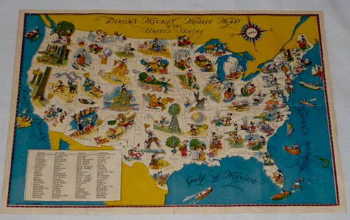
Sold2022Walt Disney Dixon's Mickey Mouse Map of United StatesEarly Disneyana collectible map. Copyright Walt Disney Enterprises 1935. Rare early pictorial map of the United States , richly illustrated with Disney character vignettes in each of the 48 states, MiSee Sold Price
Sold2023American Quilted Cove Gilt Frame 14" x 22"American, ca. 1850, a very rare early Hudson River School frame having naturalistic top edge. Overall 22" x 30", Rabbet 14" x 22", Molding 4 1/4".See Sold Price
Sold20191919 Rhine River Birds Eye View for Occupying US ForcesTitle/Content of Map: 1919 Rhine River Birds Eye View for Occupying US Forces -- Rhine Panorama for the Men of the American Army of OccupationÂ… Date: 1919 Cartographer: YMCA sponsored Size: 62.6 XSee Sold Price
Sold2020RARE 1596 map of Rhine Palatinate regionTitle: RARE 1596 map of Rhine Palatinate region Date/Period: 1596 Materials: Copperplate engraved Size: 14" x 10 1/4" Description: This is a rarer variation of Quads map of the region. The portrait isSee Sold Price
Sold2017Antique Important Map of Texas, 1843Title/Content of Map: Texas. Rare and important early Map. Date Printed: 1843 Cartographer: based on the work of H.C. Tanner Material/Medium: Paper Size: 17" x 14" Hand colored engraved Map. From theSee Sold Price
Sold2023Japanese Map of Feudal Castles Apparently Circa 1550A rare and early Japanese map, depicting the feudal castles of Owari province, including Kiyosu Castle, occupied by Shiba Yoshimune as governor of Owari and head of the Shiba Clan. Apparently of the pSee Sold Price
Sold2021Astoria (Columbia River)Astoria (Columbia River) Early Rare View Artist: Alfred Agate Print Type: Engraving Date: 1845 Dimensions: 5 x 7 1/2" Subject:See Sold Price
Sold2022Antique American Modernist Rushing River Rapids Rare Early Oil PaintingAntique American school oil painting. Oil on canvas. Framed. Unsigned. Image size, 7 by 11.See Sold Price
Sold2022Early HUDSON RIVER MAP, softcover, by BRYANT UNION PUBLISHING CO. NEW YORK CITY. Measures approx.Early HUDSON RIVER MAP, softcover, by BRYANT UNION PUBLISHING CO. NEW YORK CITY. Measures approx. 104" long, on back side is prominent places & advertising. Nice overall condition for its fragility. ISee Sold Price
Sold2022Rare Rev. War map of Hudson River campaign, pre-Vermont, 1832Rare Revolutionary War battle map of the important Hudson River corridor showing northern New England and Quebec. This map is from the rare atlas from John Marshall’s “Life of Washington” publisSee Sold Price
Sold2022Tombleson, William 1834 Map of the River Rhine"Tombleson's Upper Rhine" Showing Germany and Switzerland. Steel Engraved Map Published 1832-34, London for "Tombleson's Upper Rhine" Edited by William Gray Fearnside. Illustrated by William TomblesonSee Sold Price
Sold2023Mary Ann Carroll 24x36 'St. Lucie River Sunset' In the BookMary Ann Carroll (1940-2019) Florida Highwaymen, Florida Art Hall of Fame Artist. Rare, early oil painting 'St. Lucie River Sunset' on Upson board, featured in Gary Monroe's book "Mary Ann Carroll : FSee Sold Price
Sold2023Rare map of Upper Territories by Mathew Carey, 1814Early and rare map of the old Northwest Territory. In this map the area of Michigan has yet to be understood. The extents of Saginaw Bay and Green Bay are also more or less guessed at. The map reflectSee Sold Price
Sold2016JOHN MELISH (SCOTLAND/AMERICAN 1771-1822), EARLY ANDJOHN MELISH (SCOTLAND/AMERICAN 1771-1822), EARLY AND RARE MAP OF THE UNITED STATES OF AMERICA, C.1813. ENTERED AS THE ACT DIRECTS AND PUBLISHED BY JOHN MELISH, PHILADELPHIA, JUNE 1813. SIGHT 13 X 17 1See Sold Price
Sold20181824 RARE & Early American Holy BIBLE New York Daniel S1824 RARE & Early American Holy BIBLE New York Daniel Smith Stereotype ed MAP A large, rare early 19th-century family Bible with Daniel Smith’s stereotype edition. This impressive tome features an iSee Sold Price
Sold2021Early Map of Greece and EnvironsEarly and Rare map by Jean Covens and Corneille Mortier of Greece, the Aegean, Asia Minor and the lower Balkans. 19 ½ x 26 inches (approximately)See Sold Price
Sold2015Kingdom of IrelandJohn Speed (1552-1629). Engraved map. London: 1610 (1676). 17 1/4 x 22 inches. A rare, early printing of John Speed’s renowned map of Ireland. The map is decorated with a panel of costume figures deSee Sold Price
Sold2023Map of the American Colonies from December, 1754This map is titled 'An Accurate Map of the English Colonies in North America bordering on the River Ohio', a scarce early map of the British Colonies in North America and one of the earliest maps to aSee Sold Price
May 16Potter & Potter AuctionsMap to Acquaint You with the Great Mission Bay Project. 194...$125(1 bid)
304 Lots AwayGreat Estates Auctioneers & AppraisersJOHANN BAPTIST HOMANN 1700'S SCANDINAVIA MAPSee Sold Price
6 days LeftTrillium Antique Prints & Rare BooksPtolemy & Magini, pub. 1620 - Map of the Americas$50(1 bid)
6 days LeftTrillium Antique Prints & Rare BooksPtolemy & Magini, pub. 1620 - Map of the World$50(1 bid)
6 days LeftTrillium Antique Prints & Rare BooksPtolemy & Magini, pub. 1620 - Map of the Ancient World with Africa, Europe, Asia$50
6 days LeftTrillium Antique Prints & Rare BooksPtolemy & Magini, pub. 1620 - Map of Taprobana, Island in Sumatra$50
May 09Hunt and Peck Estate Services, Inc.John Cary Map Of The Principal Roman Camps, Forts, Walls & C. England/Scotland$50
Featured2 days LeftJasper521795 Lewis Map of Maryland -- The State of Maryland, from the best Authorities$360
May 15University ArchivesDeclaration of Independence, Very Early British Publ. in Gentleman's Magazine & Rare Map$1,000
May 15University ArchivesFeb. 1777 Issue of The Gentleman's Magazine with Superb Map of Philadelphia$140(1 bid)
May 12Schilb Antiquarian Rare Books1977 JRR Tolkien 1st ed 1st Printing Silmarillion Lord of the Rings + MAP + DJ$200(5 bids)