Sold2018Miller Map of the US with Presidential PortraitsMiller, William (19th Century). Map of the United States (with 13 presidential portraits + Capitol in Washington (unfinished). Engraved map. Ohio: William & Thomas Miller, 1852. 23 ½" x 31" sheet.See Sold Price
Sold2017Revolutionary War Map of the Battle of SaratogaAmerican Revolution 1780 Revolutionary War Map Engraved by William Faden 1780-Dated Revolutionary War, Hand-Colored Map entitled, “Plan of the Encampment and Position of the Army Under His Excelly.See Sold Price
Sold20201610 H/C Engraved Map of Worcestershire, SaxtonBeautiful 1610 Hand-colored Copperplate Engraving of Map of Worcestershire by Cartographer Christopher Saxton Entitled Wigorniensis Comitatus Sabrinae | Engraved map by William Hole | From Camden's BrSee Sold Price
Sold2024Two Maps of the United States by William Faden (London, 1785 and 1796)Two Maps of the United States by William Faden (London, 1785 and 1796) Two hand-colored maps engraved by William Faden (British, 1749-1836), London, 1785 and 1796. Titled "The United States of North ASee Sold Price
Sold2017First printed plan of New Haven, showing Yale CollegeA plan of the town of New Haven : with all the buildings in 1748...William Lyon (fl. c. 1800-1806). Engraved map. New Haven: T. Kensett, 1806. 28 1/4 x 20 1/2 inches sheet. The Kensett map is the firsSee Sold Price
Sold2021Scarce c1610 map of Scotland, Wm. HoleFirst map of Scotland made by an Englishman in England. Fine map of Scotland engraved by William Hole (one of the earliest English engravers) for the first illustrated edition of Camden’s Britannia,See Sold Price
Sold2021Lochhead (Pub) 1811 Rare Map. AfricaCopper Engraved Map Published 1811 by William Lochhead, Berwick for "Modern Geography: And a Compendious General Gazetteer" Rare. Folds as issued. Paper Size: 12 x 10 inch (30 x 26cm) Very minor toninSee Sold Price
Sold2021Lochhead (Pub) 1811 Rare Map. World HemisphereCopper Engraved Map Published 1811 by William Lochhead, Berwick for "Modern Geography: And a Compendious General Gazetteer" Rare. Folds as issued. Paper Size: 17 x 11 inch (43 x 28cm) Some creasing. VSee Sold Price
Sold2023South America. Bolivia w/ Littoral. HUGHES 1876 old antique map plan chartTitle: South America. Bolivia w/ Littoral. HUGHES 1876 old antique map plan chart Description: South America' by William Hughes (1876). Antique hand coloured engraved map, 30.5 x 26.0cm, 12 x 10.25 inSee Sold Price
Sold2023South America north west. Peru Bolivia Ecuador Columbia. HUGHES 1876 old mapTitle: South America north west. Peru Bolivia Ecuador Columbia. HUGHES 1876 old map Description: [South America north west] by William Hughes (1876). Antique hand coloured engraved map, 30.0 x 24.5cm,See Sold Price
Sold2021Lochhead (Pub) 1811 Rare Map. Russia in Europe"The Southern Part of Russia in Europe with Russian and Little Tartary" Copper Engraved Map Published 1811 by William Lochhead, Berwick for "Modern Geography: And a Compendious General Gazetteer" RareSee Sold Price
Sold2022Canada 1842 Map by W. Hughes/BartlettSteel Engravinged Map Published 1842 by George Virtue, London for "Canadian Scenery Illustrated..." by Nathaniel P. Willis. Illustrated by William H. Bartlett. Map drawn and engraved by William HughesSee Sold Price
Sold2021Lochhead (Pub) 1811 Rare Map. IrelandCopper Engraved Map Published 1811 by William Lochhead, Berwick for "Modern Geography: And a Compendious General Gazetteer" Rare. Folds as issued. Paper Size: 10 x 8.5 inch (26 x 22cm) Very minor toniSee Sold Price
Sold2021Lochhead (Pub) 1811 Rare Map. AsiaCopper Engraved Map Published 1811 by William Lochhead, Berwick for "Modern Geography: And a Compendious General Gazetteer" Rare. Folds as issued. Paper Size: 12 x 10 inch (30 x 26cm) Very minor toninSee Sold Price
Sold2021Lochhead (Pub) 1811 Rare Map. EgyptCopper Engraved Map Published 1811 by William Lochhead, Berwick for "Modern Geography: And a Compendious General Gazetteer" Rare. Folds as issued. Paper Size: 11 x 8.5 inch (28 x 22cm) Good ConditionSee Sold Price
Sold2021Lochhead (Pub) 1811 Rare Map. South America"The Southern Part of South America" Copper Engraved Map Published 1811 by William Lochhead, Berwick for "Modern Geography: And a Compendious General Gazetteer" Rare. Folds as issued. Paper Size: 10.5See Sold Price
Sold2021Lochhead (Pub) 1811 Rare Map. FranceCopper Engraved Map Published 1811 by William Lochhead, Berwick for "Modern Geography: And a Compendious General Gazetteer" Rare. Folds as issued. Paper Size: 11 x 10 inch (28 x 26cm) Good ConditionSee Sold Price
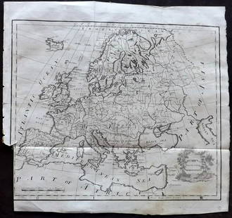
Sold2021Lochhead (Pub) 1811 Rare Map. EuropeCopper Engraved Map Published 1811 by William Lochhead, Berwick for "Modern Geography: And a Compendious General Gazetteer" Rare. Folds as issued. Paper Size: 12 x 10.5 inch (30 x 27cm) Some tone spotSee Sold Price
Sold2021Lochhead (Pub) 1811 Rare Map. ItalyCopper Engraved Map Published 1811 by William Lochhead, Berwick for "Modern Geography: And a Compendious General Gazetteer" Rare. Folds as issued. Paper Size: 10.5 x 10 inch (27 x 26cm) Very minor tonSee Sold Price
Sold2021Lochhead (Pub) 1811 Rare Map. England and WalesCopper Engraved Map Published 1811 by William Lochhead, Berwick for "Modern Geography: And a Compendious General Gazetteer" Rare. Folds as issued. Paper Size: 10.5 x 9.5 inch (27 x 24cm) Very minor toSee Sold Price
Sold2019Collins, William (Pub) C1870 Pair of HC Holy Land Maps"Geography of the Hebrews" and "Canaan in Possesion of the Twelve Tribes of Israel" Hand Coloured Steel Engraved Map Published C1870 by William Collins, London & Glasgow for "The Holy Bible" Paper SizSee Sold Price
Sold2021Lochhead (Pub) 1811 Rare Map. Netherlands Holland"The Severn United Provinces with the Dutch and Austrian Netherlands" Copper Engraved Map Published 1811 by William Lochhead, Berwick for "Modern Geography: And a Compendious General Gazetteer" Rare.See Sold Price
Sold2022Europe.- Brydone (Patrick) A Tour through Sicily and Malta. In a series of Letters to WilliamNO RESERVE Europe.- Brydone (Patrick) A Tour through Sicily and Malta. In a series of Letters to William Beckford, 2 vol., second edition, engraved folding map, occasional scattered spotting, slight bSee Sold Price
Sold2024Nat. Encyclo. 1890's Pair of Celestial Maps. Northern & Southern ConstellationsSteel Engraved Map Published 1891-1901 by William Mackenzie, London for "The National Encyclopedia: A dictionary of Universal Knowledge" Paper Size: 9.5 x 6 inch (24 x 16cm) Good ConditionSee Sold Price
6 days LeftForum AuctionsGeology.- Bristow (Henry William) The Geology of the Isle of Wight, hand-coloured maps, 1862 &£50
Freeman's | Hindman[MAPS - LOUISIANA - WAR OF 1812]. Maps of Louisiana, incl. Battle of New Orleans battle site map.$150(1 bid)
6 days LeftForum AuctionsTheocritus. Quae extant cum graecis scholiis, Oxford, 1699 & others, classical texts, many£300
6 days LeftForum AuctionsAfrica & African Printing.- McPherson (J.W.) The Moulids of Egypt. (Egyptian Saints-Days), first£100
5 days LeftEldred'sNICHOLAS SCULL & GEORGE HEAP’S ENGRAVED MAP OF PHILADELPHIA 1777 Sheet 16" x 13.25".$150
Jun 30Global Auctions CompanyHand Colored Engraved Map of Europe, Jean Baptiste Bourguignon Anville 1754$450
6 days LeftForum AuctionsCartography.- Cary (John) A New Map of England...1821, hand-coloured engraved map, 1823 & others£50
2 days LeftClaydon Auctioneers LtdMap: A 19thC engraved map titled Gloucestershire from the Best Authorities, after John Cary. Approx.£20
2 days LeftClaydon Auctioneers LtdMap: An 18thC engraved map of England and Wales, laid on linen and sectionalised with slip cover.£60
1 day LeftMynt AuctionsKing William Engraved by Tiffany and Co Sterling Silver Breakfast Fork w/Vine$10
5 days LeftBidhausKing William Engraved by Tiffany and Co Sterling Silver Crumber Bright-Cut Roses$10
2 days LeftClaydon Auctioneers LtdMap: A c1840 engraved map of England and Wales by J. & C. Walker of London, laid on linen and£80
2 days LeftClaydon Auctioneers LtdMap: A 19thC engraved map of England and Wales by J. Wyld, London, laid on linen, sectionalised and£90


![South America north west. Peru Bolivia Ecuador Columbia. HUGHES 1876 old map: Title: South America north west. Peru Bolivia Ecuador Columbia. HUGHES 1876 old map Description: [South America north west] by William Hughes (1876). Antique hand coloured engraved map, 30.0 x 24.5cm,](https://p1.liveauctioneers.com/5584/299901/159842110_1_x.jpg?height=310&quality=70&version=1693338270)


![[Maps & Atlases] Speed, John: The Turkish Empire (1 of 2)](https://p1.liveauctioneers.com/65/332523/179335176_1_x.jpg?height=282&quality=70&version=1717709446)

![[MAPS - LOUISIANA - WAR OF 1812]. Maps of Louisiana, incl. Battle of New Orleans battle site map. (1 of 7)](https://p1.liveauctioneers.com/197/333931/180433328_1_x.jpg?height=282&quality=70&version=1718838007)


