16th-20th Century Antiquarian Maps 2020-03-10 Auction - 177 Price Results - Jasper52 in NY - Page 3
LiveAuctioneers Logo

Township and Rail Road Map of the State of Iowa1802 Denon Atlas of Egypt Containing Maps, Views, etc.1855 Bachelder View of Manchester, NH -- A View of
Done
New York, NY, United States
Auction Details

16th-20th Century Antiquarian Maps

Jasper52

Jasper52

badge TOP RATED
Explore both land and sea with this array of maps, which preserves the geography of nearly every region imaginable. Unlike modern maps, these original engravings trace borders as they evolved throughout history. Discover centuries-old views of every corner of America, or a rare Denon Atlas from 1802! Not only will these maps serve as decorative pieces, but they also will reveal innumerable ways to view our world.
Auction Curator:
Steve Kovacs
Steve Kovacs
Maps Expert
Lot Number: Lowest
24
New York: Title: New York Publication Date: c1855 Cartographer: COLTON, J.H. Publisher: J.H. COLTON & CO. Size: 11.5 X 14.8 Additional Information: Bright clean map showing insets of Vicinity of Niagara Falls
0051: New YorkEst. $70-$80Lot Passed
Johnson's Iowa and Nebraska: Title: Johnson's Iowa and Nebraska Publication Date: c1864 Cartographer: JOHNSON, A.J. Publisher: A.J. Johnson Size: 15.5 X 22 Additional Information: Shows entire state of Iowa and the eastern part
0052: Johnson's Iowa and NebraskaEst. $70-$80Lot Passed
Johnson's Iowa and Nebraska: Title: Johnson's Iowa and Nebraska Publication Date: c1864 Cartographer: JOHNSON, A.J. Publisher: A.J. Johnson Size: 15.5 X 22 Additional Information: Map showing counties (w/districts separately
0053: Johnson's Iowa and NebraskaEst. $70-$80Lot Passed
Suisan Bay California: Title: Suisan Bay California Publication Date: 1872 Cartographer: BACHE, A.D./PIERCE, B. Publisher: U.S. COAST SURVEY Size: 17.5 X 32.5 Additional Information: Shows from karquines Straits to Sherman
0057: Suisan Bay CaliforniaEst. $90-$110Lot Passed
New Hampshire: Title: New Hampshire Publication Date: 1805 Cartographer: Arrowsmith & Lewis Publisher: Arrowsmith & Lewis Size: 9.8 X 8 Additional Information: Detailed. Shows topography, towns, townships, rivers,
0059: New HampshireEst. $110-$150Lot Passed
Sold
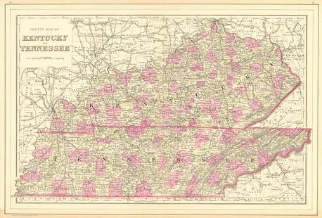
County Map of Kentucky and Tennessee: Title: County Map of Kentucky and Tennessee Publication Date: 1884 Cartographer: MITCHELL, S.A. Publisher: MITCHELL, S.A. Size: 13 X 20.8 Additional Information: Detailed map showing many townships,
0060: County Map of Kentucky and TennesseeEst. $70-$80
See Sold Price
New Mexico: Title: New Mexico Publication Date: c1890 Cartographer: CRAM Publisher: CRAM Size: 21.6 X 15.5 Additional Information: Details counties, towns, railroads (finished & unfinished), topography, roads,
0061: New MexicoEst. $110-$150Lot Passed
Minnesota: Title: Minnesota Publication Date: 1856 Cartographer: COLTON, JOSEPH HUTCHINS Publisher: J.H. COLTON & CO. Size: 12.75 X 16 Additional Information: Shows "Punished Woman L." in Yankton Country.
0065: MinnesotaEst. $90-$110Lot Passed
View:
24
TOP