Sold2022(MEXICO.) Robert Dudley. Carta Particolare della Parte Ocidentale della Nuova Spagnia, e del la(MEXICO.) Robert Dudley. Carta Particolare della Parte Ocidentale della Nuova Spagnia, e del la California. Large double-page engraved chart of the Pacific coast of Mexico and the southern tip of theSee Sold Price
Sold2018U.S Coast Survey 1853 Map. Gargathy Machipongo Inlet VA"Preliminary Chart of the Sea Coast of Virginia From Gagathy Inlet to Gr. Machipongo Inlet" Electrotype Map Published 1843-65, Washington for "Report of the Superintendent of the U.S. Coast Survey..."See Sold Price
Sold2018Antique 1856 US Coastal Survey of Martha's VineyardTitle/Content of Map: 1856 US Coastal Survey of Martha's Vineyard amd Nantucket Area in Massachusetts -- Preliminary Chart of Part of the Sea Coast of Massachusetts from Saughkonnet River to PlymouthSee Sold Price
Sold2024CHART "SOUTHERN COAST OF LONG ISLAND FROM MONTAUK POINT TO EAST HAMPTON" Circa 1877 11.25" x 22.75"CHART "SOUTHERN COAST OF LONG ISLAND FROM MONTAUK POINT TO EAST HAMPTON"Circa 187711.25" x 22.75" sight. Framed 16.75" x 28". Provenance:An Important Connecticut Collection.See Sold Price
Sold2023Nautical Chart: SOUTHERN COAST OF LONG ISLAND SOUND/ MONTAUK POINT TO EAST HAMPTONDescription: SOUTHERN COAST OF LONG ISLAND SOUND/ FROM MONTAUK POINT TO EAST HAMPTON Measurement approximate: 32 x 22 InchesMaterial: PaperSee Sold Price
Sold2021Antique Coast Survey Map of the Atchafalaya BayAntique Coast Survey Map of the Atchafalaya Bay , "Preliminary Chart of Atchafalaya Bay Louisiana... A.D. Bache, Superintendant", 1858, lithograph, with later hand-coloring, sight 24 1/2 in. x 31 1/4See Sold Price
Sold2021Preliminary Chart of Nantucket Shoals"Preliminary Chart of Nantucket Shoals", from a trigonometrical survey under the direction of A.D. Bache Superintendent of the Survey of the coast of the United States, 1864 23.5 in. x 19.5 in. FramedSee Sold Price
Sold2021(D No. 3) Preliminary chart of the Entrances to CapePublication Date: 1854 Title: (D No. 3) Preliminary chart of the Entrances to Cape Fear River and New Inlet North Carolina Cartographer: C.P. Bolles Publisher: U.S. Coast Survey / Robert Armstrong HeiSee Sold Price
Sold2021(D. No.3) Preliminary Chart of lower part of Cape FearPublication Date: 1855 Title: (D. No.3) Preliminary Chart of lower part of Cape Fear River North Carolina Cartographer: C.P. Bolles Publisher: U.S. Coast Survey Height: 30.5 Width: 25.5 From a trigonoSee Sold Price
Sold2020(Sketch F, No.5) Preliminary Chart of Key West HarborTitle/Content of Map: (Sketch F, No.5) Preliminary Chart of Key West Harbor and Approaches... 1851 Publication Date: 1851 Cartographer: KNORR, E. K./ISSAC HULL ADAMS Publisher: U.S. COAST SURVEY DescrSee Sold Price
Sold20201858 US Coast Survey Map of Charleston Harbor --Title/Content of Map: 1858 US Coast Survey Map of Charleston Harbor -- Preliminary Chart of Charleston Harbor and Its Approaches from a Trigonometrical Survey Under the Direction of A.D. Bache… CartSee Sold Price
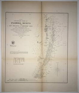
Sold2020(F No.4) Preliminary Chart of Florida Reefs from KeyTitle/Content of Map: (F No.4) Preliminary Chart of Florida Reefs from Key Biscayne to Carysfort Reef... Publication Date: 1855 Cartographer: Totten, Jas./I. Hull Adams Publisher: U.S. Coast Survey DeSee Sold Price
Sold2020Central America Caribbean Gulf of Mexico chart PortsTITLE/CONTENT OF MAP: 'Central American and West Indian Ports; Inset The Pacific Coast from San Diego to Vancouver; San Francisco; Aleutian; The Pacific Coast from Seattle to Dutch Harbor; Bermudas; KSee Sold Price
Sold2018U.S Coast Survey 1853 Map. Ship Island Shoal, Louisiana"Preliminary Chart of Ship Island Shoal Louisiana" Electrotype Map Published 1843-65, Washington for "Report of the Superintendent of the U.S. Coast Survey..." Published under the supervision and direSee Sold Price
Sold2023U S Coast Survey 1856 Large Map. St. Mary's Bar & Fernandina Harbor Florida"Preliminary Chart of St. Mary's Bar and Fernandina Harbor Florida"Large Lithograph Map Published 1857, Washington for "U.S. Coast and Geodetic Survey" Folds as issued. Paper Size: 25 x 23 inch (64 xSee Sold Price
Sold2021Three South Carolina MapsPreliminary Chart of Port Royal Entrance, Beaufort Chechessee and Colleton Rivers... U.S. Coast Survey Office, Superintendent A. D. Bache, triangulation by C. O. Boutelle... 1859, single sheet, engravSee Sold Price
Sold2017(lot of 34) Beer tap handles, including Coronado(lot of 34) Beer tap handles, including Coronado Brewing, Pilsner Urquell, Saint Archer, Mission, Sierra Nevada, Ballast Point Brewing, Modelo, etc., largest: 12"l. Property from Pacific Coast BrewingSee Sold Price
Sold2020Sketch J No.4 Indicating Proposed Sites for aTitle: Sketch J No.4 Indicating Proposed Sites for a Light-House On Point Pinos Bay of Monterey Publication Date: 1853 Cartographer: Harrison, A. M. Publisher: U.S. Coast Survey Size: 7.6 X 9 AdditionSee Sold Price
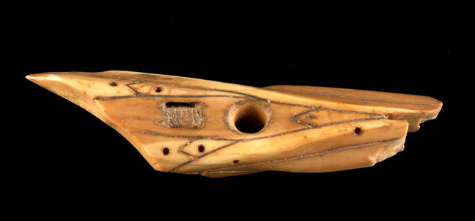
Sold2022Pre-Contact Inuit Walrus Ivory Harpoon PointNative American, North America, Pacific Northwest Coast, Alaska, St. Lawrence Island, Inuit, Punuk stage, ca. 500 to 1000 CE. A hand-carved walrus ivory harpoon point of an elongated triangular form wSee Sold Price
Sold2019A.D. Bache U.S. Coast Survey Charts East CoastA.D. Bache: Preliminary Coastal Chart N. 8, Sequin Island to Kennebunkport, Maine 1859. Measures 38” X 22”. Paper size 40" x 24 1/2". Used Condition, creases, burn. electrotype have some sSee Sold Price
Sold2023NAUTICAL CHART/ CONNECTICUT NEW YORK. NORTH SHORE OF LONG ISLAND SOUND GREENWICH POINT TO NEWDescription: NAUTICAL CHART EAST COAST/ CONNECTICUT – NEW YORK. NORTH SHORE OF LONG ISLAND SOUND GREENWICH POINT TO NEW ROCHELLE. Published at Washington D.C/ JUNE 1939 (6TH Edition) First editSee Sold Price
Sold2023NAUTICAL CHART/ CONNECTICUT NEW YORK. NORTH SHORE OF LONG ISLAND SOUND GREENWICH POINT TO NEWDescription: NAUTICAL CHART EAST COAST/ CONNECTICUT – NEW YORK. NORTH SHORE OF LONG ISLAND SOUND GREENWICH POINT TO NEW ROCHELLE. Published at Washington D.C/ JUNE 1939 (6TH Edition) First editSee Sold Price
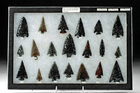
Sold202120 Late 19th C. Northwest Coast Obsidian Points**Originally Listed At $200** Native American, Pacific Northwest Coast, ca. late 19th to early 20th century CE. A fine ensemble of 20 hand-knapped obsidian points of semi-translucent or opaque black hSee Sold Price
Sold202318 Native American Pacific Northwest Obsidian Points**Originally Listed At $200** Native American, Pacific Northwest Coast, ca. 19th century CE. A fine collection of 18 hand-knapped projectile points made from black obsidian and slate. The collection hSee Sold Price
2 days LeftJasper52Central America Caribbean Gulf of Mexico chart Ports lighthouses LARGE 1918 map$45
2 days LeftJasper52Jamaica SE coast Morant-Portland Pt Kingston ADMIRALTY sea chart 1963 (1971) map$120
5 days LeftThomaston Place Auction Galleries(2) FINE NORTHWEST PACIFIC COAST INDIAN BASKETS$100(1 bid)
6 days LeftGold Coast AuctioneersLg Hallmark Lionel Train Ornament Collection of 74 Santa Fe F3A$75(2 bids)
17 hrs LeftFreeman's | Hindman[Maps & Atlases] A New Map of North America, with the West India Islands...$300
3 days LeftRail & Road AuctionsRailroad Matchbook Collection - Santa Fe, Illinois Central, Cotton Belt Route, Nickel Plate Road,$20(1 bid)
4 days LeftRail & Road AuctionsLarge Group of Collectible Railroad Train Plates and Plaques - Pennsbury Pottery, Wilton Armetale,$40


![[Maps & Atlases] A New Map of North America, with the West India Islands... (1 of 2)](https://p1.liveauctioneers.com/65/332523/179335173_1_x.jpg?height=282&quality=70&version=1717709447)


