


Done
New York, NY, United States
Auction Details
Charting the Past: Exclusive Antique Maps
Chairish Auctions
Embark on a Visual Odyssey through Time! Welcome to 'Charting the Past: Premium Antique Maps' auction, where history comes alive through intricate lines and exquisite details. Delve into a captivating collection of cartographic masterpieces that have navigated the ages, guiding generations through uncharted territories and distant horizons. Each map tells a tale of exploration, adventure, and the evolving world as seen through the eyes of intrepid cartographers. Immerse yourself in the artistry of ages past, where every stroke of ink on parchment captures the spirit of discovery and the evolution of geographic knowledge
LiveAuctioneers Purchase Protection
Get the confidence you need to bid on the items you love.Learn More
Complete payment via LiveAuctioneers to qualify.

0001: CHAMPAGNE VINEYARD MAP Montagne de Reims. Éperon de Bouzy. Mailly. LARMAT 1944Est. $550-$700Lot Passed

0002: Océanique Partie de la Nle Zélande 60 New Zealand South Is VANDERMAELEN 1827 mapEst. $700-$800Lot Passed
Sold

0003: North America by John Thomson. Forts, Missions & Indian settlements 1817 mapEst. $500-$600
![LSE POVERTY OS PROOF MAP Swiss Cottage. West/South Hampstead. Belsize Park 1928: Title: LSE POVERTY OS PROOF MAP Swiss Cottage. West/South Hampstead. Belsize Park 1928Description: [Ordnance Survey] Edition of 1915 - London Sheet IV. 4. Middlesex Sheet XVI. 4. Swiss Cottage -](https://p1.liveauctioneers.com/5584/299315/159320041_1_x.jpg?height=310&quality=70&version=1692738247)
0004: LSE POVERTY OS PROOF MAP Swiss Cottage. West/South Hampstead. Belsize Park 1928Est. $2,000-$2,500Lot Passed
![Plan of Rome / Topographia di Roma. ROCQUE, from NOLLI's earlier map 1750: Title: Plan of Rome / Topographia di Roma. ROCQUE, from NOLLI's earlier map 1750Description: Plan of Rome / Topographia di Roma [Plan of Rome]' by John Rocque / Giovanni Battista Nolli (Published in](https://p1.liveauctioneers.com/5584/299315/159320042_1_x.jpg?height=310&quality=70&version=1692738247)
0005: Plan of Rome / Topographia di Roma. ROCQUE, from NOLLI's earlier map 1750Est. $1,500-$2,000Lot Passed

0006: Océanique. Partie de l'ile de Java #27 Bali Lombok Sumbawa VANDERMAELEN 1827 mapEst. $600-$700Lot Passed

0007: Océanique. Partie de la Nlle Hollande #37 Carpentaria Gulf VANDERMAELEN 1827 mapEst. $700-$800Lot Passed

0008: Plan of the bay, rock and town of Gibraltar... Spanish Army 1782. FADEN 1783 mapEst. $500-$600Lot Passed

0009: Océanique. Partie des Iles Philippines #6 Visayas Mindanao VANDERMAELEN 1827 mapEst. $700-$800Lot Passed
![Océanique. Partie de la Nle Hollande #44 Western Australia VANDERMAELEN 1827 map: Title: Océanique. Partie de la Nle Hollande #44 Western Australia VANDERMAELEN 1827 mapDescription: Océanique - Partie de la Nouvelle Hollande [Note sur la nouvelle Hollande] - No. 44 by](https://p1.liveauctioneers.com/5584/299315/159320047_1_x.jpg?height=310&quality=70&version=1692738247)
0010: Océanique. Partie de la Nle Hollande #44 Western Australia VANDERMAELEN 1827 mapEst. $700-$800Lot Passed
![Océanique. Partie… Nlle Hollande #54 South Australia coast VANDERMAELEN 1827 map: Title: Océanique. Partie… Nlle Hollande #54 South Australia coast VANDERMAELEN 1827 mapDescription: Océanique - Partie de la Nouvelle Hollande [Note sur la nouvelle Hollande] - No. 54](https://p1.liveauctioneers.com/5584/299315/159320048_1_x.jpg?height=310&quality=70&version=1692738247)
0011: Océanique. Partie… Nlle Hollande #54 South Australia coast VANDERMAELEN 1827 mapEst. $800-$1,000Lot Passed


0013: Birman Empire. Burma Myanmar. Western Siam/Thailand Bengal. THOMSON 1830 mapEst. $600-$700Lot Passed
![Navigation chart & view of LEITH, by Capt Greenvile COLLINS. Edinburgh 1723 map: Title: Navigation chart & view of LEITH, by Capt Greenvile COLLINS. Edinburgh 1723 mapDescription: [Leith]; Prospect of Leith from the east - To the Right Honourable Sr. James Fleming, Lord Provost](https://p1.liveauctioneers.com/5584/299315/159320051_1_x.jpg?height=310&quality=70&version=1692738247)
0014: Navigation chart & view of LEITH, by Capt Greenvile COLLINS. Edinburgh 1723 mapEst. $450-$550Lot Passed
![Il Principato delle Asturie. Principality of Asturias. ROSSI / CANTELLI 1696 map: Title: Il Principato delle Asturie. Principality of Asturias. ROSSI / CANTELLI 1696 mapDescription: Il Principato delle Asturie [The Principality of Asturias] by Published by Giovanni Giacomo de](https://p1.liveauctioneers.com/5584/299315/159320052_1_x.jpg?height=310&quality=70&version=1692738247)
0015: Il Principato delle Asturie. Principality of Asturias. ROSSI / CANTELLI 1696 mapEst. $450-$550Lot Passed
![Spanish North America. THOMSON. Texas, Mexico & Southwestern USA 1830 map: Title: "Spanish North America". THOMSON. Texas, Mexico & Southwestern USA 1830 mapDescription: Spanish North America [northern part] by Drawn & engraved for John Thomson's "New General Atlas" (1830).](https://p1.liveauctioneers.com/5584/299315/159320053_1_x.jpg?height=310&quality=70&version=1692738247)
0016: Spanish North America. THOMSON. Texas, Mexico & Southwestern USA 1830 mapEst. $800-$1,000Lot Passed

0017: London in 1897 with street improvements since 1855. 80x105 cm. Edwards 1898 mapEst. $450-$550Lot Passed
![Il Lazio. West sheet. Lazio coast from the Tiber to Anzio. Rome. ROSSI 1693 map: Title: Il Lazio. West sheet. Lazio coast from the Tiber to Anzio. Rome. ROSSI 1693 mapDescription: Il Lazio [West sheet] [Lazio - west sheet] by Published by Giovanni Giacomo de Rossi. descritto da](https://p1.liveauctioneers.com/5584/299315/159320055_1_x.jpg?height=310&quality=70&version=1692738247)
0018: Il Lazio. West sheet. Lazio coast from the Tiber to Anzio. Rome. ROSSI 1693 mapEst. $500-$600Lot Passed

0019: York racecourse, Yorkshire. Knavesmire. BAYLES 1903 old antique map plan chartEst. $450-$550Lot Passed

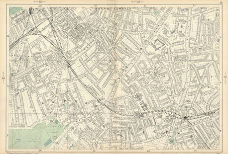
0020: HACKNEY Charles Booth poverty map Clapton Dalston Homerton London Fields 1902Est. $700-$800Lot Passed
![Descrittione dell' Isola di Cipro. PORCACCHI. Cyprus 1590 old antique map: Title: Descrittione dell' Isola di Cipro. PORCACCHI. Cyprus 1590 old antique mapDescription: Descrittione dell' Isola di Cipro [Description of the island of Cyprus] by Tomaso Porcacchi (1590).](https://p1.liveauctioneers.com/5584/299315/159320058_1_x.jpg?height=310&quality=70&version=1692738247)
0021: Descrittione dell' Isola di Cipro. PORCACCHI. Cyprus 1590 old antique mapEst. $550-$700Lot Passed
0022: CLAPHAM Common/North Brixton Lambeth Stockwell Battersea Wandsworth 1900 mapEst. $500-$600Lot Passed

0023: Cape Cod, Nantucket & Martha's Vineyard. Barnstable Dukes. WALLING GRAY 1871 mapEst. $400-$500Lot Passed
![Tartaria d'Europa overo Piccola Tartaria. Little Tartary. Ukraine ROSSI 1684 map: Title: Tartaria d'Europa overo Piccola Tartaria. Little Tartary. Ukraine ROSSI 1684 mapDescription: Tartaria d'Europa overo Piccola Tartaria [European, or Little Tartary] by Published by Giovanni](https://p1.liveauctioneers.com/5584/299315/159320061_1_x.jpg?height=310&quality=70&version=1692738247)
0024: Tartaria d'Europa overo Piccola Tartaria. Little Tartary. Ukraine ROSSI 1684 mapEst. $700-$800Lot Passed
Auction Details

Bid Increments
PriceBid Increment
$0$1
$10$5
$100$10
$200$20
$500$50
$1,000$100
$2,000$200
$5,000$500
$10,000$1,000
$20,000$2,000
Preview
This preview is online only.
New York, NY 10016
USA
Buyer's Premium
- 15%
Terms & Conditions
1. All bidders and buyers shall present satisfying documentation prior to the approval of this auction.
2. This auction contains items with 'no reserve' or 'reserve' pricing, as indicated in each item description. An item with 'no reserve' means there is no minimum price set, so the item is guaranteed to sell regardless of what the winning bid price is. An item containing a 'reserve' means that there is a minimum price that the bidding must reach to sell.
3. All property is sold 'as is' and neither Jasper52 nor the listing agent makes any warranties or representation or any kind or nature with respect to the property, and in no event shall they be responsible for the correctness, nor deemed to have made any representation or warranty, or description, genuineness, authorship, attribution, provenance, period, culture, source, origin, or condition of the property and no statement made at the sale, or in the bill of sale, or invoice, or in the catalog, or elsewhere shall be deemed such a warranty of representation or an assumption of liability. Prospective buyers are urged to inspect those lots in which they have an interest.
4. Jasper52 will contact the winning bidders with shipping information after the auction. Buyer pays shipping cost indicated in the auction description, as well as any applicable taxes, duties or fees for items originating from outside of the buyer's home country. For buyer's outside of the Continental United States, the Jasper52 team will provide an introduction to global parcel or white glove shipping partners upon request.
5. Except as provided in paragraph 1 above, the highest bidder as determined by Jasper52 shall be the purchaser. In the case of a disputed bid, the auctioneer shall have sole discretion in determining the purchaser and may also, at his or her election, withdraw the lot or reoffer the lot for sale. The auctioneer shall have sole discretion to refuse any bid, or refuse to acknowledge any bidder.
6. All merchandise purchased is payable directly to Jasper52 and must be paid for upon receipt of the invoice. Invoices are sent the day after the auction.. All merchandise must be removed from Jasper52 within fourteen business days of the auction, and in no event shall Jasper52 have any liability for any damage to property left on its premises for more than fourteen business days after the sale. If any property has not been removed within fourteen business days from the date of sale, at the option of Jasper52 (a) the merchandise may be transferred to and stored at a bonded warehouse and the purchaser agrees to pay all transfer and storage expenses, and/or (b) Jasper52 may place the merchandise in a subsequent auction, without reserve, to be sold to the highest bidder, and after deducting the standard commission and any additional charges that may apply, remit the proceeds to the purchaser.
7. Acceptable forms of payment are VISA, MasterCard, American Express, or Discover, payable in U.S. dollars. Invoice must be paid in full. Jasper52 reserves the right to hold merchandise purchased until the funds have cleared.
8. If the purchaser breaches any of its obligations under these Conditions of Sale, including its obligation to pay in full the purchase price of all items for which it was the highest successful bidder, Jasper52 may exercise all of its rights and remedies under the law including, without limitation, (a) canceling the sale and applying any payments made by the purchaser to the damages caused by the purchaser's breach, and/or (b) offering at public auction, without reserve, any lot or item for which the purchaser has breached any of its obligations, including its obligation to pay in full the purchase price, holding the purchaser liable for any deficiency plus all costs of sale.
9. Jasper52 may, in its discretion and at purchaser's request, package and arrange for delivery as directed by the purchaser. In such event, purchaser agrees that (a) all such packaging, handling and delivery is at the sole risk of the purchaser and that Jasper52 shall have no liability for any loss or damage to such items, and (b) purchaser shall pay in advance, all packaging expenses, including labor, materials, carrier's fees and all insurance charges. Please arrange seventy-two hours in advance for collection and delivery. Jasper52 shall not be responsible for obtaining any permits or licenses on behalf of purchaser and no sale shall be cancelled or refunded for lack of purchaser's noncompliance with permitting and licensing issues. JASPER52 WILL NOT CANCEL SALE DUE TO SHIPPING. Should items be returned to the Jasper52 listing agent due to incorrect address provided at checkout or shipping errors, the buyer will be obligated to make a 2nd payment for shipping, and will be liable for other fees and taxes that were associated with the lot(s) being directed back. Should the buyer not honor the obligation, they will violate the terms of the sale. Should the buyer want to be released from the sale after the initial payment, it is at Jasper52's discretion to honor that request. However, the shipping cost and excess fees would be withheld from the refund as services rendered.
10. A premium equal to 15% of the final bid price will be applied to each lot sold, to be paid by the buyer as part of the purchase price.
11. Bidding on any item indicates your acceptance of these terms and all other terms printed within, posted, and announced at the time of sale.
12. All sales are final and no refunds will be granted.
13. When you win an item, we will send you an invoice for it. If you have a credit card on file with LiveAuctioneers, it will be charged the balance on the invoice 24 hours after the invoice is sent.
Autopay
This auction uses Autopay by LiveAuctioneers. If you place a winning bid, your card will be charged shortly after the conclusion of the auction.
Sales Tax
Online purchases from Jasper52 may be subject to sales tax. Please see the following for more details. If you are tax-exempt, you can submit your tax-exempt certificate to prevent the collection of tax. Learn more about tax-exemption.
TOP