![(NATURAL HISTORY.) John Gould. A Monograph of the Ramphastidae, or Family of Toucans. [Bound with:]](https://p1.liveauctioneers.com/199/309980/165834109_1_x.jpg?height=300&quality=70&version=1700151649)


Done
New York, NY, United States
Auction Details
Maps & Atlases
This December sale is set to include a wide assortment of maps and graphics chronicling the advancement of knowledge of the world from the sixteenth through the twentieth century. Featured themes will be maps of the American continent from its early colonial settlement, the Revolutionary War. The period of growth and expansion in the West, all the way to some of the earliest established commercial airline flight paths in 1929.
Highlights include a set of unassembled engraved gore segments which construct Vincenzo Coronelli?s enormous 42-inch terrestrial globe from 1688. Several unique manuscript maps will also be on offer, including a neatly detailed hand-drawn account of an extensive hike from New York City through New Jersey and eastern Pennsylvania in the summers of 1860 and 1861 by a recent engineering graduate of the Brooklyn Collegiate Polytechnic Institute, only months before beginning his career as a Navy paymaster during the Civil War.
Auction Curator:
Caleb Kiffer
Specialist, Maps & AtlasesSold

0001: (AFRICA.) S. Boulton; after Jean-Baptiste Bourguignon d'Anville. Africa, with all its StatesEst. $800-$1,200
![(AFRICA.) Group of 19 sixteenth-to-nineteenth-century engraved maps.: (AFRICA.) Group of 19 sixteenth-to-nineteenth-century engraved maps. Vp, vd - Laurent Fries. [Tabula II Aphricae]. Double-page woodcut map of north Africa and several Mediterranean islands. 16x21](https://p1.liveauctioneers.com/199/309980/165833880_1_x.jpg?height=310&quality=70&version=1700151649)
Sold

0003: (ALASKA.) Constantine Grewingk. Karte zur Abhandlung Uber die Geogn. U. Orogr. Beschaffenheit derEst. $500-$700

0004: (ALASKA.) British Admiralty and Hydrographic Office. America West Coast - Sitka or New Arkhangel.Est. $800-$1,200Lot Passed
![(AMERICAN REVOLUTION.) The Theatre of War in North America,: (AMERICAN REVOLUTION.) The Theatre of War in North America, with the Roads, and Tables, of the Superficial Contents, Distances, &ca. By An American. [On a sheet with]: A Compendious Account of the](https://p1.liveauctioneers.com/199/309980/165833883_1_x.jpg?height=310&quality=70&version=1700151649)
Sold

0006: (AMERICAN SOUTHEAST.) Johannes van Keulen. Pas Kaart van de Kust van Carolina Tusschen C deEst. $1,500-$2,500

0007: (AMERICAN SOUTHWEST.) U.S. Army Corps of Engineers; and U.S. Geological Survey. Key Map ShowingEst. $800-$1,200Lot Passed
Sold
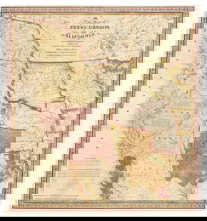
0008: (AMERICAN WEST.) Samuel Augustus Mitchell. A New Map of Texas, Oregon and California with theEst. $3,500-$5,000
Sold

0009: (AMERICAN WEST.) John Charles Fremont. Map of an Exploring Expedition to the Rocky Mountains in theEst. $600-$900
Sold

0010: (ARIZONA -- MINING.) F.W. Boyer; and Richard T. Belcher. Map Showing Location of the Jerome-PhoenixEst. $600-$900
Sold

0011: (ASIA.) Sebastian Münster. Die Lander Asie Nach Ihrer Gelegenheit Bisz in Indiam.Est. $500-$700
Sold

0012: (ASIA.) John Speed. Asia with the Islands Adjoyning Described, the Atire of the People, & Townes ofEst. $1,000-$1,500
Sold

0013: (ASIA.) Robert Sayer; after Jean-Baptiste Bourguignon d'Anville. Asia According to the SieurEst. $600-$900

Sold

0015: (ASIA.) J.B. Roost, Eduard Gronen, and Carl Friedrich Wenng. Wand-Karte von Asien, Europa u. derEst. $600-$900

Sold

0017: (AVIATION.) C.S. Hammond & Co.; and The Pittsburgh Press. Our Flying Ambassadors and Their Routes.Est. $600-$900
Sold

0018: (AVIATION -- AERONAUTICAL PLANNING CHARTS.) U.S. Coast and Geodetic Survey; and others. Group ofEst. $600-$900

Sold

0020: (BALKANS.) Cornelis de Jode. Illirici seu Sclavoniae, Continentis Croatiam, Carniam, Istriam,Est. $700-$1,000

0021: (BALTICS.) Joseph Nicholas de L'Isle. Ducatuum Estoniae et Livoniae Tabula cum Cursu Fluvii Dwinae.Est. $500-$700Lot Passed


Auction Details

Bid Increments
PriceBid Increment
$0$10
$150$25
$500$50
$1,000$100
$2,000$200
$6,000$500
$10,000$1,000
$20,000$2,000
$50,000$5,000
$100,000$10,000
$200,000$20,000
$500,000$50,000
$1,000,000$100,000
TOP