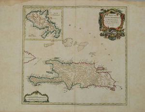
Sold20201750 Robert de Vangondy Map of Hispaniola andTitle/Content of Map: 1750 Robert de Vangondy Map of Hispaniola and Martinique -- Isles de Saint Domingue ou Hispaniola, et de la Martinique Cartographer: G Robert de Vaugondy Year/Place: 1750, ParisSee Sold Price
Sold20211750 Robert de Vaugondy Map of Russia in Large Part --Title: 1750 Robert de Vaugondy Map of Russia in Large Part -- Partie Occidentale de l'Empire de Russie ou se trouve distinguee la Russie Europeenne … Cartographer: D Robert de Vaugondy Year / Place:See Sold Price
Sold20221750 Robert de Vaugondy Map of Russian Empire -- PartieTitle: 1750 Robert de Vaugondy Map of Russian Empire -- Partie Occidentale de l'Empire de Russie, ou se Trouve Distinguee la Russie Europeenne… Cartographer: D Robert de Vaugondy Year/Place: 175See Sold Price
Sold2020de Vaugondy / la Porte: Isle de St. Domingue, 1806L’Abbé de la Porte's 1806 edition of Robert de Vaugondy's detailed Atlas Portatif map of Hispaniola showing the island united under the French and divided into 5 departements, from de la Porte'See Sold Price
Sold2020Amerique Septentrionale.Amerique Septentrionale. Hand-colored engraved map by Robert de Vaugondy, 1750 18.75" x 23" Frame: 29" x 33.75"See Sold Price
Sold2021French Hand-Colored Map of America, 1750Antique French Hand-Colored Map of America , "Amerique Septentrionale, dressee, sur les Relations les plus modernes...", 1750, Robert de Vaugondy, the cartouche with an alligator flanked by figures, 1See Sold Price
Sold2023Amérique Méridionale. South America. ROBERT DE VAUGONDY 1750 old antique mapTitle: "Amérique Méridionale". South America. ROBERT DE VAUGONDY 1750 old antique map Description: Amérique Méridionale, dressée, sur les Mémoires les plus récents et assujétieSee Sold Price
Sold2015Map of Spain, Robert de VaugondyHispania Antiqua map of Spain. Robert de Vaugondy, 1750. [Sight: 19 1/4" x 22 1/2"; Frame: 25 1/2" H x 29" W]. Frame missing glass. Creases and water damage.See Sold Price
Sold20164 Maps: 1760 N. Am.; Botanic Geo.; Eur.; OK Terr.Four Antique Maps; a French 1760 Map of North American ''AMÉRIQUE SEPTENTRIONALE...1750'' Paris: S. Robert De Vaugondy, c. 1750 (1st edition, dated in the cartouche; "Outlines of Botanical Geography"See Sold Price
Sold2021ROBERT DE VAUGONDY MAP OF SOUTH AMERICA, C. 1750Robert de Vaugondy (French, 1686-1766). "Amerique Meridionale" -1750, engraving with hand coloring. Approx. 20" x 24.75' (sheet)See Sold Price
Sold2017Vaugondy: Antique Map of Western Hemisphere, 1750sTitle/Content of Map: 1750's Western Hemisphere Date Printed: 1750's Cartographer: Robert de Vaugondy Material/Medium: Paper Size: 6" x 8" Hand colored copperplate engraved. Published in Paris. GillesSee Sold Price
Sold2020Map, Robert de VaugondyRobert de Vaugondy (French, 1688-1766), "Royaume d'Irlande divise en ses quatre Provinces," 1750, hand-colored engraving, sight (image): 19.5"h x 21.5"w, overall (with frame): 27"h x 29"w. Provenance:See Sold Price
Sold2021Map- Robert de Vaugondy (1723-1786, French). "AmeriqueMap- Robert de Vaugondy (1723-1786, French) "Amerique Septentrionale," 1750, hand colored, with a cartouche of Tropical plants, natives and wildlife surrounding the title, shrink wrapped, H.- 21 3/8 iSee Sold Price
Sold2018Carte du nouveau continentTitle/Content of Map: Carte du nouveau continent Date: 1750 ca. Cartographer: Didier Robert de Vaugondy Size: 7.25X5.75 Selon sa plus grande longueur diametrale depuis la Riviere de la Plata jusqu�See Sold Price
Sold2018AsieMap: Asie Date: 1750 Cartographer: ROBERT DE VAUGONDY, GILLES Size (inches): 5.8X6.3 "Par le Sr. Robert de Vaugondy, avec privilege 1750." No.14 of a series used in a geography. On polar projection. SSee Sold Price
Sold2018AsieMap: Asie Date: 1750 Cartographer: ROBERT DE VAUGONDY, GILLES Size (inches): 5.8X6.3 "Par le Sr. Robert de Vaugondy, avec privilege 1750." No.14 of a series used in a geography. On polar projection. SSee Sold Price
Sold2018AsieTitle/Content of Map: Asie Date: 1750 Cartographer: ROBERT DE VAUGONDY, GILLES Size: 5.8X6.1 "Par le Sr. Robert de Vaugondy, avec privilege 1750." Please note that this lot has a confidential reserve.See Sold Price
Sold2019PologneTitle/Content of Map: Pologne Date: 1762 Cartographer: ROBERT DE VAUGONDY, GILLES | MEUNIER, sc. Size: 6Height - 6.75Width Par le Sr. Robert de Vaugondy, avec privilege 1750. No. 11 of a series used iSee Sold Price
Sold2023AFTER NICOLAS SANSON (FRENCH, 1600-1667) MAP OF GREAT BRITAINAFTER NICOLAS SANSON (FRENCH, 1600-1667) MAP OF GREAT BRITAIN, hand-colored engraving on laid paper, engraving by Robert De Vaugondy. Unframed. Circa 1750. 21 3/4" x 31". Provenance: BSee Sold Price
Sold2018de Vaugondy: Hispaniola and MartiniqueMap: Isles de Saint Domingue ou Hispaniola et de la Martinique. Cartographer: Gilles Robert de Vaugondy Place/Date: Paris / 1750 Size: 20 1/4" x 19" Condition: outline color/b&w cartouche; overall ageSee Sold Price
Sold2017Vaugondy: Antique Map of Europe, 1750Map: L'europe Publication Date: 1750 Authors: ROBERT DE VAUGONDY, DIDIER Size: Miniature – 5.75 H x 5.80 W Inches Par le Sr. Robert de Vaugondy avec privilege du roi 1750. Page 55 of a series used iSee Sold Price
Sold2018Robert de Vaugondy: Hispaniola with Martinique InsetReserve Reduced! Map Title: Isles de Saint Domingue ou Hispaniola et de la Martinique. Cartographer: Gilles Robert de Vaugondy Place / Date: Paris / 1750 Size: 20 1/4" x 19" Condition: outline color/bSee Sold Price
Sold2019Gilles Robert de Vaugondy: Hispaniola and MartiniqueMap Title: Isles de Saint Domingue ou Hispaniola et de la Martinique. Cartographer: Gilles Robert de Vaugondy Place/Date: Paris / 1750 Size: 20 1/4" x 19" Condition: outline color/b&w cartouche; lightSee Sold Price
Sold2018A Hand Colored Map on Laid Paper of 'Royaume D'Irlande'A Hand Colored Map on Laid Paper of 'Royaume D'Irlande' by Gilles Robert de Vaugondy (1688-1766), Published in Paris, ca. 1750. Framed dimensions: h: 29 1/4 x w: 30 5/8 in. H: 19 14 W: 21 1/2 in. TheSee Sold Price
2 days LeftJasper52Antique Felix Delamarche Vaugondy Mappemonde Double hemisphere world map 1838US$45
2 days LeftJasper52Antique French Engraving Felix Delamarche set of celestial and solar system 1838US$60
6 days LeftTrillium Antique Prints & Rare BooksPrevost - Pair of Engravings of Santo Domingo or HispaniolaUS$50
6 days LeftMynt AuctionsRobert De Niro Signed Book Photo Raging Bull Jake Lamotta Vintage Full SigUS$10
Jun 14DuMouchellesRigobert Bonne (French, 1727-1794) Hand Colored Engraving Ca. 18th Century, Les Etats Unis DeUS$50


![Map of Spain, Robert de Vaugondy: Hispania Antiqua map of Spain. Robert de Vaugondy, 1750. [Sight: 19 1/4" x 22 1/2"; Frame: 25 1/2" H x 29" W]. Frame missing glass. Creases and water damage.](https://p1.liveauctioneers.com/1221/80855/42002881_1_x.jpg?height=310&quality=70&version=1445535329)


