Sold20231831 SDUK Map of Bengal / Bangladesh -- India Bengal PresidencyTitle: 1831 SDUK Map of Bengal / Bangladesh -- India Bengal Presidency Cartographer: SDUK Year / Place: 1831, London Map Dimension (in.): 14 X 10.2 in. This is a very nice map of the Ganges and BrahmaSee Sold Price
Sold2021Nolan, Edward C1880 Pair of Maps of India"India. The Bombay Presidency/India. The Madras Presidency" and "India The Bengal Presidency" Steel Engraved Map Published C1880, London for "The Illustrated History of the British Empire in India andSee Sold Price
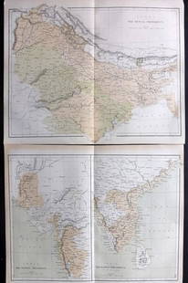
Sold2022India Bengal PresidencyPublication Date: 1831-06-01 Title: India Bengal Presidency Cartographer: WALKER, J. & C. Publisher: Baldwin & Cradock/S.D.U.K. Height: 14.2 Width: 10.25 Later index calls this "India VIII". Reserve:See Sold Price
Sold2017India/Bengal Presidency Rupee Yr 45India/Bengal Presidency British India, Shah Alam II, Rupee, (KM.77), Year 45, NGC MS62.See Sold Price
Sold2023India Rupee ND-//19India British India, Bengal Presidency, Rupee, (KM.108), ND-//19, hairlines, bagmarks, EF.See Sold Price
Sold2023India Rupee AH-//19India British India, Bengal Presidency, Rupee, (KM.99), AH-//19, hairlines, bagmarks, foreign substance, VF.See Sold Price
Sold2019Bryce, James 1881 Map of Bengal, IndiaLithograph Map Published 1881, London for ""The International Atlas and Geography..." by James Bryce. Maps by Edward Weller & John Bartholomew. Uncommon. Paper Size: 18 x 13 inch (46 x 33cm) Good CondSee Sold Price
Sold2018Bryce, James 1881 Map of Lower Bengal, IndiaLithograph Map Published 1881, London for ""The International Atlas and Geography..." by James Bryce. Maps by Edward Weller & John Bartholomew. Uncommon. Paper Size: 18 x 13 inch (46 x 33cm) Good CondSee Sold Price
Sold20211800'S INDIA-BRITISH (BENGAL PRESIDENCY/SHAW ALAM II),1800'S INDIA-BRITISH (BENGAL PRESIDENCY/SHAW ALAM II), RARE/HIGH GRADE!See Sold Price
Sold20211752 Map of Indoustan India Bengal KashmirA map of Jacques Bellin showing a portion of India, "Carte de L'Indoustan", printed at Paris circa 1752, shows portion including Kashmir and Bengal. Fine folding, measures 15 x 10". Reserve: $100.00 SSee Sold Price
Sold20231831 SDUK Map of Sri Lanka and Southern India -- India I and CeylonTitle: 1831 SDUK Map of Sri Lanka and Southern India -- India I and Ceylon Cartographer: SDUK Year / Place: 1831, London Map Dimension (in.): 10.3 X 13.4 in. This is a magnificent map of Ceylon (Sri LSee Sold Price
Sold2017S.D.U.K: Map of India and Ceylon, 18311831 steel engraved map of India and Ceylon. SDUK 10.5 x 13. Unusual format showing just the tip of India and Ceylon. Published by the Society for the Diffusion of Useful Knowledge. Small bit of lightSee Sold Price
Sold2023AH 1202//19 India-British Gold Mohur Bengal Presidency MS-62 PCGSAH 1202//19 India-British Gold Mohur Bengal Presidency MS-62 PCGS **** Product ID: 263278 **** Year: 1807 **** Grade Service: PCGS **** Denomination: 1 Mohur **** Metal Content: 0.1955 troy oz **** PuSee Sold Price
Sold2018SDUK: Antique Map of India, 1846TITLE/CONTENT OF MAP: 'INDIA II. Madras Presidency and Mysore' Chennai Canara Carnatic. DATE PRINTED: 1846. This date is printed on the map IMAGE SIZE: Approx 28.0 x 36.5cm, 11 x 14.25 inches (Large)See Sold Price
Sold2020India.- Royal Bengal Engineers.- Sketch Plan of theIndia.- Royal Bengal Engineers.- Sketch Plan of the City of Lucknow, large manuscript map of the capital of the state of Uttar Pradesh, pen and inks, watercolour wash, traces of pencil, on wove paper,See Sold Price
Sold20181775 BENGAL East India Trading Co South ASIA Hindu Brit1775 BENGAL East India Trading Co South ASIA Hindu British MAP William Bolts William Bolts was an 18th-century Dutch merchant who worked predominantly for the British East India Company; however, he gSee Sold Price
Sold2020Louis Rousselet. India and Its Native Princes.India and its Native Princes: Travels in Central India and in the Presidencies of Bombay and Bengal. Revised and edited by Lieut.-Col. Buckle. Published 1878 by London, Bickers and Son, Bookseller. BiSee Sold Price
Sold2022(INDIA.) James Rennell, surveyor. A Map of the North Part of Hindoostan(INDIA.) James Rennell, surveyor. A Map of the North Part of Hindoostan or a Geographical Survey of the Provinces of Bengal, Bahar, Awd, Ellahabad, Agra and Dehli. Large engraved map of northern IndiaSee Sold Price
Sold20221831 SDUK Map of Warsaw -- Warsaw (Warszawa)Title: 1831 SDUK Map of Warsaw -- Warsaw (Warszawa) Cartographer: SDUK Date/Place: 1831, London Dimensions: 11.5 X 14.5 in. Description: This superb plan of Warsaw. A red boundary in Warsaw indicatesSee Sold Price
Sold20221831 SDUK Map of Egypt -- EgyptTitle: 1831 SDUK Map of Egypt -- Egypt Cartographer: SDUK Date/Place: 1831, London Dimensions: 14.4 X 11.8 in. Description: This is a superb map of Egypt. Inset is the upper Nile region, with parts ofSee Sold Price
Sold20231831 SDUK Map of Southern France -- France IIITitle: 1831 SDUK Map of Southern France -- France III Cartographer: SDUK Year / Place: 1831, London Map Dimension (in.): 11.1 X 16 in. This is a very nice map of northeast France. It extends from La RSee Sold Price
Sold20221831 SDUK Map of Portugal -- PortugalTitle: 1831 SDUK Map of Portugal -- Portugal Cartographer: SDUK Date/Place: 1831, London Dimensions: 13.7 X 9.4 in. Description: This is a superb map of Portugal. Rich in detail, including topography,See Sold Price
Sold20231831 SDUK Map of Ancient France -- Ancient France or Gallis TransalpinaTitle: 1831 SDUK Map of Ancient France -- Ancient France or Gallis Transalpina Cartographer: SDUK Year / Place: 1831, London Map Dimension (in.): 13.2 X 12.8 in. This is a superb map of France in theSee Sold Price
Sold2016Antique Bronze Ganesh Statue, Bengal, IndiaAntique Ganesh Statue, Bengal, India. Size: 3" x 1.75" x 2", 7 x 4 x 5 cm. Provenance: Matthew Friedman Collection. Matthew Friedman is author of three books on the subject of antique Asian bronze, inSee Sold Price
6 days LeftGolden Gate AuctioneerAH 1202//19 India-British Gold Mohur Bengal Presidency MS-63 NGCUS$1(1 bid)
1 day LeftJasper52MEDITERRANEAN.Corsica Sardinia;Balearics Baleares;Valletta,Malta SDUK 1844 mapUS$100
7 days LeftBonhamsMaharajah Jagatjit Singh of Kapurthala, My Travels in China, Japan and Java, 1903 Hutchinson & C...£1,200