Sold20211853 Boynton Map of Boston [verso] Map of New EnglandTitle: 1853 Boynton Map of Boston [verso] Map of New England -- New Map of Boston, Comprising the Whole City, with the New Boundaries of the Wards… [verso] Map of New England Exhibiting the Rail RoaSee Sold Price
Sold20201835 PRINTING OF A 1722 BOSTON MAP BY JOHN BONNERTHE TOWN OF BOSTON IN NEW ENGLAND BY CAP'T JOHN BONNER, 1722 (THIS IS A REPRINT FROM 1835) ; 19 3/4" X 25 3/4" IMAGE UNDER GLASS IN WOOD FRAME; SOME STAINING AND SEVERAL TEARS , MOSTLY ON LEFT SIDESee Sold Price
Sold2022Lot 2, Vintage Scratch Map & Boston Block Print1 vintage scratch map of the world. Approximately 23 x 32 inches. 1 The town of Boston in New England by John Bonner, 1722. Depicting a birds eye view map of the city of Boston in 1722. ApproximatelySee Sold Price
Sold2023Captain John Bonner Framed Map of BostonPrinting by George C. Smith of Capt. John Bonner's "The Town of Boston in New England". Frame measures approximately 27.5" x 21.75". Original price was $300.00 (see last photo). Estimated shipping cosSee Sold Price
Sold20151835 Map of Boston Town from 1722 MapCopy made in 1835 of "The Town Of Boston in New ENgland by Cap John Bonner 1722. " by Stephen Fuller Surveyor. Framed 22" 29". Map paper is curling.See Sold Price
Sold2020Boston.4 folding lithograph maps, as listed below.Boston.4 folding lithograph maps, as listed below. First 2 folding into original 8vo printed wrappers (first detached); last with tears along several folds, generally clean and sound. Boston, vdBird'sSee Sold Price
Sold20221849 & 1850 GW Boynton Boston Almanac Maps(1) Map of the Vicinity of Boston / Engraved for the Boston Almanac / 1849. Losses right margin, foxing and toning spots, signs of age, etc. Folds as issued 10.25" x 11.25" approx. (2) Map of New EnglSee Sold Price
Sold20201776 Accurate Map of Country Round BostonAccurate Map of the Country Round Boston in New England with inset "A Plan of Boston and Charlestown from Drawing Made in 1771". Published by A, Hamilton, January 16, 1776 for the Town and Country MagSee Sold Price
Sold2020MORDEN, ROBERT. A New Map of New England and New York.MORDEN, ROBERT. A New Map of New England and New York. Small-scale engraved map of New England on a folio leaf of English text. 8x6½ inches sheet size; preceding text leaf tipped to verso. - LondSee Sold Price
Sold20231898 Walker Trolley Map & View of New England Center of BostonOriginal map Harvard Map Collection ca. 1905See Sold Price
Sold2023Map of the North Atlantic States - New EnglandNorth Atlantic States - New England Color Map. Publisher Harper Brothers Dated: 1888 Dimensions: 12 x 9" Condition Report Text on verso.See Sold Price
Sold2019Meyer: New England with Boston & Other City InsetsReserve Reduced! The highly detailed, well colored map of the New England states from Meyer's Zeitungs-Atlas, with insets of the Boston, Hartford, and New Haven areas.; rs1401; Bibliographischen InstiSee Sold Price
Sold2019Maps Showing Locations of Greater Boston Historic andTitle: Maps Showing Locations of Greater Boston Historic and Modern Sites Publication Date: c1945 Cartographer: PARKER, LAURENCE H. Publisher: NEW ENGLAND MAP CO. Size: 15.75 X 21 Illustrated map withSee Sold Price
Sold20191831 McNeill Map of the Very Early New England RailroadTitle/Content of Map: 1831 McNeill Map of the Very Early New England Railroad Plans -- Map Exhibiting the Several Routes Surveyed for a Proposed Rail Road from Boston to Providence and also to TauntonSee Sold Price
Sold2023First American Revolutionary War Battle Map, from Nathan Daboll, Freebetter's New-England Almanacks,American Revolution First American Printing of a Revolutionary War Battle Map Titled: "A VIEW of the Present Seat of War, at and near New-York." by Nathaniel Low, Printed by John Gill, Boston 1777-DatSee Sold Price
Sold2021New Haven176. New Haven.Mortimer, Carina Eaglesfield. New Haven. Color lithograph map. 28 x 36 inches; verso a bit browned, 5 inch tear at one margin, generally sound. New Haven: Edward P. Judd Co., 1928 [250/See Sold Price
Sold2022Newspapers157. Newspapers. Group of newspapers, as listed below. First with map of Long Island. Folio, loose as issued; varying wear, some soiling, margin tears, etc., SOLD-AS-IS. Vp, vd [200/300]Boston CultivaSee Sold Price
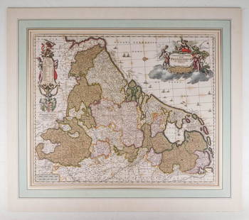
Sold2020Visscher, Claes .Germaniæ Inferioris XVIIVisscher, Claes .Germanie Inferioris XVII Provinciarum. Fine hand colored engraved double-page map. 18-1/2 x 22-1/2 inches plus margins, blank on verso, neatly matted; some browning, generally sound.See Sold Price
Sold2021Boston35. Boston.Report of the Joint Committee on Public Lands in relation to the Public Garden. Large folding map by Ezra Lincoln. 52 pages. 8vo, printed wrappers; moderate wear. Boston, 1850 [75/100]CitySee Sold Price
Sold2023MAP, Eastern US, BowenColonial Eastern United States. Emanuel Bowen, A Map of the British American Plantations, Extending from Boston in New England to Georgia; Including All the Back Settlements in the Respective ProvinceSee Sold Price
Sold2017New England Business Directory, 1875.Heading: (New England) Author: Title: New England Business Directory. 1875. Place Published: Boston Publisher:Sampson, Davenport, & Co. Date Published: 1875 Description: 15See Sold Price
Sold2019Group of Five (5) 19th Century MapsIncluding England Scotland and Ireland Britain or the United Kingdom published by Cummings & Hillard No. 1 Cornhill Boston, Newfoundland Nova Scotia and New Brunswick map, French map of North America,See Sold Price
Sold2021Two Early Maps of the Texas RepublicTwo Early Maps of the Texas Republic each engraved with hand-coloring, the first by T. G. Bradford, engraved by G. W. Boynton, published Boston, 1838; the second by C. S. Williams, from A New UniversaSee Sold Price
Sold20201869 Mitchell Map of Atlantic States from MassachusettsTitle/Content of Map: 1869 Mitchell Map of Atlantic States from Massachusetts to Delaware [verso] Map of New York, New Jersey, Pennsylvania & Delaware -- IX Massachusetts, Rhode Island and ConnecticutSee Sold Price
2 days LeftDoyle New YorkWith attractive heliotype plates capturing the design of turtle shellsUS$100(1 bid)
6 days LeftTremont AuctionsJohn Speed and Francis Lamb "Map of New England and New York", ca. 1676. Hand colored engraved mapUS$900(3 bids)
2 days LeftDoyle New YorkA highly detailed map of New England after the Jansson-Visscher seriesUS$200(1 bid)
3 days LeftJasper52New Guinea & Papuan Archipelago. Solomon & Bismarck islands. THE TIMES 1900 mapUS$20


![1853 Boynton Map of Boston [verso] Map of New England: Title: 1853 Boynton Map of Boston [verso] Map of New England -- New Map of Boston, Comprising the Whole City, with the New Boundaries of the Wards… [verso] Map of New England Exhibiting the Rail Roa](https://p1.liveauctioneers.com/5584/190355/95871630_1_x.jpg?height=310&quality=70&version=1609884614)
![1853 Boynton Map of Boston [verso] Map of New England First Image](https://p1.liveauctioneers.com/5584/178208/89700256_1_x.jpg?height=300&quality=1&version=1599603893&width=300)
![1853 Boynton Map of Boston [verso] Map of New England First Image](https://p1.liveauctioneers.com/5584/178208/89700256_1_x.jpg?height=300&quality=95&version=1599603893&width=300)


![Newspapers: 157. Newspapers. Group of newspapers, as listed below. First with map of Long Island. Folio, loose as issued; varying wear, some soiling, margin tears, etc., SOLD-AS-IS. Vp, vd [200/300]Boston Cultiva](https://p1.liveauctioneers.com/1352/254382/132649399_1_x.jpg?height=310&quality=70&version=1658086673)
![Boston: 35. Boston.Report of the Joint Committee on Public Lands in relation to the Public Garden. Large folding map by Ezra Lincoln. 52 pages. 8vo, printed wrappers; moderate wear. Boston, 1850 [75/100]City](https://p1.liveauctioneers.com/1352/196201/99068135_1_x.jpg?height=310&quality=70&version=1615028908)


![1869 Mitchell Map of Atlantic States from Massachusetts: Title/Content of Map: 1869 Mitchell Map of Atlantic States from Massachusetts to Delaware [verso] Map of New York, New Jersey, Pennsylvania & Delaware -- IX Massachusetts, Rhode Island and Connecticut](https://p1.liveauctioneers.com/5584/178208/89700132_1_x.jpg?height=310&quality=70&version=1599603893)


![[MAP - TOURS] (1 of 1)](https://p1.liveauctioneers.com/292/326828/175962850_1_x.jpg?height=282&quality=70&version=1713473479)


