Sold20231861. Lower and Upper Canada. By Johnson and Browning>Title: 1861. Lower and Upper Canada. By Johnson and Browning Date/Period: 1861 Materials: Steel engraved Size: 26 x 18” 1861, by Johnson and Browning. From ‘New Illustrated Family Atlas, with DesSee Sold Price
20231861 Map of Lower and Upper Canada. By Johnson and BrowningTitle: 1861 Map of Lower and Upper Canada. By Johnson and Browning Date/Period: 1861 Materials: Steel engravedSize: 26 x 18” 1861, by Johnson and Browning. From ‘New Illustrated Family AtlSee Sold Price
Sold20201861 Upper Canada. By Johnson.Title: 1861 Upper Canada. By Johnson. Date/Period: 1861 Materials: Steel engraved. Size: 15 3/4 x 12 “ 1861. By A. J. Johnson & J. H Colton. From "Johnson's New Illustrated Family Atlas' published iSee Sold Price
Sold20201861 Upper Canada. By JohnsonTitle: 1861 Upper Canada. By Johnson Date/Period: 1861 Materials: Steel engraved. Size: 15 3/4 x 12 “ 1861. By A. J. Johnson & J. H Colton. From "Johnson's New Illustrated Family Atlas' published inSee Sold Price
Sold20201861 Lower Canada with insert of Montreal. By JohnsonTitle: 1861 Lower Canada with insert of Montreal. By Johnson Date/Period: 1861 Materials: Steel engraved. Size: 16 3/4 x 12 “ 1861. By A. J. Johnson & J. H Colton. From "Johnson's New Illustrated FaSee Sold Price
Sold2019Five Maps: consisting of two copies of Johnson & Ward,Five Maps: consisting of two copies of Johnson & Ward, "Lower and Upper Canada," 1860-1863, hand colored, H.- 26 1/2 in., W.- 18 1/8 in.; together with two copies of Johnson & Ward, "Lower Canada & NeSee Sold Price
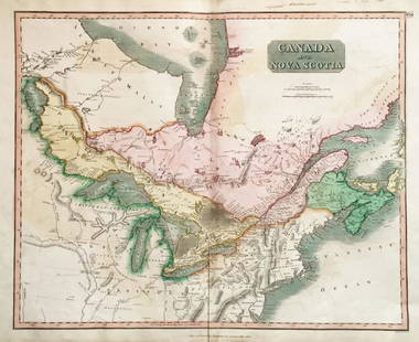
Sold2018Thomson: Upper & Lower Canada, Nova ScotiaMap: Canada and Nova Scotia Cartographer: Thomson Place/Date: Edinburgh / 1814/1817 Size: 23 3/4" x 19 1/8" Condition: wash color; light browning along centerfold and in margins; some staining in uppeSee Sold Price
Sold2019Upper and lower CanadaTitle/Content of Map: Upper and lower Canada Date 1863 Cartographer: By Johnson & Ward. From, Johnson’s New Illustrated Family Atlas Size: 18x26” Provenance: New York. Hand colored. Text on verso.See Sold Price
Sold2019Two Maps by A. J. Johnson, consisting of " NorthTwo Maps by A. J. Johnson, consisting of " North America," 1861, hand colored, h.- 27 in., W.- 18 1/8 in.; together with "Canada, East or Lower Canada and New Brunswick," 1863-1869, H.- 11 7/8 in., W.See Sold Price
Sold2023JOHNSON, SAMUEL. LIVES OF THE POETS. 4 VOLS. 1801Johnson, Samuel. 4 vols. THE LIVES OF THE MOST EMINENT ENGLISH POETS. London: H. Baldwin, J. Johnson, G. G. and J. Robinson, etc., 1801. 4 vols, 8vo. Contemporary full calf. Matching upper and lower wSee Sold Price
Sold2021JOHNSON & COLTON NEW ILLUSTRATED FAMILY ATLAS 1861Johnson's New Illustrated steel plate family atlas with descriptions. Compiled Drawn and Engraved under the supervision of J.H. Colton and A. J. Johnson 1861 Johnson and Browning New YorkSee Sold Price
Sold2024Scarce Georgia-Alabama Civil War-era RR map by Johnson & Browning, 1861Johnson’s Georgia and Alabama from the scarce 1861 edition of Johnson’s Family Atlas published shortly after the outbreak of the war in 1861 by Johnson & Browning. Shows network of railroaSee Sold Price
Sold2017Cary: Antique Map of Upper & Lower Canada, 1807Map: A New Map of Upper & Lower Canada Cartographer: John Cary Place & Date: London / 1807 Size: 20 1/4" x 18" Condition: original color; light overall age toning; a repaired nick in the edge of the uSee Sold Price
Sold2023Texas. 1861 by Johnson and BrowningTitle: Texas. 1861 by Johnson and Browning Date/Period: 1861 Materials: Steel engraved Size: 26 x 18” With inserts of the northern region, Galveston Bay, and a lake. 1861, by Johnson and BrowninSee Sold Price
Sold2022N. America, Johnson & Browning 1861Impressive early Johnson map of North America with huge top and bottom margins. This map’s most significant change over earlier Johnson & Browning versions is the inclusion of Colorado territorySee Sold Price
Sold20191798 Hand Colored Map of Upper & Lower Canada1798 hand colored map of upper and lower Canada, published in London by J. Storkdale of Piccadilly. Rough edges and some foxing. Unframed. Measures approximately 8-1/4" in height by 10-1/4" in width.See Sold Price
Sold2021United States With Upper & Lower CanadaPublication Date: 1850Title: United States With Upper & Lower Canada Cartographer: CRUCHLEY, G.F. Publisher: CRUCHLEY, G.F. Height: 17.5 Width: 13.8 Shows U.S. just past the first tier of states w. ofSee Sold Price
Sold2019Canada West or Upper Canada. Lower Ontario. AntiqueTITLE OF MAP (NOT PRINTED ON THE PAGE):'Canada West or Upper Canada' DATE PRINTED: 1863 IMAGE SIZE: Approx 34.5 x 42.0cm, 13.5 x 16.5 inches (Large) TYPE: Antique engraved hand coloured atlas map CONDSee Sold Price
Sold2018Upper & Lower Canada.Reserve Reduced! Title: Upper & Lower Canada. Publication Date: 1835 Cartographer: BRADFORD, T.G. Publisher: AMERICAN STATIONERS COMPANY Size: 7.5 X 9.75 Map showing districts separately colored, townSee Sold Price
Sold2023Maryland and Delaware with multiple buildings shown. 1861 By Johnson and Browning>Title: Maryland and Delaware with multiple buildings shown. 1861 By Johnson and Browning Date/Period: 1861 Materials: Steel engraved Size: 18x13” With views of the capital, patent office, treasury,See Sold Price
Sold2017Colton: Antique Map of West & Upper Canada, 1861Map: Canada West/Upper Canada Date Printed: 1861 Cartographer: J.H. Colton Material/Medium: Paper Size: 17 1/2" x 14" Hand colored, steel engraved. Printed in New York. From Colton's 'General Atlas'.See Sold Price
Sold2017Colton: Antique Map of East / Lower Canada, 1861Title/Content of Map: Canada east or lower Canada Date Printed: 1861 Cartographer: J. H. Colton Material/Medium: Paper Size: 17 1/2" x 13" Condition: Excellent Hand colored, steel engraved. From 'ColtSee Sold Price
Sold2017Colton: Antique Map of West or Upper Canada, 1861Title/Content of Map: Colton's Canada West or Upper Canada Date Printed: 1861 Cartographer: Colton Material/Medium: Paper Size: 17" x 14" Hand colored steel engraved. Published in New York. Joseph HutSee Sold Price
Sold2022(UNITED STATES - REPUBLIC OF TEXAS.) James Wyld. Map of the United States and the Provinces of Upper(UNITED STATES - REPUBLIC OF TEXAS.) James Wyld. Map of the United States and the Provinces of Upper & Lower Canada, New Brunswick, and Nova Scotia, Compiled from the Latest Surveys and Other AuthentiSee Sold Price
Jun 14DuMouchellesAntique International Small Coins, Feat. French, Canadian, British & Spanish, 1828-1907US$50
13 hrs LeftJasper52Walt Whitman Leaves Of Grass Doubleday Doran 1940 Ill. Lewis C.Daniel VGood HCUS$140
Jun 06Freeman's | HindmanWILDE, Oscar (1854-1900). The Importance of Being Earnest. A Trivial Comedy for Serious People.US$500
Jun 06Freeman's | HindmanDICKENS, Charles (1812-1870). [Great Expectations from All the Year Round]. All the Year Round.US$1,000
2 days LeftForum AuctionsMineralogy.- Paracelsus (Theophrastus Bombastus) Ettliche tractatus. I. Von natürlichen dingen. II.£1,500
2 days LeftJasper52Artist Unidentified Manner of Charles Bragg Modernst Kingly Man w/Flowered CloakUS$120
2 days LeftRichard L. Edwards Auctioneering1989 Upper Deck Randy Johnson RC #25 & 1989 Donruss Randy Johnson RC #42US$1(1 bid)


![Milne (A.A.) [The Christopher Robin books], first editions, 1924-28. (1 of 1)](https://p1.liveauctioneers.com/5458/329231/177515073_1_x.jpg?height=282&quality=70&version=1715269091)


![DICKENS, Charles (1812-1870). [Great Expectations from All the Year Round]. All the Year Round. (1 of 2)](https://p1.liveauctioneers.com/197/329405/177652406_1_x.jpg?height=282&quality=70&version=1715364568)


