Sold2019Canada West or Upper Canada. Lower Ontario. AntiqueTITLE OF MAP (NOT PRINTED ON THE PAGE):'Canada West or Upper Canada' DATE PRINTED: 1863 IMAGE SIZE: Approx 34.5 x 42.0cm, 13.5 x 16.5 inches (Large) TYPE: Antique engraved hand coloured atlas map CONDSee Sold Price
Sold2022ANTIQUE CANADIANA PINE FLAT TO THE WALLCanadian cupboard with upper shelving over two pull drawers and two lower doors. Ontario, Canada, 19th C. H. 76 1/4" W. 40 1/4" D. 20"See Sold Price
Sold2019Meyer: Upper Canada (Ontario) / Lower Canada (Quebec)Map Title: Ober (Upper) Canada 1849 / Unter (Lower) Canada 1849 Cartographer: Bibliographischen Instituts. Place/Date: Hildburghausen / 1849/1857 Size: 14 5/8" x 11 3/4" Condition: original outline coSee Sold Price
Sold20191855 Colton Map of Ontario -- Canada West or UpperTitle/Content of Map: 1855 Colton Map of Ontario -- Canada West or Upper Canada Date: 1855, New York Cartographer: J Colton Size: 11.8 X 14.7 in. This is a very nice map of today's Ontario. Plenty ofSee Sold Price
Sold2017Colton: Antique Map of West & Upper Canada, 1861Map: Canada West/Upper Canada Date Printed: 1861 Cartographer: J.H. Colton Material/Medium: Paper Size: 17 1/2" x 14" Hand colored, steel engraved. Printed in New York. From Colton's 'General Atlas'.See Sold Price
Sold2017Cary: Antique Map of Upper & Lower Canada, 1807Map: A New Map of Upper & Lower Canada Cartographer: John Cary Place & Date: London / 1807 Size: 20 1/4" x 18" Condition: original color; light overall age toning; a repaired nick in the edge of the uSee Sold Price
Sold2017Colton: Antique Map of West or Upper Canada, 1861Title/Content of Map: Colton's Canada West or Upper Canada Date Printed: 1861 Cartographer: Colton Material/Medium: Paper Size: 17" x 14" Hand colored steel engraved. Published in New York. Joseph HutSee Sold Price
Sold2018Ettling: Antique Map of Upper Canada, 1863TITLE/CONTENT OF MAP: 'Upper Canada' Lakes Huron, Erie & ONTARIO. Counties. Railways. DATE PRINTED: 1863 IMAGE SIZE: Approx 32.0 x 44.5cm, 12.5 x 17.5 inches (Large) TYPE: Antique map with original ouSee Sold Price
Sold2022Antique Map - Map of North America - Canada - Toronto - Montreal - William HugheAn interesting mid 19th century map of Upper and Lower Canada - with an inset of New Brunswick and Nova Scotia - which appeared in Barclay's Universal English Dictionary (London: George Virtue, 1840s)See Sold Price
Sold2018Tallis/Rapkin: Antique Map of West Canada, 1849TITLE/CONTENT OF MAP: 'West Canada' The map shows the eastern part of modern Ontario, divided into districts/counties. Part of the map is shown as "Indian territory", with "Indian traders" marked. VigSee Sold Price
Sold202319thc Colton Map of Canada West, Upper Canada19th Century dated 1855 in the plate; published 1857, from Colton's General Atlas. J.H. Colton Map of Canada West or Upper Canada. Detailed with identification of provinces and or regions, cities, towSee Sold Price
Sold20231859 Canada West or Upper Canada. By Colton>Title: 1859 Canada West or Upper Canada. By Colton Date/Period: 1859 Materials: Hand colored steering engraved Size: 17 1/2 x 14 1/2” Canada West or Upper Canada with Niagara area insert. 1859. BySee Sold Price
Sold2017J. H. Colton Canada West (or Upper Canada) MapMap of Canada West (or Upper Canada) J. H. Colton 1857, 17.25 x 14 in Please note that this lot has a confidential reserve. When you leave a bid in advance of the auction, submit your maximum. Jasper5See Sold Price
Sold2018GREAT LAKES. Upper Canada districts <1849 Lake HuronTITLE/CONTENT OF MAP: 'NORTH AMERICA, SHEET III., Upper Canada and New Brunswick with parts of New York, Pennsylvania and Michigan' The map shows the historic districts of Upper Canada (Ontario) as thSee Sold Price
Sold2020WEST CANADA'. Southern Ontario. Shows'Indian territory'TITLE/CONTENT OF MAP: 'West Canada' The map shows the eastern part of modern Ontario, divided into districts/counties. Part of the map is shown as "Indian territory", with "Indian traders" marked. VigSee Sold Price
Sold2019WEST CANADA. Southern Ontario. Shows 'Indian territory'TITLE/CONTENT OF MAP: 'West Canada' The map shows the eastern part of modern Ontario, divided into districts/counties. Part of the map is shown as "Indian territory", with "Indian traders" marked. VigSee Sold Price
Sold2019WEST CANADA'. Southern Ontario. Shows'Indian territory'TITLE/CONTENT OF MAP: 'West Canada' The map shows the eastern part of modern Ontario, divided into districts/counties. Part of the map is shown as "Indian territory", with "Indian traders" marked. VigSee Sold Price
Sold2023[UPPER CANADA] THE LOWER CANADA WATCHMAN. 1829THE LOWER CANADA WATCHMAN: Kingston: James Macfarlane, 1829. 12mo. Brown paper boards backed in grey cloth. Title in paper label on spine. All edges speckled brown. Generally very good condition: boarSee Sold Price
Sold2021Three Volumes of British America, 1839"A Historical and Descriptive Account of British America, Comprehending Canada Upper and Lower, Novia Scotia...". Oliver and Boyd, Edinburgh 1839. First edition. In three volumes with engraved title pSee Sold Price
Sold20191798 Hand Colored Map of Upper & Lower Canada1798 hand colored map of upper and lower Canada, published in London by J. Storkdale of Piccadilly. Rough edges and some foxing. Unframed. Measures approximately 8-1/4" in height by 10-1/4" in width.See Sold Price
Sold2021United States With Upper & Lower CanadaPublication Date: 1850Title: United States With Upper & Lower Canada Cartographer: CRUCHLEY, G.F. Publisher: CRUCHLEY, G.F. Height: 17.5 Width: 13.8 Shows U.S. just past the first tier of states w. ofSee Sold Price
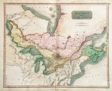
Sold2018Thomson: Upper & Lower Canada, Nova ScotiaMap: Canada and Nova Scotia Cartographer: Thomson Place/Date: Edinburgh / 1814/1817 Size: 23 3/4" x 19 1/8" Condition: wash color; light browning along centerfold and in margins; some staining in uppeSee Sold Price
Sold2018Upper & Lower Canada.Reserve Reduced! Title: Upper & Lower Canada. Publication Date: 1835 Cartographer: BRADFORD, T.G. Publisher: AMERICAN STATIONERS COMPANY Size: 7.5 X 9.75 Map showing districts separately colored, townSee Sold Price
Sold20231861. Lower and Upper Canada. By Johnson and Browning>Title: 1861. Lower and Upper Canada. By Johnson and Browning Date/Period: 1861 Materials: Steel engraved Size: 26 x 18” 1861, by Johnson and Browning. From ‘New Illustrated Family Atlas, with DesSee Sold Price
May 25Aurora Antique Auction House LtdInlaid relief Buddha built-in Buddha said the Old city metaphor Sutra upper and lower volumes ofUS$1,500
2 days LeftNeely AuctionRomero Britto Sunfest 2004 poster from the West Palm Beach, FL event. Signed Romero Britto lowerUS$100
5 days LeftThe Benefit Shop Foundation Inc.Mid Century & Vintage Postcards Germany, Paris +US$5(3 bids)
Jun 15Bazaar of PersiaCanada Revenue Collection - Ontario - Law - 1929/40 Stamps - van Dam OL84 - $1-5 - F/VF UsedUS$30


![[UPPER CANADA] THE LOWER CANADA WATCHMAN. 1829: THE LOWER CANADA WATCHMAN: Kingston: James Macfarlane, 1829. 12mo. Brown paper boards backed in grey cloth. Title in paper label on spine. All edges speckled brown. Generally very good condition: boar](https://p1.liveauctioneers.com/8124/283183/149424766_1_x.jpg?height=310&quality=70&version=1679790999)