Sold2017Cary: Antique Map of Upper & Lower Canada, 1807Map: A New Map of Upper & Lower Canada Cartographer: John Cary Place & Date: London / 1807 Size: 20 1/4" x 18" Condition: original color; light overall age toning; a repaired nick in the edge of the uSee Sold Price
Sold2022Antique Map - Map of North America - Canada - Toronto - Montreal - William HugheAn interesting mid 19th century map of Upper and Lower Canada - with an inset of New Brunswick and Nova Scotia - which appeared in Barclay's Universal English Dictionary (London: George Virtue, 1840s)See Sold Price
Sold2019Canada West or Upper Canada. Lower Ontario. AntiqueTITLE OF MAP (NOT PRINTED ON THE PAGE):'Canada West or Upper Canada' DATE PRINTED: 1863 IMAGE SIZE: Approx 34.5 x 42.0cm, 13.5 x 16.5 inches (Large) TYPE: Antique engraved hand coloured atlas map CONDSee Sold Price
Sold20191798 Hand Colored Map of Upper & Lower Canada1798 hand colored map of upper and lower Canada, published in London by J. Storkdale of Piccadilly. Rough edges and some foxing. Unframed. Measures approximately 8-1/4" in height by 10-1/4" in width.See Sold Price
Sold2018Ettling: Antique Map of Upper Canada, 1863TITLE/CONTENT OF MAP: 'Upper Canada' Lakes Huron, Erie & ONTARIO. Counties. Railways. DATE PRINTED: 1863 IMAGE SIZE: Approx 32.0 x 44.5cm, 12.5 x 17.5 inches (Large) TYPE: Antique map with original ouSee Sold Price
Sold2018Colton: Antique Map of Upper Canada, 1859Title/Content of Map: Upper Canada by Colton Date Printed: 1859 Cartographer: H.J. Colton Material/Medium: Paper Size: 17 1/2" x 15" Hand colored, engraved Map. Published in New York in Colton's 'GeneSee Sold Price
Sold2017Bradford: Antique Map of Upper Canada, 1838Map: Upper Canada Date Printed: 1838/1841 Cartographer: Thomas G. Bradford Material/Medium: Paper Size: 16 1/2" x 13 1/2" Hand colored. A General Atlas of the World, with a seperate map of each of theSee Sold Price
Sold2017Tanner: Antique Map of Upper Canada, 1843Title/Content of Map: Upper Canada by Tanner Date Printed: 1843 Cartographer: based on the work of H.C. Tanner Material/Medium: Paper Size: 17" x 14" Hand colored engraved Map. From the first editionSee Sold Price
Sold2018Colton: Antique Map of Lower Canada, 1859Title/Content of Map: Lower Canada by Colton Date Printed: 1859 Cartographer: H.J. Colton Material/Medium: Paper Size: 17 1/2" x 15" Hand colored, engraved Map. Published in New York in Colton's 'GeneSee Sold Price
Sold2017Bradford: Antique Map of Lower Canada, 1838Title/Content of Map: Lower Canada and New Brunswick Date Printed: 1838/1841 Cartographer: Thomas G. Bradford Material/Medium: Paper Size: 16 1/2" x 13 1/2" Hand colored. A General Atlas of the WorldSee Sold Price
Sold2016Framed and matted map of Upper and Lower Canada datedFramed and matted map of Upper and Lower Canada dated 1798, published in 1798 by J. Stockdale. Site-7.25"h.x9.5"w.See Sold Price
Sold2017Colton: Antique Map of West & Upper Canada, 1861Map: Canada West/Upper Canada Date Printed: 1861 Cartographer: J.H. Colton Material/Medium: Paper Size: 17 1/2" x 14" Hand colored, steel engraved. Printed in New York. From Colton's 'General Atlas'.See Sold Price
Sold2017Colton: Antique Map of East / Lower Canada, 1861Title/Content of Map: Canada east or lower Canada Date Printed: 1861 Cartographer: J. H. Colton Material/Medium: Paper Size: 17 1/2" x 13" Condition: Excellent Hand colored, steel engraved. From 'ColtSee Sold Price
Sold2016Geographical, Statistical & Historical Map Canada, 1823Map: Geographical, Statistical and Historical Map of Upper and Lower Canada, and the other British Possessions in North America Cartographer: F. Lucas Publishing: Philadelphia / Baltimore, 1823 Size:See Sold Price
Sold2017Colton: Antique Map of West or Upper Canada, 1861Title/Content of Map: Colton's Canada West or Upper Canada Date Printed: 1861 Cartographer: Colton Material/Medium: Paper Size: 17" x 14" Hand colored steel engraved. Published in New York. Joseph HutSee Sold Price
Sold2019Meyer: Upper Canada (Ontario) / Lower Canada (Quebec)Map Title: Ober (Upper) Canada 1849 / Unter (Lower) Canada 1849 Cartographer: Bibliographischen Instituts. Place/Date: Hildburghausen / 1849/1857 Size: 14 5/8" x 11 3/4" Condition: original outline coSee Sold Price
Sold2022(UNITED STATES - REPUBLIC OF TEXAS.) James Wyld. Map of the United States and the Provinces of Upper(UNITED STATES - REPUBLIC OF TEXAS.) James Wyld. Map of the United States and the Provinces of Upper & Lower Canada, New Brunswick, and Nova Scotia, Compiled from the Latest Surveys and Other AuthentiSee Sold Price
Sold2017Cary: Antique Map of North America, 1806Map: A New Map of North America Cartographer: John Cary Place & Date: London / 1806 Size: 20 3/8" x 18" Condition: original color; overall age toning and some spotting and offsetting; browning on uppeSee Sold Price
Sold2018Cary: Antique Map of the Western Hemisphere, 1806Map: A New Map of America Cartographer: John Cary Place & Date: London / 1806 Size: 20 5/8" x 18 1/4" Condition: original color; light overall age toning; browning on upper margin around centerfold ThSee Sold Price
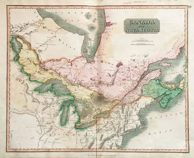
Sold2018Thomson: Upper & Lower Canada, Nova ScotiaMap: Canada and Nova Scotia Cartographer: Thomson Place/Date: Edinburgh / 1814/1817 Size: 23 3/4" x 19 1/8" Condition: wash color; light browning along centerfold and in margins; some staining in uppeSee Sold Price
Sold2018Upper & Lower Canada.Reserve Reduced! Title: Upper & Lower Canada. Publication Date: 1835 Cartographer: BRADFORD, T.G. Publisher: AMERICAN STATIONERS COMPANY Size: 7.5 X 9.75 Map showing districts separately colored, townSee Sold Price
Sold2019Lower Canada, New Brunswick, Nova Scotia' Quebec &TITLE/CONTENT OF MAP: 'Lower Canada, New Brunswick, Nova Scotia &c.; Inset map of Newfoundland' DATE PRINTED: 1862 IMAGE SIZE: Approx 31.0 x 45.0cm, 12.25 x 17.75 inches (Large) TYPE: Antique map withSee Sold Price
20231861 Map of Lower and Upper Canada. By Johnson and BrowningTitle: 1861 Map of Lower and Upper Canada. By Johnson and Browning Date/Period: 1861 Materials: Steel engravedSize: 26 x 18” 1861, by Johnson and Browning. From ‘New Illustrated Family AtlSee Sold Price
Sold2020[CIVIL WAR] Cruchley, G. 1 map[Civil War]. Cruchley, G. F. UNITED STATES WITH UPPER AND LOWER CANADA. London, [c.1860s]. Engraved map, hand coloured. 44cm x 35.3cm (17.25" x 14") black line 46.8cm x 37cm (18.5" x 14.5") sheet A faSee Sold Price
4 days LeftAurora Antique Auction House LtdInlaid relief Buddha built-in Buddha said the Old city metaphor Sutra upper and lower volumes ofUS$1,500
7 days LeftJasper52Early 19th Century Antique George III Silver Gilt Cup & Cover London 1807 Peter CarterUS$4,600
7 days LeftJasper521720 antique MAP of LOWER SAXONY GERMANY 18th CENT. Circulus Saxoniae inferiorisUS$75
6 days LeftA.H. Wilkens Auctions & AppraisalsIGNACE FRANCOIS RANVOYZE 18th C SILVER TUMBLER CUPCA$600
Jun 07Freeman's | HindmanCUNARD, Nancy, editor. Negro Anthology. 1934. FIRST EDITION. ASSOCIATION COPY WITH NOEL SULLIVANUS$2,000
7 days LeftJasper521822 MAP of CANADA & BRITISH POSESSIONS in NORTH AMERICA GEOGRAPHICAL antiqueUS$75


![[CIVIL WAR] Cruchley, G. 1 map: [Civil War]. Cruchley, G. F. UNITED STATES WITH UPPER AND LOWER CANADA. London, [c.1860s]. Engraved map, hand coloured. 44cm x 35.3cm (17.25" x 14") black line 46.8cm x 37cm (18.5" x 14.5") sheet A fa](https://p1.liveauctioneers.com/1124/187577/94368859_1_x.jpg?height=310&quality=70&version=1607095126)


