Sold2022(AFRICA.) Two hand-colored double-page engraved eighteenth-century maps of the continent.(AFRICA.) Two hand-colored double-page engraved eighteenth-century maps of the continent. Nuremberg, 1715-1730s - Homann Heirs. Africa Secundum Legitimas Projectionis Stereographicae. 20¾x24¼See Sold Price
Sold2024Johann B. Homann- Virginia, Marylandia et CarolinaJohann Baptist Homann (German, 1664-1724). "Virginia, Marylandia et Carolina in America septentrionali Britannorum Industria Exclutae," Mid-Eighteenth Century. Double page hand-colored engraved map, pSee Sold Price
Sold2020SPEED, JOHN. Caermarden; and Breknoke.SPEED, JOHN. Caermarden; and Breknoke. Together two hand-colored double-page engraved county maps with town insets. Approximately 16x21 inches each sheet size, ample margins, English text on verso; vaSee Sold Price
Sold2022(ASIA.) Jean Janvier. l'Asie Divisee en ses Princepaux Etats.(ASIA.) Jean Janvier. l'Asie Divisee en ses Princepaux Etats. Large hand-colored double-page engraved map of the Asian continent, Indonesia, and a remarkably distorted island(?) of New Guinea. 21½See Sold Price
Sold2017Two hand colored engraved double page large folio mapsTwo hand colored engraved double page large folio maps including The United States of America and Map of New York and the Adjacent Cities. 16 1/2" x 27" and 17 1/2" x 27" Provenance: Property from CSee Sold Price
Sold2020Antique Map (18th Century)DOMINIUM VENETUM, 1729, hand-colored double page atlas engraving, engraved by G. Mattheus Seutter Jr., image 19 ½ x 22 ¾”, sheet 21 x 23 ¾”.See Sold Price
Sold2020Antique Map (18th Century)IMPERII MAGNI MOGOLIS SIVE INDICI PADSCHACH, hand-colored double-page atlas engraving, engraved by Albrecht Carl Seutter, sheet 19 ½ x 22 ½”.See Sold Price
Sold2018GEORG BRAUN & FRANS HOGENBERG HAND COLORED MAPGEORG BRAUN & FRANS HOGENBERG HAND COLORED DOUBLE-PAGE ENGRAVED MAP, H 13 1/4", W 19", "LUTETIA, VULGARI NOMINE PARIS":DEPICTING 16TH CENTURY PARIS, WITH A DECORATIVE TITLE-CARTOUCHE FEATURING COAT OFSee Sold Price
Sold2022(AFRICA.) Abraham Ortelius. Two double-page engraved maps of northern Africa in original hand-color.(AFRICA.) Abraham Ortelius. Two double-page engraved maps of northern Africa in original hand-color. Antwerp, 1603 - Fessae, et Marocchi Regna Africae Celeberr. (Canary Islands, Morocco, Straits of GiSee Sold Price
Sold2021WEST AFRICA; ABYSSINIA: SUDAN, ETHIOPIA,AND ERITREA. ABRAHAM ORTELIUS (1527-1598)Presbiteri Iohannis, Sive, Abissinorum Imperii Descriptio. Antwerp: Ortelius, c. 1600. Double page copper-plate engraved map on laid paper, hand-colored, textSee Sold Price
Sold2022(CHINA.) Two small format seventeenth-century double-page engraved maps of China and Korea.(CHINA.) Two small format seventeenth-century double-page engraved maps of China and Korea. 14½x9½ inches each sheet size, wide margins; original hand-color in outline; one minor edge repairSee Sold Price
Sold2021"Terra FIrma and Caribbe Islands", Emanuel Bowen"A New and Accurate Map of the Terra Firma and the Caribbe Islands", an 18th century map by Emanuel Bowen (1693-1767). An engraved and hand colored map in two pages with central fold crease, framed. 1See Sold Price
Sold2022SPEED, JOHN. The Kingdome of Persia.SPEED, JOHN. The Kingdome of Persia. Hand-colored double-page engraved map of modern-day Iran, Pakistan, and Afghanistan with carte-a-figures and city plan border panels. 16½x21¼ inches sheeSee Sold Price
Sold2020SPEED, JOHN. Bohemia.SPEED, JOHN. Bohemia. Hand-colored double-page engraved map of the Czech Republic with carte-a-figures and city plan border panels. 16¼x20½ inches sheet size, margins shaved to the neatline,See Sold Price
Sold2022(ITALY.) Gerard Mercator. Italia.(ITALY.) Gerard Mercator. Italia. Hand-colored double-page engraved map of Italy. 15½x19¼ inches sheet size, ample margins, French text on verso; center fold reinforced on verso, Duisberg, 1See Sold Price
Sold2020ORTELIUS, ABRAHAM. Hispaniae Novae Sivae Magnae, RecensORTELIUS, ABRAHAM. Hispaniae Novae Sivae Magnae, Recens et Vera Descriptio. Hand-colored double-page engraved map of southwestern Mexico. 17x21½ inches sheet size, wide margins, Latin text on verSee Sold Price
Sold2019ROBERT de VAUGONDY, GILLES Map.ROBERT de VAUGONDY, GILLES: Environs de Paris, Par Le Sr. Robert Geographe Ordinaire Du Roi with Privileged 1753 Hand-colored double-page engraved map of the country surrounding Paris. 20 ¼ x 2See Sold Price
Sold2020BLAEU, WILLEM. Persia Sive Sophorum Regnum.BLAEU, WILLEM. Persia Sive Sophorum Regnum. Hand-colored double-page engraved map of modern-day Afghanistan, Pakistan, Iraq, Iran, and the Persian Gulf region. 15½x21 inches sheet size, top and bSee Sold Price
Sold201517th C. John Speed, Huntington & Ely MapJohn Speed (British, 1552-1629), "Huntington, both Shire and Shire Town with the ancient citie Ely Described," hand colored, double engraved-page map originally created by noted cartographer, John SpeSee Sold Price
Sold2020(CELESTIAL.) Cellarius, Andreas. Typus Aspectuum,(CELESTIAL.) Cellarius, Andreas. Typus Aspectuum, Oppositionum et Coniuntionum Etz in Planetis. Hand-colored double-page engraved celestial chart with a map of the world on a north-polar projection shSee Sold Price
Sold2018Janssonius Joannes Nova Belgica Et Anglia Nova doubleJanssonius Joannes Nova Belgica Et Anglia Nova double page engraved map, hand colored, ss 15 1/2" x 20"See Sold Price
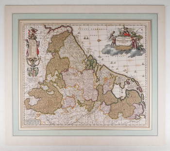
Sold2020Visscher, Claes .Germaniæ Inferioris XVIIVisscher, Claes .Germanie Inferioris XVII Provinciarum. Fine hand colored engraved double-page map. 18-1/2 x 22-1/2 inches plus margins, blank on verso, neatly matted; some browning, generally sound.See Sold Price
Sold2015Cary's New Universal Atlas,Containing Distinct Maps of All the Principal States and Kingdoms, etc., London: Printed for J. Cary, Engraver, 1811, with 56 double-page engraved hand-colored maps on 60 numbered sheets (complete), rSee Sold Price
Sold2016Two Framed Hand-colored Engraved Maps, 19th/20thTwo Framed Hand-colored Engraved Maps, 19th/20th Century, Including a map of Morea olim Peloponnesus by Gerardus Mercator and of Deventer by Johannes Blaeu. Largest framed dimensions: h: 21 1/2 x w: 2See Sold Price
May 30NY Elizabeth 1791 OLD CULINARIAE OLD FASHIONED INTERESTING CULINARY PRACTICES IN OLD ENGLISHUS$50
May 23Potter & Potter Auctions[“SOLDIER IN THE CIVIL WAR”]. Group of 8 Engraved Illustrat...US$50
May 30Forum Auctionsd'Anville (Jean Baptiste Bourguignon) [Untitled Composite Atlas with 102 map sheets], [probably£2,000
May 30NY Elizabeth ANTIQUE MAP-ILLUSTRATED FLORAL ILLUSTRATION 1761 NEW DICTIONARY OF TRADE AND COMMERCE R. ROTHUS$50
Jun 07Freeman's | HindmanWOOLWARD, Florence. The Genus Masdevallia... 1890-1896. FIRST EDITION.US$1,200
Jun 07Freeman's | HindmanHAMILTON, William. -- HANCARVILLE, Pierre-Francois Hugues d'. Collection of Etruscan, Greek andUS$35,000
Jun 08Connoisseur AuctionsRare 19thc Costume Plates, 13th Century Knights Templar, Royalty, ScholarsUS$34


![[MAP]. ORTELIUS, Abraham. Africae Tabula Nova. 1592. (1 of 2)](https://p1.liveauctioneers.com/197/329395/177650533_1_x.jpg?height=282&quality=70&version=1715364962)


![[“SOLDIER IN THE CIVIL WAR”]. Group of 8 Engraved Illustrat... (1 of 4)](https://p1.liveauctioneers.com/928/328184/176813702_1_x.jpg?height=282&quality=70&version=1714496988)
![d'Anville (Jean Baptiste Bourguignon) [Untitled Composite Atlas with 102 map sheets], [probably (1 of 3)](https://p1.liveauctioneers.com/5458/329231/177514974_1_x.jpg?height=282&quality=70&version=1715269091)


![[MAP]. ORTELIUS, Abraham. Romani Imperii Imago. 1592. (1 of 2)](https://p1.liveauctioneers.com/197/329395/177650537_1_x.jpg?height=282&quality=70&version=1715364962)


![[HAND-COLORED AQUATINTS]. [HEATH, William (1795-1840), arti... (1 of 5)](https://p1.liveauctioneers.com/928/328184/176813397_1_x.jpg?height=282&quality=70&version=1714496988)