Sold2022Amér. Sep. Partie des États-Unis #55. North Texas Oklahoma VANDERMAELEN 1827 mapTITLE/CONTENT OF MAP: 'Amér. Sep. - Partie des États-Unis - No. 55' The map shows the course of the Red River through North Texas and southern Oklahoma (which at the time of publication wasSee Sold Price
Sold2022Amér Sep. Partie des États-Unis #57 Georgia South Carolina VANDERMAELEN 1827 mapTITLE/CONTENT OF MAP: 'Amér. Sep. - Partie des États-Unis - No. 57' The map covers Georgia and South Carolina, with adjacent parts of North Carolina and Florida DATE PRINTED: 1827 IMAGE SIZE: ASee Sold Price
Sold2022Amér Sep Haiti Domingue 68 Hispaniola Turks Caicos Bahamas VANDERMAELEN 1827 mapTITLE/CONTENT OF MAP: Amér. Sep. - Haïti ou St. Domingue [Iles Bahama ou Lucayes] - No. 68 The map shows Hispaniola (today Haiti and the Dominican Republic), Turks & Caicos and part of the BSee Sold Price
Sold20211800 Weld Map of Northern United States and Great LakesTitle: 1800 Weld Map of Northern United States and Great Lakes -- Partie des Etats-Unis de L'Amerique Septentrionale Cartographer: I Weld Year / Place: 1800, Paris Map Dimension (in.): 16.1 X !8.2 in.See Sold Price
Sold202118TH CENTURY FRENCH MAP OF SOUTHEASTERN USRigobert Bonne (French, 1727-1794). "Carte De la Partie Sud Des Etats Unis De L'Amerique Septentrionale" -circa 1780, engraving. Provenance: From the Lifetime Collection of Billy S. Arant, Jr., ChattaSee Sold Price
Sold2023"Carte De La Partie Nord, Des Etats Unis, de L'Amérique Septentrionale" by Rigobert Bonne. Paris,“Carte De La Partie Nord, Des Etats Unis, de l'Amerique Septentrionale” by Rigobert Bonne, Ca. 1780s. This post-revolutionary war map features a detailed overview of the mid-Atlantic regioSee Sold Price
Sold2017Tardieu: Antique Map of Northern U.S & Canada, 1798Map: Carte de la Partie Septentrionale des Etats Unis comprenant le Canada Cartographer: Chanlaire & Mentelle / Tardieu Place & Date: Paris / 1798 Size: 16 3/4" x 13" Condition: outline color; mild frSee Sold Price
Sold2016Map of Canada Framed Vintage 40s Print After 1720Map of Canada Framed Vintage 40-s Print After 1720 Guillaume De L'Isle Carte Du Canada Qui Comprend la Partie Septentrionale Des Etats Unis D'Amerique Canada and Great Lakes Map Approximately 21 5/8"See Sold Price
Sold2016Carte des Etats-Unis d'Amerique, du Canada, 1832Map: Carte des Etats-Unis d'Amerique, du Canada, du Nouveau Brunswick et d'une Partie de la Nouvelle Bretagne Cartographer: Pierre M. Lapie Publishing: Paris, 1832 Size: 16 x 20 inches Matted A greatSee Sold Price
Sold20231868 Drioux and Leroy Map of the United States -- Carte Physique et Politique des Etats-Unis, CanadaTitle: 1868 Drioux and Leroy Map of the United States -- Carte Physique et Politique des Etats-Unis, Canada et Partie du Mexique Cartographer: Drioux & Leroy Year / Place: 1868 Map Dimension (in.): 11See Sold Price
Sold2016Carte Genrale Des Etats-Unis Et Du Mexique 1862Map Title: Carte Genrale Des Etats-Unis Et Du Mexique Date: 1862 Publisher: Andriveau-Goujon: Paris Size: 24.3 x 18.25 inches Eastern sheet only. Only east of the Mississippi shown, only Yucatan shownSee Sold Price
Sold2017V Malte-Brun: Carte des Etats-Unis d'Amerique, 1830Map: Carte des Etats-Unis d'Amerique Maker: V Malte-Brun Date: 1830, Brussels/Bruxelles Description: Impactful map of the US, with part of British Columbia shown as US possession. Texas is part of MexSee Sold Price
Sold2018Map, United States, 1784, first map of the nationMap, United States, 1784,"Carte Des Etats-Unis De L'Amerique Suivant le Traite de Paix de 1783. Dediee et Presentee A.S. Excellence M. Benjamin Franklin Ministre Pleinipotentaire des Etats-Unis", theSee Sold Price
Sold2023Carte des Etats-Unis du Mexique & Guatemala. Mexico USA Southwest LAPIE 1829 mapCAPTION PRINTED BELOW PICTURE: Carte des Etats-Unis du Mexique // Carte du Guatemala, ou Provinces-Unies de l'Amérique centrale [The United States of Mexico // Guatemala, or the United ProvincesSee Sold Price
Sold2022(CIVIL WAR.) Jean-Rodolphe Mayer. Nouvelle Carte des Etats-Unis de l'Amerique du Nord… 2de(CIVIL WAR.) Jean-Rodolphe Mayer. Nouvelle Carte des Etats-Unis de l'Amerique du Nord… 2de Edition. Large hand-colored lithographed map of the United States with a keyed reference table numberinSee Sold Price
Sold2023Carte Des Etats-Unis D'ameriquePublication Date: 1836 Title: Carte Des Etats-Unis D'amerique Cartographer: Bouffard, L. Publisher: Bouffard, L. Height: 12 Width: 15 French railroad map of U.S. west to R. Sabine. Does not show FloriSee Sold Price
Sold2016Vandermaelen, Atlas - Amer. Merid.Vandermaelen Philippe, Atlas universel de géographie physique, politique, statistique et minéralogique [...]. Cinquième partie - Amer. Merid. Bruxelles: s.e., 1827. 1 volume (di 6) in-folio oblungoSee Sold Price
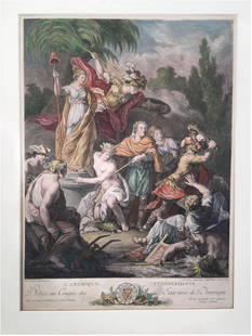
Sold2023Antoine BOREL: Color Engraving by Le VasseurExtremely rare, original 1778 engraving titled "L'Amerique Independante; Dediee au Congres des Etats Unis de l'Amerique" [Independent America; dedicated to the Congress of the United States of AmericaSee Sold Price
Sold2022[CONSTITUTION] DE LA ROCHEFOUCAULD D'ENVILLE, LOUIS ALEXANDRE (Duc de), translator. Constitutions[CONSTITUTION] DE LA ROCHEFOUCAULD D'ENVILLE, LOUIS ALEXANDRE (Duc de), translator. Constitutions des Treize Etats-Unis de L'Amerique. Philadelphia and Paris: [printed for La Rochefoucault and BenjamiSee Sold Price
Sold2024BEN. FRANKLIN CONSTITUTIONS DES TRIEIZE ETATS 1783Constitutions Des Treize Etats-Unis de l'Amerique. Printed 1783 by D. Pierres, Paris. Contains the first printed appearance of the Great Seal of the United States designed by Benjamin Franklin. The FrSee Sold Price
Sold2022Mitchell's Map of the states of Louisiana, Mississippi, & Alabama 1834MITCHELL, Samuel Augustus (1790-1868). Map of the states of Louisiana, Mississippi, & Alabama. Engraved map with original hand color. Philadelphia: S. Augustus Mitchell, 1834. 17 1/2" x 12 1/2" sheet.See Sold Price
Sold2017Buchon: Antique Map of the United States w/ 24 StatesTitle/Content of Map: 'Etats-Unis d'Amérique' This fascinating map shows the United States, which at the date of publication in 1825 consisted of 24 states. Also shown are a number of unincorporatedSee Sold Price
Sold2022J. H. Colton’s Topographical Map of Louisiana, Mississippi and Alabama. & partsTitle: J. H. Coltonâ€â„¢s Topographical Map of Louisiana, Mississippi and Alabama. & parts of Adjoining States. Publisher: Joseph Hutchins Colton Height: 19 Width: 31 Rare Colton large forSee Sold Price
Sold2022Crevecoeur French Edition of Evans Map of Middle ColoniesCREVECOEUR, Michel Guillaume De (1735-1813). Carte Generale des Etats de Virginie, Maryland, Delaware, Pensilvanie, Nouveau-Jersey, New-York, Connecticut et Isle de Rhodes Ainsi que des Lacs Erie, OntSee Sold Price
2 days LeftJasper52Amér. Sep. Partie de l'Amérique Russe #14 Colombia profile VANDERMAELEN 1827 mapUS$55
Jun 12Dan Morphy AuctionsBRUE'S MONUMENTAL WALL MAP OF TEXAS, UPPER CALIFORNIA & MEXICO, C. 1845US$500
Jun 14DuMouchellesRigobert Bonne (French, 1727-1794) Hand Colored Engraving Ca. 18th Century, Les Etats Unis DeUS$50
2 days LeftJasper52Amér Mér Colombie & Brésil 9 Peru Colombia Amazonas Brazil VANDERMAELEN 1827 mapUS$70
1 day LeftJasper521719 Chatelain Map of Russian Empire -- Carte Generale des Etats du Czar Empereur de Moscovie…US$320
1 day LeftJasper521719 Chatelain Map of the Adriatic and Venice Republic -- Carte de Geographie des Differents EtatsUS$190
2 days LeftBonhamsLINE VAUTRIN (1913-1997) Boîte Allez, laissez couler les jours, allégez-les, l'amour e...€1,200(1 bid)
Jun 07Freeman's | HindmanHOMANN, Johann Baptist. Amplissimae Regionis Mississipi Seu Provinciae Ludovicianae. Nuremburg, [caUS$400(1 bid)
Jun 07Freeman's | HindmanBELLIN, Jacques-Nicolas. Carte Reduite de L'Ocean Oriental ou Mer Des Indies. Paris, 1757. SecondUS$150
Jun 14Crescent City Auction GalleryAfter Marie Adrien Persac (French/Louisiana, 1823-1873), "Plantations on the Mississippi River fromUS$325
5 days LeftLink Auction GalleriesDry, Camille, N. Pictorial St. Louis: The Great Metropolis of the Mississippi Valley. AUS$1,500
3 days LeftHAMMER AUKTIONEN, African, Tribal, Oceanic & Asian ArtA Kuba Cut-Pile Embroidery FabricCHF 5(1 bid)


![Amér Sep Haiti Domingue 68 Hispaniola Turks Caicos Bahamas VANDERMAELEN 1827 map: TITLE/CONTENT OF MAP: Amér. Sep. - Haïti ou St. Domingue [Iles Bahama ou Lucayes] - No. 68 The map shows Hispaniola (today Haiti and the Dominican Republic), Turks & Caicos and part of the B](https://p1.liveauctioneers.com/5584/271521/142285193_1_x.jpg?height=310&quality=70&version=1670968215)


![Vandermaelen, Atlas - Amer. Merid.: Vandermaelen Philippe, Atlas universel de géographie physique, politique, statistique et minéralogique [...]. Cinquième partie - Amer. Merid. Bruxelles: s.e., 1827. 1 volume (di 6) in-folio oblungo](https://p1.liveauctioneers.com/1306/86019/44239760_1_x.jpg?height=310&quality=70&version=1457627563)
![[CONSTITUTION] DE LA ROCHEFOUCAULD D'ENVILLE, LOUIS ALEXANDRE (Duc de), translator. Constitutions: [CONSTITUTION] DE LA ROCHEFOUCAULD D'ENVILLE, LOUIS ALEXANDRE (Duc de), translator. Constitutions des Treize Etats-Unis de L'Amerique. Philadelphia and Paris: [printed for La Rochefoucault and Benjami](https://p1.liveauctioneers.com/292/250642/130213472_1_x.jpg?height=310&quality=70&version=1654271664)


