Sold2019Carbu, François - Barques de pêche à l'entrée du portCarbu, François (XX) Barques de pêche à l'entrée du port Description (FR): Huile sur toile, signée en bas à gauche Carbu Description (EN): Oil on canvas, signed on lower left Carbu Dimension (POSee Sold Price
Sold2018Bellin: Antique View Zihuatanejo & Acapulco Harbor 1754Title/Content of Map: Vue de l'Entree de Chequetan ou Seguataneo/Vue de l'Entree du Port d'Acapulco Cartographer: Bellin Place & Date: Leipzig / 1754 Size: 14" x 8 1/8" Condition: b&w; overall age-tonSee Sold Price
Sold2017Dela Haye: Plan de la Baye de l'Acul (Haiti), 1787Map: Plan de la Baye de l'Acul; Baye de Dame-Marie; Le Port François; Plan du Môle St. Nicolas; Baye des Irois Cartographer: Dela Haye / Dépôt de la Marine Place & Date: Paris / 1787 Size: 17 1/2"See Sold Price
Sold2023L Entree Du Port Mahon + La Vue Do Fort S Philippe PrintsEach sight: 7" high x 9" wide. Overall with frame 11-1/4" high x 13-1/4" wide.See Sold Price
Sold2018Cassas: Antique View of Trieste’s Grand Canal, 1802Vue de l'Entrée du Grand Canal de Trieste A superb, beautifully engraved view of the entrance to the Grand Canal of Trieste, showing the waterway filled with vessels large and small, from Joseph LavaSee Sold Price
Sold2022(2) DEVERAUX FRENCH LITHOGRAPHS PORT SCENESIncluding "Entree du Port de Dunkerque" and "Le Port de Brest." Dimensions: (Frame) H 13" x W 16", (Sight) H 6.5" x W 9.5" Condition: Toning to paper. Minor frame wear.See Sold Price
Sold2018Print of the Battle Of DunkirkPrint of the Battle of Dunkirk, War ships at the mouth of the Channel, Entree Du Port De Dunkerque, Val de la Rade, Framed, Matted And under glass, the actual print approx 3 in x 2 1/4 in, the overallSee Sold Price
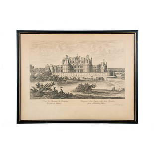
Sold2020VEUE DU CHASTEAU DE CHAMBOR Engraving by IsraelVeue du chasteau de chambor, du coste de l'entree copperplate engraving by Israel Silvestre (French, 1621-1691). Signed and dated by the artist within the lower left bottom of the plate. Published bySee Sold Price
Sold2024Entrée de Norton & Détroit de Bhering. Bering Strait Norton Sound BONNE 1790 mapTITLE/CONTENT OF MAP: [Cook 3e Voyage] Carte de l'entrée de Norton et du Détroit de Bhering, où l'on voit le Cap le plus Oriental de l'Asie et la pointe la plus Occidentale de l'AméSee Sold Price
Sold20221764 Bellin Map of Cap Haitien Bay in Haiti -- Plan du Port du Cap dans l'Isle de St. DomingueTitle: 1764 Bellin Map of Cap Haitien Bay in Haiti -- Plan du Port du Cap dans l'Isle de St. Domingue Cartographer: J Bellin Date/Place: 1764, Paris Dimensions: 9.1 X 14.1 in. Description: This handsoSee Sold Price
Sold2022DEL RIO, JOSE Plan du Port et de la Ville de la Havanne leve en 1798. [Paris:] par Ordre du MinistreDEL RIO, JOSE Plan du Port et de la Ville de la Havanne leve en 1798. [Paris:] par Ordre du Ministre de la Marine et des Colonies, l'An IX de l'Ere Francaise, [circa 1800]. Engraved map with the "DepoSee Sold Price
Sold2017Bellin: Plan Du Port Carenage, 1763Map Title: Plan Du Port Carenage ou Petit Cul De Sac De L’Isle Se Lucie Maker: Jacques Bellin Printed in Paris Date: Circa 1763 Dimensions: 9 x 11.5 inches Jacques-Nicolas Bellin(1703-1772) was a FrSee Sold Price
Sold20231764 Bellin Map of Castries in St. Lucia, Lesser Antilles -- Plan du Port du Carenage ou Petit CulTitle: 1764 Bellin Map of Castries in St. Lucia, Lesser Antilles -- Plan du Port du Carenage ou Petit Cul de Sac de l'Isle Se Lucie Cartographer: J Bellin Year / Place: 1764, Paris Map Dimension (in.)See Sold Price
Sold2019Antique French Lacquer PanelAntique French lacquer panel: “Portrait de L'Ordre Hoquet L'O a Marbre a l'Entree du Roy Houys XIII Dans Sa Ville". [Art: 24 x 57 inches; Frame:28 1/2 x 62 inches]. Warped; repairs.See Sold Price
Sold2022Anna DE WEERT (1867-1950)L’entrée du jardin Aquarelle sur papier, signé en bas à droite 19,4 x 25,6 cmSee Sold Price
Sold2019Desnos, Louis Charles 1765 Map of Paris, France"Pmiere. Flle. de l'Indicateur Fidele du Voyageur Francois" City Plan of Paris, showing routes out of the city to other parts of France. Copper Engraved Map Published 1765, Paris for "Coup d'oeil geneSee Sold Price
Sold2021Bellin, Jacques-Nicolas - Plan du port et ville deBellin, Jacques-Nicolas (1703-1772) Plan du port et ville de Louisbourg dans l'Isle royale (1744) Description: P.N.B. Ing. de la M. 1744. Extract from the Petit atlas maritime published in Paris in 17See Sold Price
Sold20231773 OBSTETRICS 3 volumes ILLUSTRATED antique De L'Homme Et De La Femme[Louis François Luc De]. De L'Homme Et De La Femme Consideres Physiquement Dans L'Etat Du Mariage. Lille; 1773 3 volumes Size 4 by 6 1/2" 272, 277, [3], 240 pp. 14 engraved illustrative plates atSee Sold Price
Sold2018Cassas: Napoleonic Wars Naval Battle, Trieste HarborVue générale de Trieste. De son Port, du Lazareth & des Côtes de l'Istrie, prise du Chemin de Vienne A scarce, beautifully engraved panoramic view of Trieste, its harbor and part of the Istrian coaSee Sold Price
Sold2021French Optical View, NewfoundlandHand colored optical view etching, "Vue Perspective de la Descente des Francois a l'Isle de Terre Neuve du Cote de Saint Jean a l'Occident". Sight 11"h x 15.25"w, frame 17"h x 21"wSee Sold Price
Sold2023Détroit de Magellan. Strait of Magellan. Chile. BONNE 1790 old antique map[Voyage des Capitaines Byron, Vallis et Carteret] Détroit de Magellan avec les Plans des principaux Ports, Bayes &c. de ce Détroit // Havre Swalow ou de l'Hirondelle // Baye du Cap Upright // BaSee Sold Price
Sold20221764 Bellin Map of Castries, St Lucia in Lesser Antilles -- Plan du Port et du Carenage de CariacouaTitle: 1764 Bellin Map of Castries, St Lucia in Lesser Antilles -- Plan du Port et du Carenage de Cariacoua Situe dans la Partie du Sud de l'Isle de St. Vincent Cartographer: J Bellin Date/Place: 1764See Sold Price
Sold20171764 Map of Port At St. Vincent BellinCopper Plate Engraved Map “plan Du Port Et Du Carenage De Cariacoua Situe Dans La Partie Du Sud De L'isle De St. Vincent”, Bellin's "le Petit Atlas Maritime, Ou Recueil De Cartes Et De Plans Des QSee Sold Price
Sold2022Calendar – Astronomy. RIVARD. Abregé de la Sphère.RIVARD, François-Dominique. Abregé de la Sphère, et du Calendrier, à l’usage de ceux qui ne sçavent pas de Géométrie. Paris, Lottin, Desaint et Vaillant, 1743.See Sold Price
Champagne AuctionsCarbu, François - Bretagne - Barques de pêche à l'entrée du portCA$150(4 bids)
May 22Thomaston Place Auction Galleries(4) 18TH C. VUE D'OPTIQUES & (1) 18TH C. HANDCOLORED ENGRAVING, FRAMEDUS$300
10 hrs LeftJasper521777 PERU HISTORY 2 VOLUMES antique Les incas destruction de l'empire du PerouUS$320
2 days LeftPotter & Potter AuctionsMANTELET, Albert (1858 – 1958). Palais de l’Industrie / Exp...US$125
4 days LeftTrillium Antique Prints & Rare BooksKarl Bodmer - Bison-Dance of the Mandan Indians in front of their Medicine Lodge in Mih-TuttaUS$300
4 days LeftTrillium Antique Prints & Rare BooksKarl Bodmer - The Elkhorn Pyramid on the upper Missouri. 21US$300
10 hrs LeftJasper521725 MATHEMATICS FOR ARTILLERY & ENGINEERING antique by B. Belidor ILLUSTRATEDUS$320
BonhamsFrench School (19th Century) Pont de l'Alma, Paris (framed 47.0 x 60.0 x 6.5 cm (18 1/2 x 23 5/...US$150(2 bids)
Jun 11BonhamsSTATUETTE DU FONDATEUR DE L'ORDRE DRIGUNG KAGYU, JIGTEN SUMGON RINCHEN PEL, SUR SON TRÔNE, ...€80,000
10 hrs LeftJasper521804 TRAVELS of Ledyard & Lucas in Africa antique w/ MAPS Voyages de MM. LédyardUS$240
Jun 07Freeman's | Hindman[ERAGNY PRESS]. RONSARD, Pierre de. Abregé de l'Art Poetique François. 1903. LIMITEDUS$100
2 days LeftPotter & Potter AuctionsCONCHON, L. Liqueur du Couvent de Ste. Barbe. 1927. Paris: L...US$350(1 bid)


![Entrée de Norton & Détroit de Bhering. Bering Strait Norton Sound BONNE 1790 map: TITLE/CONTENT OF MAP: [Cook 3e Voyage] Carte de l'entrée de Norton et du Détroit de Bhering, où l'on voit le Cap le plus Oriental de l'Asie et la pointe la plus Occidentale de l'Amé](https://p1.liveauctioneers.com/5584/326888/175994368_1_x.jpg?height=310&quality=70&version=1713903186)

![DEL RIO, JOSE Plan du Port et de la Ville de la Havanne leve en 1798. [Paris:] par Ordre du Ministre: DEL RIO, JOSE Plan du Port et de la Ville de la Havanne leve en 1798. [Paris:] par Ordre du Ministre de la Marine et des Colonies, l'An IX de l'Ere Francaise, [circa 1800]. Engraved map with the "Depo](https://p1.liveauctioneers.com/292/250642/130213494_1_x.jpg?height=310&quality=70&version=1654271664)


![Antique French Lacquer Panel: Antique French lacquer panel: “Portrait de L'Ordre Hoquet L'O a Marbre a l'Entree du Roy Houys XIII Dans Sa Ville". [Art: 24 x 57 inches; Frame:28 1/2 x 62 inches]. Warped; repairs.](https://p1.liveauctioneers.com/1221/152237/76856741_1_x.jpg?height=310&quality=70&version=1570740307)


![1773 OBSTETRICS 3 volumes ILLUSTRATED antique De L'Homme Et De La Femme: [Louis François Luc De]. De L'Homme Et De La Femme Consideres Physiquement Dans L'Etat Du Mariage. Lille; 1773 3 volumes Size 4 by 6 1/2" 272, 277, [3], 240 pp. 14 engraved illustrative plates at](https://p1.liveauctioneers.com/5584/306293/163585627_1_x.jpg?height=310&quality=70&version=1698171224)


![Détroit de Magellan. Strait of Magellan. Chile. BONNE 1790 old antique map: [Voyage des Capitaines Byron, Vallis et Carteret] Détroit de Magellan avec les Plans des principaux Ports, Bayes &c. de ce Détroit // Havre Swalow ou de l'Hirondelle // Baye du Cap Upright // Ba](https://p1.liveauctioneers.com/5584/294908/156576972_1_x.jpg?height=310&quality=70&version=1688565030)


![[SHAKO PLAQUES]. Plaque de Bonnet a Poil du Voltigeurs de l... (1 of 1)](https://p1.liveauctioneers.com/928/328184/176813504_1_x.jpg?height=282&quality=70&version=1714496988)


![[ERAGNY PRESS]. RONSARD, Pierre de. Abregé de l'Art Poetique François. 1903. LIMITED (1 of 1)](https://p1.liveauctioneers.com/197/329395/177650295_1_x.jpg?height=282&quality=70&version=1715364962)


