Sold2023Détroit de Magellan. Strait of Magellan. Chile. BONNE 1790 old antique map[Voyage des Capitaines Byron, Vallis et Carteret] Détroit de Magellan avec les Plans des principaux Ports, Bayes &c. de ce Détroit // Havre Swalow ou de l'Hirondelle // Baye du Cap Upright // BaSee Sold Price
Sold2022Strait of Magellan from French Cook 1778Heading: (South America) Author: Bernard, Jean Frederic Title: Carte du Detroit de Magellan dans laquelle on an Insere les Observations et les Decouvertes du Capne. Byron, du Capne. Wallis, et du CapnSee Sold Price
Sold2018Bellin: Chart of the Strait of Magellan 1760Map: Carte Reduite du Detroit de Magellan Cartographer: Bellin Place & Date: Paris / 1753/1760 Size: 13 1/2" x 9" Condition: b&w; old fold; margins extended with contemporary paper to fit the size ofSee Sold Price
Sold2024Antique Map - South America - Chart of Strait of Magellan - Patagonia - ChileThis large, original copper engraved, antique map, a chart of the Straits of Magellan, South America and the Patagonian & South Chilean shoreline was engraved by Robert Benard and published in theSee Sold Price
Sold2022Relation d'un voyage fait...aux Cotes d'Afrique.[Africa] Froger, Francois. Relation d'un voyage fait en 1695, 1696 & 1697 aux Cotes d'Afrique, detroit de Magellan, Bresil, Cayenne & isles Antilles, par une escadre des vaisseaux du Roy, commandee paSee Sold Price
Sold20191703 Delisle Map of Southern Portions of South AmericaTitle/Content of Map: 1703 Delisle Map of Southern Portions of South America -- Carte du Paraguay du Chili du Detroit de Magellan &c. Dressee sur les Descriptions des PP. Alfonse d'Ovalle, et NicolasSee Sold Price
Sold2024Entrée de Norton & Détroit de Bhering. Bering Strait Norton Sound BONNE 1790 mapTITLE/CONTENT OF MAP: [Cook 3e Voyage] Carte de l'entrée de Norton et du Détroit de Bhering, où l'on voit le Cap le plus Oriental de l'Asie et la pointe la plus Occidentale de l'AméSee Sold Price
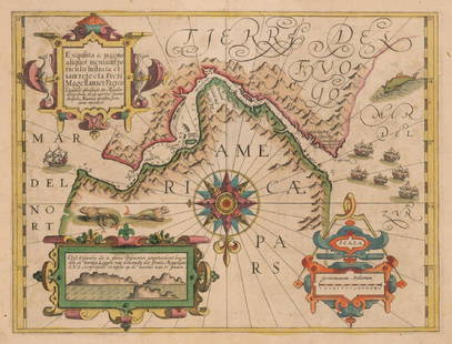
Sold2023J. DE HONDT, COLOR MAP OF STRAITS OF MAGELLANJoost de Hondt (Belgian 1563-1612), "Freti Magel Lanici Ac Novi Freti Vulgo, Le Maitre Exactissima Delineatio", hand colored map of the Straits of Magellan, Le Maire Strait, Fire Lands and the southerSee Sold Price
Sold2019Strait of Magellan Map[Strait of Magellan Map] , "Fretum Magellannicum", by Theodore De Bry, Frankfurt, 1601, copper engraved, depicting ships, natives, a penguin and a snail, 6 1/2 in. x 11 3/4 in., framed IMPORTANT: AllSee Sold Price
Sold2022Large chart of Strait of Magellan 1787Heading: (South America) Author: Schraembl, Franz Anton Title: Karte der Magellanischen Strasse von Herrn Don Iuan de la Cruz Cano y Olmedillo... Place Published: Wien Publisher:Jos. Gerstner DatSee Sold Price
Sold20211705 de Fer Map of the Straights of Magellan -- LeTitle: 1705 de Fer Map of the Straights of Magellan -- Le Detroit de Magellan Cartographer: N de Fer Year / Place: 1705, Paris Map Dimension (in.): 8.8 X 13.3 in. This attractive map provides excellenSee Sold Price
Sold2023Extremité Meridionale de l'Amérique Tierra del Fuego Magellan Str BONNE 1788 map[Cook 2e Voyage] Extremité Meridionale de l'Amérique // Partie Est de la Terre de Feu, le Détroit de Le Maire et partie ouest de la terre des Etats // Canal de Noël // Suite de la CôteSee Sold Price
Sold2017Chatelain: Carte Paraguai Chili Detroit Magellan, 1719Map: Carte du Paraguai, du Chili, du Detroit de Magellan Cartographer: Chatelain Place & Date: Amsterdam / 1719 Size: 20 1/4" x 15 3/4" Chatelain's superbly detailed map of southern South America exteSee Sold Price
Sold2017A Collection Canadian Silver One Dollar Coins.A Collection Canadian Silver One Dollar Coins. Dating 1964, 1965, 1966 and 1967. Together with a 1916 5 cent coin, a 1967 25 cent coin, a 1987 400th Anniversary of Detroit de Davis Strait Canada DollaSee Sold Price
Sold2017Mercator: Strait of Magellan, Terra del Fuego, 1613Exquisita & magno aliquot mensium periculo Lustrata et iam retecta Freti Magellanici Facies . . . By: Gerard Mercator. Date: 1613 / Amsterdam. Dimensions: 14 x 18 inches (35.5 x 45.7 cm) This is an auSee Sold Price
Sold2016Strait of Magellan, Jodocus Hondius 1606-33Title: Freti Magellanici ac novi Freti vulgo Le Maire Subject: Strait of Magellan Maker: Jodocus Hondius Date: 1606-33, Amsterdam Size: 15.1 x 19.25 inches This is one of the best known early maps ofSee Sold Price
Sold2023Lot of 3 Books by Rockwell Kent, Voyaging The Strait Of Magellan 1924, Salamina 1935, N by E 19351) Voyaging Southward From The Strait Of Magellan, with illustrations by the Author. Published by Halcyon House, New York 1924, Fourth Printing. Good condition. 2) Salamina, illustrated by the Author.See Sold Price
Sold2020STRAITS of MAGELLAN & TIERRA DEL FUEGO calledTitle: STRAITS of MAGELLAN & TIERRA DEL FUEGO called MAGELLANICA, with Cape Horn Date/Period: 1642-1665 Materials: Copperplate engraved Size: 18 1/4 x 21”. Maps shows the southern most tip of SouthSee Sold Price
Sold2023GROUP OF 5 HAND COLORED MAPS OF THE AMERICASGroups of five hand colored antique maps of the Americas, comprising "America Merioio-Nalis (South American)" circa 1620, "Tabula Magellanica Qua Tierre Del Fuego (Strait of Magellan)" circa 1640, "IlSee Sold Price
Sold201818th C. Map of Australia w/Strait of Magellan18th c. framed map of Australia w/the Strait of Magellan. Copper engraved map, hand colored, w/ large colored pictorial cartouche, by Bernaidus Joannis Manasterienfis. Visible paper measures approximaSee Sold Price
Sold2018Rockwell Kent's Voyaging inscribed - 1st Russian ed.Heading: Author: Kent, Rockwell Title: Voyaging Southward from the Strait of Magellan - Russian Language Edition Place Published: Moscow Publisher: Date Published: 1966 Description: </See Sold Price
Sold2023TWO 17TH CENTURY MAPS OF THE STRAIGHT OF MAGELLANTwo 17th century maps of the Straight of Magellan comprising, "Du Destriot De Magellan," circa 1669 hand colored engraving depicting the lower part of Terra del Fuego, by Gerardus Mercator (Flemish 15See Sold Price
Sold2022DARDANELLES. Sestos; Abydos; Detroit Gallipoli (Gallipoli Strait). MALLET 1683TITLE OF THE PRINT: 'Sestos; Abydos; Detroit de Gallipoli' (De L'Europe) Shows the forts of Sestos and Abydos, situated opposite each other on the Hellespont, guarding the Dardanelles straits DATE PRISee Sold Price
Sold2019Bellin: Le Maire Strait / Tierra del FuegoMap Title: Carte du Detroit de le Maire Cartographer: Bellin Place / Date: Paris / 1753/1760 Size: 10 7/8" x 7 5/8" Condition: b&w; light overall age toning; margins extended with contemporary paper tSee Sold Price
6 days LeftJasper52L'Allemagne, La Boheme, et La Hongrie; avec…partie de Pologne. BONNE 1780 mapUS$60
6 days LeftJasper52Les Royaumes de Suede, de Danemark et de Norwege. Scandinavia. BONNE 1787 mapUS$25
6 days LeftJasper52Le Nord de l'Europe contenant le Danemark… Scandinavia Russia. BONNE 1780 mapUS$35
1 day LeftTrillium Antique Prints & Rare BooksBonne - Pair of Maps (Eastern & Northern Hemisphere)US$75
5 days LeftUniversity ArchivesRare 18th C. French Engraving Showing Chilean Hockey Player & Other Exotic CustomsUS$140
May 30NY Elizabeth 1792 OLD INDIA HISTORY ANTIQUE ILLUSTRATED WITH MAPS OF THE EIGHTEENTH CENTURY IN FRENCHUS$50


![Détroit de Magellan. Strait of Magellan. Chile. BONNE 1790 old antique map: [Voyage des Capitaines Byron, Vallis et Carteret] Détroit de Magellan avec les Plans des principaux Ports, Bayes &c. de ce Détroit // Havre Swalow ou de l'Hirondelle // Baye du Cap Upright // Ba](https://p1.liveauctioneers.com/5584/294908/156576972_1_x.jpg?height=310&quality=70&version=1688565030)


![Relation d'un voyage fait...aux Cotes d'Afrique.: [Africa] Froger, Francois. Relation d'un voyage fait en 1695, 1696 & 1697 aux Cotes d'Afrique, detroit de Magellan, Bresil, Cayenne & isles Antilles, par une escadre des vaisseaux du Roy, commandee pa](https://p1.liveauctioneers.com/179/268856/140615973_1_x.jpg?height=310&quality=70&version=1668545725)

![Entrée de Norton & Détroit de Bhering. Bering Strait Norton Sound BONNE 1790 map: TITLE/CONTENT OF MAP: [Cook 3e Voyage] Carte de l'entrée de Norton et du Détroit de Bhering, où l'on voit le Cap le plus Oriental de l'Asie et la pointe la plus Occidentale de l'Amé](https://p1.liveauctioneers.com/5584/326888/175994368_1_x.jpg?height=310&quality=70&version=1713903186)

![Strait of Magellan Map: [Strait of Magellan Map] , "Fretum Magellannicum", by Theodore De Bry, Frankfurt, 1601, copper engraved, depicting ships, natives, a penguin and a snail, 6 1/2 in. x 11 3/4 in., framed IMPORTANT: All](https://p1.liveauctioneers.com/268/150890/76180328_1_x.jpg?height=310&quality=70&version=1569336980)


![Extremité Meridionale de l'Amérique Tierra del Fuego Magellan Str BONNE 1788 map: [Cook 2e Voyage] Extremité Meridionale de l'Amérique // Partie Est de la Terre de Feu, le Détroit de Le Maire et partie ouest de la terre des Etats // Canal de Noël // Suite de la Côte](https://p1.liveauctioneers.com/5584/294908/156576945_1_x.jpg?height=310&quality=70&version=1688565030)