Sold2019Group of Two MapsAn Accurate Map Of Turky (sic) in Europe Drawn from the best Authorities 8 1/4" x 11 3/4" (sight) hand colored together with Tabula Freti Siculi Charibdis et ScyllaeSee Sold Price
Sold20232 Framed Maps of Canada & U.S.Group of two framed maps depicting Canada and the United States. One map depicting the East Coast of the United States as well as southeastern Canada. One map depicting Lake Superior and south-centralSee Sold Price
Sold2021A GROUP OF TWO 18TH CENTURY MAPS OF THE AMERICAS,A GROUP OF TWO 18TH CENTURY MAPS OF THE AMERICAS, LONDON AND PARIS, 1736-1780, two hand-colored engravings on paper, comprising, "FLORIDA Called by ye French LOUISIANA," after works by Herman Moll (16See Sold Price
Sold2022(ON-19) EARLY TRAIL OF TEARS EPHEMERA DOCUMENTS CHOCTAW NATIONEarly 19th collection of documents that includes two maps. The group with no odors and in clean condition. 1) A map with cover note that is hand drawn and lightly colored showing vacant landsaround deSee Sold Price
Sold2020Grp: 12 Regional Maps of AfricaGroup of twelve 18th and 19th c. regional maps of Africa. Includes two maps of the North African coast; one map of Madagascar; one page with seven inset maps of the major islands of Africa; one map ofSee Sold Price
Sold2021Disneyland "45 Years of Magic" Signed Map Fine ADisneyland "45 Years of Magic" Signed Map Fine Art Lithographs Group of Two (Walt Disney, c. 2000). On July 17th, 2000, the world's first Theme Park celebrated its 45th birthday. In the years since itSee Sold Price
Sold2024After PIRANESI: Group of 8 EtchingsGroup of six antique etchings after Piranesi depicting studies of Classical columns, urns, and architectural blueprints, together with two topographical maps, "Topografia delle fabbriche scoperte nellSee Sold Price
Sold2018Group of 19thC New York Illustrated BooksGroup of two 19th century New York Illustrated Books: 1) Abstract of Title of Kips Bay Farm, in the City of New York, with all known maps relating thereto, also, the early history of the Kip family anSee Sold Price
Sold2020Grp: 7 Maps of IndiaGroup of seven maps of India. Includes two hand colored maps by Pierre Duval (1618-1683), "Presquisle de L'Inde de ca le Gange" and "Empire Du Mogol"; three maps by Girolamo Ruscelli (1500-1566), "TabSee Sold Price
Sold2020Grp: 10 Maps of British Cities w/ 1 Map VeniceGroup of maps of British cities. Includes one map of Birmingham; two road maps for the London area: "A Map of the New Roads & c. from Westminster Bridge" and "A Plan of the intended New Road from PadiSee Sold Price
Sold2022Two railroad framed maps:Nickel Plate - the New York, Chicago, St. Louis RR, 18"x34", AND Detroit United Railways Interurban Lines, 11"x34"See Sold Price
Sold2017Sheridan's Memoirs Civil War 1888Personal Memoirs of P.H. Sheridan. NY: Webster, 1888. 1st ed. Two vols. Folding maps. Illust. Covers with Sheridan on a horse.See Sold Price
Sold2019Group of Early Maps of New Mexico(1) Rand, McNally & Co.'s New Commercial Atlas of America - Map of New Mexico. Copyright, 1911, by Rand, McNally & Co. 23 3/4 x 31 1/4 inches (2) Geologic Map of New Mexico. Two-part folding map. PartSee Sold Price
Sold20242 VOLUMES, FOLIO, THE COMPLETE ATLAS OF MODERN CLASSICAL, AND CELESTIAL MAPS, 1873The Complete Atlas of Modern Classical and Celestial Maps, in two Volumes. London: Edward Stanford. 1873. Folio. For display and reference in your library. Condition as shown. Group: 17.75" x 14.5" xSee Sold Price
Sold2022SENEX, JOHN. Group of 25 full-sheet and double-page engraved maps in fine original hand-color.SENEX, JOHN. Group of 25 full-sheet and double-page engraved maps in fine original hand-color. 12 large two-sheet double-page maps measuring approximately 40x26 inches each; 13 unfolded full-sheet mapSee Sold Price
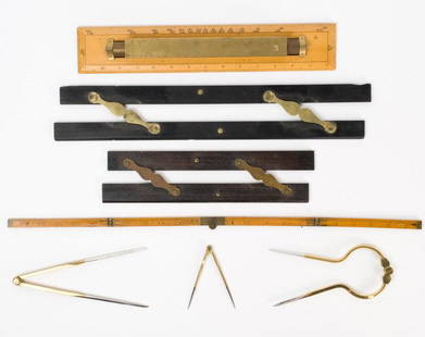
Sold2021Antique & Vintage Marine Map Chart AccessoriesA group of six very good marine map chart accessories, consisting of: two antique ebony & brass parallel rules - the 12" rule stamped THREADWELL LONDON, the 18" rule with minor chips, a 15" antique brSee Sold Price
Sold2017(3) EARLY MAPS and a PRINT AFTER WILLIAM BLAKEIncluding: 1886 Fulton's Territory of Alaska, Hawaiian Group or Sandwich Islands, New Zealand, Feejee Islands, 1867 "The World in Two Hemispheres" by Mitchell (colored) and "The Day of Judgement" prinSee Sold Price
Sold2023Group of California Maps/Touring Books.Includes: 2 Denny & Co. Pocket Maps of Mendocino County and Part of Lake County, and Humboldt County, with two more in poor condition (Napa and Lake County); 2 tract maps, of Redondo Villa and ImperiaSee Sold Price
Sold2020Grp: Mixed Atlas PagesLarge group of pages from a variety of early atlases. The majority are from two atlases: Mallet and "Della Geografia di Tolomeo." Maps from Mallet include including maps of Asia, eastern India, China,See Sold Price
Sold2020Grp: Books on the Eastern U.S.Group of books and maps on the Eastern United States. Includes The John Henry County Map of Virginia 1770 by Louis B. Wright (two copies); Tidewater Towns: City Planning in Colonial Virginia and MarylSee Sold Price
Sold2023Inuit Carved Soapstone Figural Group Two FacesInuit Carved Soapstone Figural Group Two Faces. Measures 9 inches H x 6 W x 3.5 deep.See Sold Price
Sold2018CARVED MARBLE FIGURAL GROUP TWO DRAPED CUPIDSA carved marble figural group depicting two draped cupids under egg and dart decorated shelf. Ht: 40.5" Wd: 20" Dpth: 10"See Sold Price
Sold2019Two Maps by the Hydrographic Office U. S. Navy,Two Maps by the Hydrographic Office U. S. Navy, consisting of "China- East Coast- Hwangpoo River, Kaokiao Creek to Yangtzepoo Creek," 1931, H. - 42 in., W. - 30 in.; together with "China- East Coast-See Sold Price
Sold2024Two Maps of the United States by William Faden (London, 1785 and 1796)Two Maps of the United States by William Faden (London, 1785 and 1796) Two hand-colored maps engraved by William Faden (British, 1749-1836), London, 1785 and 1796. Titled "The United States of North ASee Sold Price
May 22Dreweatts Donnington PrioryƟ A group of approximately one hundred and fifty-two mainly Chinese auction catalogues 國£100
1818 AuctioneersAntiquarian. Guyon, [Jeanne Marie] - The Life of Lady Guion, Written by herself in French, Now£22
2 days LeftOriental Art AuctionsA RARE NON COLORED PRINTED FRENCH MAP OF THE ARABIC WORLD DURING THE OTTOMAN EMPIRE (ARABIA€1,000
1818 AuctioneersLiterature. Anthony Trollope. Two titles: The Last Chronicle of Barset. London: Smith, Elder and Co.£60
May 23Potter & Potter Auctions[SARTAIN, William (1843-1924), engraver]. Group of Two Blac...US$100(1 bid)
2 days LeftPotter & Potter Auctions[NEW YORK CITY – PICTORIAL MAPS]. Group of 3 pictorial maps...US$200(1 bid)
4 days LeftThousand Planet Auction HouseGroup of Two Ancient Indus Valley Carnelian Beads, Circa 2500-1500 BCEUS$10


![Antiquarian. Guyon, [Jeanne Marie] - The Life of Lady Guion, Written by herself in French, Now (1 of 2)](https://p1.liveauctioneers.com/8084/327245/177443504_1_x.jpg?height=282&quality=70&version=1715177021)


![[SARTAIN, William (1843-1924), engraver]. Group of Two Blac... (1 of 3)](https://p1.liveauctioneers.com/928/328184/176813695_1_x.jpg?height=282&quality=70&version=1714496988)
![[NEW YORK CITY – PICTORIAL MAPS]. Group of 3 pictorial maps... (1 of 3)](https://p1.liveauctioneers.com/928/325952/175495562_1_x.jpg?height=282&quality=70&version=1712935174)
![[GRANT, Ulysses S. (1822-1885), subject]. Group of Two Engr... (1 of 3)](https://p1.liveauctioneers.com/928/328184/176813644_1_x.jpg?height=282&quality=70&version=1714496988)


![[TOKENS - MAGIC]. Group of two Books on Magicians Tokens. ... (1 of 4)](https://p1.liveauctioneers.com/928/329228/177514451_1_x.jpg?height=282&quality=70&version=1715272280)


