Sold2023Ile de GUADELOUPE Marie-Galante Saintes Désirade. Antilles françaises 1876 mapTitle: Ile de GUADELOUPE Marie-Galante Saintes Désirade. Antilles françaises 1876 map Description: Guadeloupe; Inset maps of Ile de Désirade; Iles de la Petite Terre; Iles des Saintes;See Sold Price
Sold20231764 Map of Guadeloupe in Lesser Antilles -- Isle de la Guadeloupe les Saintes et Marie GalanteTitle: 1764 Map of Guadeloupe in Lesser Antilles -- Isle de la Guadeloupe les Saintes et Marie Galante Cartographer: J Bellin Year / Place: 1764, Paris Map Dimension (in.): 8.9 X 13.7 in. This is an aSee Sold Price
Sold2018Poison/Tardieu: Puerto Rico & Lesser AntillesMap: Carte des Iles Antilles Cartographer: Poirson//Tardieu Place/Date: Paris / 1803 Size: 16 5/8" x 13 5/8" Condition: folding map. outline color; overall age toning; minor browning and some stains aSee Sold Price
Sold2017Antigua, Guadeloupe, Caribbean Map, Thomson, 1817TITLE/CONTENT OF MAP: 'Antigua. Guadaloupe. Mariegalante &c' A map of the French and British Leeward islands of Guadeloupe, Marie-Galante & Antigua DATE PRINTED: 1817 IMAGE SIZE: Approx 53.5 x 65.0cm,See Sold Price
Sold2022Antigua, Guadeloupe & Marie-Galante. West Indies Caribbean. THOMSON 1817 mapTITLE/CONTENT OF MAP: 'Antigua. Guadaloupe. Mariegalante &c' A map of the French and British Leeward islands of Guadeloupe, Marie-Galante & Antigua DATE PRINTED: Published in 1817 IMAGE SIZE: Approx 5See Sold Price
Sold2023A new & accurate map of the isles of Guadaloupe, Marie-Galante. GIBSON 1759A new and accurate map of the isles of Guadaloupe, Marie-Galante &c. from the best authorities' by John Gibson (1759). Antique copperplate map, 12.0 x 19.5cm, 4.75 x 7.75 inches TITLE/CONTENT OF MAP:See Sold Price
Sold2018Bellin: Guadeloupe, Marie Galante, Les Saintes IslandsReserve Reduced! Title of Map: Carte de l'Isle de la Guadeloupe. Cartographer: Nicolas Bellin Place / Date: Paris / 1758 Size: 12 1/2" x 8 3/4" Condition: B&W; overall age-toning and some spotting priSee Sold Price
Sold2018Bellin: Lesser Antilles 2-Guadeloupe to Martinique 1764Suite des Isles Antilles 2. Partie A beautifully colored and preserved exemplar of Part II of Bellin's detailed map of the Lesser Antilles, featuring Guadeloupe, Martinique, and the islands in betweenSee Sold Price
Sold20201684 Pas kaart Van de Caribes Tusschen I. Barbados en IThis is an authentic antique map of the Lesser Antilles by Johannes Van Keulen. The map was published in Amsterdam in the year 1684. This is an impressive hand colored example of Van Keulen’s nSee Sold Price
Sold2017Carte de l'Isle de la Guadeloupe MapCarte de l'Isle de la Guadeloupe Map. Bellin's elegant map of Guadeloupe and the adjacent islands of Les Sainte and Marie Galante, with excellent topographical details, many place names, radiating rhuSee Sold Price
Sold2019Tabula Geographica Mexicae et Floridae, map of MexicoTabula Geographica Mexicae et Floridae, map of Mexico and Florida, hand colored copper engraving, "Carte du Mexique et de la Floride des Terres Angloises et des Isles Antilles", 1722 Jean Covens &See Sold Price
Sold2020Des Barres Map of NY Harbor*** START PRICE IS THE RESERVE *** [America] DES BARRES, Joseph Frederick Wallet (1729-1824). A Chart of New York Harbour with the Soundings Views of Land Marks and Nautical directions for the Use ofSee Sold Price
Sold20241920s Chanel no 22 and Chanel Bois de Ilesc1926 Parfums Chanel deluxe perfume presentation, Brosse Glassworks bottles for No. 22 and Bois des Iles (Wood of the Islands) in clear glass with flat gem facetted stoppers, paperlabels, underside moSee Sold Price
Sold2022Color map of San Francisco Chinatown 1885Heading: -1885 Author: Title: Official Map of Chinatown in San Francisco Place Published: San Francisco Publisher: Date Published: 1885 Description: Color lithographed map. 21.1See Sold Price
Sold2022CURIE (MARIE) Thèses présentées à la Faculté des Sciences de Paris pour...CURIE (MARIE) Thèses présentées à la Faculté des Sciences de Paris pour obtenir le grade de docteur des sciences physiques.. 1re thèse. Recherches sur les substances radiSee Sold Price
Sold2023Toyen (Czech 1902 - 1980)Pseudonym of Marie Čermínová Il était la proie des images - 1956 Gouache on paper 20,5 x 20,5 cm Signed lower right Provenance: Sale Calmels-Cohen, Paris, 22 June 2006, lot 165 PrSee Sold Price
Sold2024Blaeu's Tooneel des Aerdrycx - Fifth Volume with 55 Engraved MapsThis remarkable fifth volume of 55 maps with original hand-coloring is is Jan & Willem Blaeu's Tooneel des Aerdrycx, oft Nieuwe Atlas ? Vyfde Deel or Theatrum Orbis Terrarum, Dutch edition. This was pSee Sold Price
Sold2022Armand Guillaumin (1841-1927), "Paysage d’Ile de France", vers 1885, huile sur toile,Armand Guillaumin (1841-1927), "Paysage d'Ile de France", circa 1885, oil on canvas, signed, 81x65 cm; The work will be reproduced in the second volume of the Catalogue Raisonné Armand Guillaumin,See Sold Price
Sold2022Charles Camoin (1879-1965), "Environs de St-Tropez", huile sur toile, signée, 41x65Charles Camoin (1879-1965), "Environs de St-Tropez", oil on canvas, signed, 41x65 cm; The authenticity of this painting has been confirmed by Madame Anne-Marie Grammont-Camoin, and it will be includedSee Sold Price
Sold2022JEAN COCTEAU (1889-1963) Fleur des yeuxJEAN COCTEAU (1889-1963) Fleur des yeux signé et daté à la main Jean Cocteau 58; inscrit piece d'essai/original/Dessin de Jean Cocteau/Ceramiste Marie Madeleine Jolly (au revers) diam&#See Sold Price
Sold2022DES BARRES, JOSEPH FREDERICK WALLET The North East Shore of the Gulph of Mexico. London: circa 1780.DES BARRES, JOSEPH FREDERICK WALLET The North East Shore of the Gulph of Mexico. London: circa 1780. A very large hand-colored engraved map on four joined sheets. Overall 30 x 84 inches (76 x 214 cm).See Sold Price
Sold20241598 COSMOGRAPHY by Sebastian Munster antique RARE ILLUSTRATED w/ MAPS PIGSKINMUNSTER, Sebastian (1489-1552). Cosmographey, das ist, Beschreibung aller Länder, Herrschafften und fürnemesten Stetten des gantzen Erdbodens Cosmography: that is, description of all countries... BaSee Sold Price
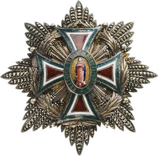
Sold2017ORDER OF OUR LADY OF GUADALUPEGrand Cross Star, 1st Class, instituted in 1854. Breast Star, 85 mm, Silver, brilliant cut rays, smooth and imitating the sequined embroidery, applied Order's cross in gold and enameled arms, wonderfuSee Sold Price
Sold2022Eugen Bracht(1842 Morges - 1921 Darmstadt) "Heidebach I". Originaltitel Das großformatige, impressionistische, auf den Gesamteindruck angelegte Gemälde gehört in eine in den 1890eSee Sold Price
5 days LeftLeon GalleryAbraham Ortelius (1527 - 1598) - Indiae Orientalis (Philippines/China/ India/ Southeast Asia)₱200,000
4 days LeftFreeman's | HindmanBELLIN, Jacques-Nicolas. Carte Reduite de L'Ocean Oriental ou Mer Des Indies. Paris, 1757. SecondUS$150
Jun 14Crescent City Auction GalleryAfter Marie Adrien Persac (French/Louisiana, 1823-1873), "Plantations on the Mississippi River fromUS$325
Jun 12Dan Morphy AuctionsBRUE'S MONUMENTAL WALL MAP OF TEXAS, UPPER CALIFORNIA & MEXICO, C. 1845US$500
4 days LeftFreeman's | HindmanGRANT, Ulysses S. Personal Memoirs. 1885-86. FIRST EDITION.US$150(1 bid)
Jun 14DuMouchellesRigobert Bonne (French, 1727-1794) Hand Colored Engraving Ca. 18th Century, Les Etats Unis DeUS$50(1 bid)
1 day LeftJasper521775-1780 North & South Carolina, Georgia and Virginia. By Bonne & RaynalUS$180(2 bids)
BonhamsEGYPT - ANTIQUITIES [Description de l'Égypte, ou recueil des observations et des recherches...£400
Featured3 days LeftPiguet Hôtel des VentesGiacometti (1902-1985), Lampadaire modèle figure dit aussi Tête de femme , sculpture en bronze,CHF 200,000


![Des Barres Map of NY Harbor: *** START PRICE IS THE RESERVE *** [America] DES BARRES, Joseph Frederick Wallet (1729-1824). A Chart of New York Harbour with the Soundings Views of Land Marks and Nautical directions for the Use of](https://p1.liveauctioneers.com/1968/163248/82424572_1_x.jpg?height=310&quality=70&version=1583340284)