Sold2019Two Maps; Unknown, "Charte von den NordwestkusteTwo Maps; Unknown, "Charte von den Nordwestkuste Americas Nach Vancouver," Prague, 1818, H. - 10 in., W. - 8 in.; together with Unknown, "Charte der neuen Niederlassungen in Ober Canada each der mythsSee Sold Price
Sold2019MAP - Jerusalem, Holy Land. DanckertsJerusalem, Holy Land. Cornelius Danckerts, De Stadt Ierusalem, 1718 (published). Hand Color. Great bird's-eye plan of the ancient holy city flanked by engravings of religious icons. At the bottom areSee Sold Price
Sold2019Unknown, "Charte von America," Prague, 1818, H. - 18Unknown, "Charte von America," Prague, 1818, H. - 18 1/2 in., W. - 12 3/4 in.See Sold Price
Sold2021Wright, Paul 1782 Holy Land Map. Jerusalem"A Correct Plan of the Antient City of Jerusalem" by Thomas Conder. Folio Copper Plate Published 1782, London for "The Complete British Family Bible…" by Paul Wright. Paper Size: 14.5 x 9.5 inch (37See Sold Price
Sold2023Wright, Paul 1782 Folio Holy Land Map. Jerusalem City"A Correct Map of the Antient City of Jersusalem and Parts Adjacent" Folio Copper Engraved Map Published 1782, London for "The Complete British Family Bible…" by Paul Wright. Drawn and Engraved by TSee Sold Price
Sold2019Unknown, "Charte von Nord America" Prague, 1818, H. -Unknown, "Charte von Nord America" Prague, 1818, H. - 18 3/8 in., W. - 123/4 in.See Sold Price
Sold20221850 Survey of Holy Land MAPS Jerusalem Bethlehem Canaan Bible Nativity Israel1850 Survey of Holy Land MAPS Jerusalem Bethlehem Canaan Bible Nativity Israel J.T. Bannisters “Survey of the Holy Land” is a rare, mid-19th-century history of Israel and Palestine. In thiSee Sold Price
Sold20221818 Map I Stati Uniti Nell America SettentrionaleHistoric Maps 1818 Rare Map Titled "I Stati Uniti Nell' America Settentrionale" by A.B. Borghi, Florence, Italy Choice Crisp Near Mint 1818-Dated, Four-Sheet Copper-Engraved, Hand-Colored Outlines, MaSee Sold Price
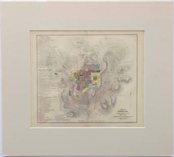
Sold2017Map of Jerusalem and Its Ruins, 1872Map: Jerusalem and Its Ruins Maker: Redding & Co Date: 1872 Size: Folio, 15.3 inches high x 19.75 inches wide Detailed plan of ancient biblical sites in the Holy City. Fine, Large Plan of Jerusalem PlSee Sold Price
Sold2016Modern Jerusalem, 1858Map: Jerusalem before the Roman Destruction Publishing: Sarony & Major, 1858 Medium: Hand colored lithograph Size: 13.5 x 15 inches Napoleon Sarony (1821-1896) was an American lithographer and a highlSee Sold Price
Sold2017I.H. Coccejo / Weigel: Map of Jerusalem, 1720Map: Jerusalem, "Ierusalem aus den Schrifften Iosephi" Cartographer: I.H. Coccejo. / Weigel Place & Date: Nuremberg / 1720 Size: 16 5/8" x 13" Condition: original color; overall age toning and minor sSee Sold Price
Sold2019Unknown, "Charte von den Vereinigten Staaten for NordUnknown, "Charte von den Vereinigten Staaten for Nord America mit Louisiana," Prague, 1818, H. - 13 1/2 in., W. - 17 3/4 in.See Sold Price
Sold2018Mallet: Antique View of Prague, 1683TITLE OF THE MAP: 'Prague' Decorative city view. Figures. Czech Republic. DATE PRINTED: 1683 IMAGE SIZE: Approx Overall page size 13 x 21cm approximately (5 x 8 inches); image size 10.5 x 14.5cm approSee Sold Price
Sold20191818 Neele Map of Kent -- KentTitle/Content of Map: 1818 Neele Map of Kent -- Kent Date: 1818, London Cartographer: S Neele Size: 9.8 X 7.8 in. This is a nice and rather scarce map of Kent, a county in south-east England, includinSee Sold Price
Sold2021Jerusalem & Palestine 1889Title/Content of Map: Jerusalem & Palestine 1889 Date Printed: 1889 Material/Medium: Paper Size: approx 11x14 inches Mast, Crowell & Kirkpatrick, Peerless Atlas of the World Reserve: $30.00 Shipping:See Sold Price
Sold2019Unknown, "Charte von America nach den Neusten BerichtenUnknown, "Charte von America nach den Neusten Berichten und Entdeckungen entworfen," Prague, 1818, H. - 18 in., W. - 12 5/8 in.See Sold Price
Sold2020Jerusalem - BirdTitle/ Content of Map:Jerusalem - Bird's Eye View Date Printed: 1983 Cartographer: Aharon Bier Material/Medium: paper Dimensions: Approx. 16x20, olded size approx. 4"x10". Additional Information: ApprSee Sold Price
Sold20211758 History of Saladin Egypt Sultan Crusades MAPS1758 History of Saladin Egypt Sultan Crusades MAPS Jerusalem Ptolemais Israel Saladin was a 12th-century sultan, known for being the first sultan of Egypt and Syria. His reign was highlighted by his mSee Sold Price
Sold2017Florimi Map of Jerusalem and Christ Crucifiction, 1595Map: 1595 Florimi Map of Jerusalem and Christ Crucifiction -- L'Antichissima citta di Gierusalemme come era nel tempo di N. S. Gisu Christo con le sur cechiaratione Cartographer: M. Florimi Year / PlaSee Sold Price
Sold2023Western Coast of the peninsula of Corea by Captn. Basil Hall. Korea 1818 mapTitle: Western Coast of the peninsula of Corea by Captn. Basil Hall. Korea 1818 map Description: Track of His Majesty's Ship Alceste and Lyra Sloop along the Western Coast of the peninsula of Corea' bSee Sold Price
Sold20221590 Map of Jerusalem from "Civitates Orbis Terrarum" by Hogen & Bran1590 Map of Jerusalem from "Civitates Orbis Terrarum" by Hogen & Bran 1p, measuring 21" x 16", [Cologne, Germany], undated [Ca. 1590]. A beautiful color copper etching map of Jerusalem, printed inSee Sold Price
Sold2022Rare 1818 Map Showing the Battle of Bunker Hill Sketched by Witness Henry de BerniereRare 1818 Map Showing the Battle of Bunker Hill Sketched by Witness Henry de Berniere Engraved map, Ca. 1818, Charlestown, MA. Entitled "Sketch of the Action on the Heights of Charlestown 17 June 1775See Sold Price
Sold2015[Mantua, Province, Maps] Raineri, 1818A VERY RARE LARGE FOLDED MAP OF THE PROVINCE OF MANTUA IN ITS ORIGINAL CARDBOARD CASEAPPARENTLY NO COPY IN USARaineri, Giuseppe. Carta topografica della provincia di Mantova a sua Altezza imperiale ilSee Sold Price
Sold2018Map of Jerusalem - Engraving - Cologne, 1575Hierosolyma, Urbs Sancta. Ludeae, Totiusque Orientis Longe Clarissima, Qua Amplitudine Ac Magnificentia Hoc Nostro Aevo Conspicua Est. Map of Jerusalem - engraving from Georg Braun and Frans HogenburgSee Sold Price
6 days LeftSchilb Antiquarian Rare Books1790 Life of Jesus Christ Fleetwood Bible ART Miracles Jerusalem MAP Holy LandUS$120(7 bids)
6 days LeftSchilb Antiquarian Rare Books1870 BEAUTIFUL Life of Jesus Christ Fleetwood Bible ART Miracles Jerusalem MapUS$150(7 bids)
16 hrs LeftJasper521738 BIBLE in DUTCH ILLUSTRATED w/ MAPS MASSIVE FOLIO in DUTCH antique BIBLIAUS$600
4 days LeftTrillium Antique Prints & Rare BooksDavid Roberts, RSE - Jerusalem from the SouthUS$500(1 bid)
BonhamsBEWICK (THOMAS AND JOHN) History of British Birds, 2 vol. (inc. 2 supplements), 1797-1804-1821; ...£700
7 hrs LeftDOYLE Auctioneers & AppraisersSet of Twelve Satirical Anthropomorphic Maps of EuropeUS$400(1 bid)
6 days LeftSchilb Antiquarian Rare Books1977 JRR Tolkien 1st ed Silmarillion Lord of the Rings Middle Earth + MAPUS$155(7 bids)
6 days LeftSchilb Antiquarian Rare Books1848 Emory Military Reconnaissance 1ed California MAP Indians Texas New MexicoUS$5(5 bids)
6 days LeftSchilb Antiquarian Rare Books1890 Livingstone 1ed In Darkest Africa Henry Stanley Emin Pasha Expedition MAPUS$145(8 bids)
6 days LeftSchilb Antiquarian Rare Books1818 FAMOUS Journal of James Riley Shipwreck Brig Commerce Arabs Morocco AfricaUS$130(4 bids)
5 days LeftLeonard Auction, a division of The Leonard CompanyEuropean and United States Map AssortmentUS$150


![1590 Map of Jerusalem from "Civitates Orbis Terrarum" by Hogen & Bran: 1590 Map of Jerusalem from "Civitates Orbis Terrarum" by Hogen & Bran 1p, measuring 21" x 16", [Cologne, Germany], undated [Ca. 1590]. A beautiful color copper etching map of Jerusalem, printed in](https://p1.liveauctioneers.com/6306/250544/130128283_1_x.jpg?height=310&quality=70&version=1654115529)

![[Mantua, Province, Maps] Raineri, 1818: A VERY RARE LARGE FOLDED MAP OF THE PROVINCE OF MANTUA IN ITS ORIGINAL CARDBOARD CASEAPPARENTLY NO COPY IN USARaineri, Giuseppe. Carta topografica della provincia di Mantova a sua Altezza imperiale il](https://p1.liveauctioneers.com/2198/81135/42158607_1_x.jpg?height=310&quality=70&version=1447166404)


![[Maps & Atlases] Speed, John: The Turkish Empire (1 of 2)](https://p1.liveauctioneers.com/65/332523/179335176_1_x.jpg?height=282&quality=70&version=1717709446)


