Sold2022Northwestern America Showing the Territory Ceded by Russia to the United StatesPublication Date: 1887 Title: Northwestern America Showing the Territory Ceded by Russia to the United States Cartographer: WM. M. BRADLEY & BRO. Publisher: WM. M. BRADLEY & BRO. Height: 11.5 Width: 1See Sold Price
Sold2022Wonderful 1872 map of Alaska with orig. hand coloringVery nice and uncommon two-page map titled “Northwestern America showing the Territory ceded by Russia to the United States.” Map was published by H. H. Lloyd in 1872, just five years afteSee Sold Price
Sold20181871 Mitchell Antique Map of AlaskaTitle/Content of Map: 1871 Mitchell Map of Alaska -- North Western America Showing the Territory Ceded by Russia to the United States Date Printed: 1871, Philadelphia Cartographer: S Mitchell Size: 11See Sold Price
Sold2017Mitchell: Map of North Western America/Alaska, 1870Map: North Western America showing the territory ceded by Russia to the United States Cartographer: S. A. Mitchell Place & Date: Philadelphia / 1870 Size: 14 1/2" x 11 5/8" Condition: full color; lighSee Sold Price
Sold20211858 map of N. America showing Gold RegionsMap dated 1858 and found in an 1869 edition of Mitchell’s School Atlas. An early map showing Alaska as U. S. territory. Alaska labeled “Russia America; Ter’y of United States.”See Sold Price
Sold2018Map of the United StatesTitle/Content of Map: Map of the United States Date Printed: 1838 Cartographer: ANONYMOUS Material/Medium: Size: 11.6X14.5 Map showing topography, states, lg. MO territory, Northwestern territory (WI,See Sold Price
Sold2018North AmericaTitle/Content of Map: North America Date Printed: 1820 Cartographer: Size: 10.6X8 Polar projected continent map showing the United States and the much larger Louisiana Territory. From the Seventh editSee Sold Price
Sold2024Three United States Mint Silver ATB Quarter Proof SetsIncludes (1) 2011 non-silver proof quarters set. (2) Silver America the Beautiful and U.S. Territories 2009, 2010, and 2105. (3) Standard 2011. Most of these sets are showing rainbow and similar toninSee Sold Price
Sold202320th C. Alaskan Totem Pole w/ Thunderbird by RavenNorth America, northwestern United States, Alaska, ca. mid to late 20th century CE. A fine hand carved wooden totem pole featuring a marvelous Thunderbird with outspread wings presenting meticulouslySee Sold Price
Sold202221st C. Alaskan Inuit Ceramic Doll w/ DrumNorth America, Northwestern United States, Alaska, ca. 21st century CE. A charming cotton and hide doll with a wooden drum. The ceramic head is wrinkled to resemble an elderly Inuit man, with inlaid gSee Sold Price
Sold202220th C. Tlingit / Haida Wood Tobacco Pipe, Fox Form**Originally Listed At $500** North America, Northwestern United States or Canada, likely Tlingit or Haida, ca. mid-20th century CE. A handsome hand-carved wooden pipe in the form of a fox inlaid withSee Sold Price
Sold2023Oregon Eocene Period Petrified / Fossilized Wood SlabOriginally listed at $400 North America, Northwestern United States, Oregon, Eocene period, ca. 37 million years ago. A beautiful flab of cut and polished fossilized or "petrified" wood, featuring gorSee Sold Price
2023FOSSILIZED NORTH AMERICAN BISON HORNNorth America, Northwestern United States, Alaska, Pleistocene, ca. 250,000 to 10,000 years ago. A fantastic, fossilized horn core from a prehistoric North American bison known as Bison antiquus. MeasSee Sold Price
Sold2023Large Chunk Cascade Mountains Raw Obsidian Stone**Originally Listed At $600** North America, Northwestern United States / Canada, Washington & British Columbia, North Cascades region, ca. millions of years ago. A large raw chunk of obsidian! The suSee Sold Price
Sold202117th C. European Iron & Brass Trade Beads & Button (12)Northwestern Europe, England / North America, United States, Georgia, ca. 17th to 18th century CE. An interesting collection of brass and tin artefacts brought by English colonizers to America as tradSee Sold Price
Sold2024Title: 1834 North America by Thomas Starling Date/Period: 1834 Materials: Hand colored, steelTitle: 1834 North America by Thomas Starling Date/Period: 1834 Materials: Hand colored, steel engraved Size: 6 1/2 x 4 inches. This map depicts North America in 1834, showing the United States' westerSee Sold Price
Sold2022(CIVIL WAR.) P.S. Duval & Son. Military Map of the United States & Territories(CIVIL WAR.) P.S. Duval & Son. Military Map of the United States & Territories Showing the Location of the Military Posts, Arsenals, Navy Yards, & Ports of Entry. Hand-colored lithographed pocket mapSee Sold Price
Sold20221893 Government Map of Civil War Era United States -- Map of the United States of America ShowingTitle: 1893 Government Map of Civil War Era United States -- Map of the United States of America Showing the Boundaries of the Union and Confederate Geographical Divisions and Departments CartographerSee Sold Price
Sold2018United States of America Territory of Florida, 1835Tallahassee, Florida. $1,000 Issued 6% Coupon Bond, Black print with simple black border printed on blueish paper, Company title at top, S/N 739, The state acknowledges it is indebted to the Union BanSee Sold Price
Sold20221893 Government Map of Civil War Era United States -- Map of the United States of America ShowingTitle: 1893 Government Map of Civil War Era United States -- Map of the United States of America Showing the Boundaries of the Union and Confederate Geographical Divisions and Departments; Plate CLXIVSee Sold Price
Sold20221893 Government Map of Civil War Era United States -- Map of the United States of America ShowingTitle: 1893 Government Map of Civil War Era United States -- Map of the United States of America Showing the Boundaries of the Union and Confederate Geographical Divisions and Departments; Plate CLXIISee Sold Price
Sold2019...United States and Territories Showing the Extent ofReserve Reduced! Title: ...United States and Territories Showing the Extent of Public Surveys. Publication Date: 3/12/1905 Cartographer: KING, HARRY Publisher: G.L.O. Size (inches): 58.5 x 81 Inset shSee Sold Price
Sold2020Map of the United States and Territories Showing theTitle: Map of the United States and Territories Showing the Extent of Public Surveys and Other Details Publication Date: 1866 Cartographer: WILSON, HON. JOS. S. Publisher: GENERAL LAND OFFICE Size: 28See Sold Price
Sold2022NATIONAL COMMERCIAL TRAVELERS ASSOCIATION SUPERVISED SERVICE PORCELAIN SIGN W/ IRON HANGER.DSP. Seldom seen CA. 1940's Porcelain Sign for National Commercial Travelers Association showing United States of America graphic throughout each side. CONDITION: Side one presents very well with exceSee Sold Price
3 days LeftJasper52United States of North America. Early territorial boundaries. LOWRY 1860 mapUS$380
Featured3 days LeftJasper52United States of North America. Early territorial boundaries. LOWRY 1859 mapUS$380
3 days LeftJasper52United States of North America, Pacific States by Joseph Wilson Lowry 1860 mapUS$340
3 days LeftJasper52United States of America. California Gold region. THOMAS, COWPERTHWAIT 1852 mapUS$380
5 days LeftTrillium Antique Prints & Rare BooksCarey, pub. 1796 - Map of the State of New JerseyUS$75(1 bid)
5 days LeftRR AuctionThomas Jefferson Letter Signed as Secretary of State, Addressed from New York to Thomas Mifflin,US$2,500
5 days LeftBrunk AuctionsCompanion Mezzotints By Edward Savage, Benjamin Franklin & George WashingtonUS$1,000
Sep 30Rapid Estate Liquidators and Auction Gallery1914 German Empire Iron Cross in Original Case WWIUS$130(3 bids)
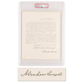
5 days LeftRR AuctionAbraham Lincoln Document Signed as President, Ordering Pennsylvania to Furnish Additional Troops forUS$1,000


![[CIVIL WAR] Salmon P. Chase's 1831 Psalm Book (1 of 4)](https://p1.liveauctioneers.com/7226/343679/186654913_1_x.jpg?height=282&quality=70&version=1726238840)