Sold2021Town city 'Plan de la Ville de Louvo'. Lopburi,TITLE/CONTENT OF MAP: 'Plan de la Ville de Louvo [Plan of the city of Lopburi]' The top image on the right hand side shows the entire map. To view a close up of the map showing the level of printed deSee Sold Price
Sold2017Bellin: Antique Plan of Lopburi, Thai Capital, 1750Map: Plan de la Ville de Louvo Demeure ordinaire des Rois de Siam Cartographer: Bellin Place & Date: Paris / 1750/1760 Size: 10 3/8" x 9 1/8" Condition: b&w; light overall age toning; some minor spottSee Sold Price
Sold202118TH C. PLAN OF THE SIAMESE ROYAL COMPOUND BY JACQUES"Plan de la ville de Louvo, demeure ordinaire des Rois de Siam", (Lavo, Thailand", copperplate engraving on laid paper, 1746-1759, published by Antoine Francois Prevost, Paris, from "Historie GeneraleSee Sold Price
Sold2022Engraving of Guillaume DHEULLAND Plan de la Ville de Paris 1756This is Dheulland's historical view of Paris, a fascinating mid-18th century piece showing the city as it stood during the reign of Charles IX, that is, sometime between 1560 and 1574. Published in PaSee Sold Price
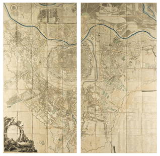
Sold2019Plan de la Ville de Meaco'. Kyoto town city plan,TITLE/CONTENT OF MAP: 'Plan de la Ville de Meaco A.Quartier de Dayri ou Empereur hereditaire B. Palais du Cubosama [Plan of the city of Kyoto]' DATE PRINTED: 1752 IMAGE SIZE: Approx 20.5 x 29.0cm, 8 xSee Sold Price
Sold2019French, "Plan de la Ville de Londres," c. 1768, H.- 12French, "Plan de la Ville de Londres," c. 1768, H.- 12 5/8 in., W.- 9 1/8 in.See Sold Price
Sold2022AN ANTIQUE PRINTED MAP BY J. N. BELLIN, Paris 1752. PLAN DE LA VILLE DE MEACO. CopperplateAN ANTIQUE PRINTED MAP BY J. N. BELLIN, Paris 1752. PLAN DE LA VILLE DE MEACO. Copperplate Uncoloured. A well engraved and detailed plan of the port and city of Meaco, present-day Kyoto. Jacques NicolSee Sold Price
Sold2019French "Plan de la Ville de Cochin," 1761, engraving,French "Plan de la Ville de Cochin," 1761, engraving, H.- 10 1/4 in., W.- 15 5/8 in.See Sold Price
2017Bellin: Plan De La Ville De Port Royal, 1763Map Title: Plan De La Ville De Port Royal Maker: Jacques Bellin Printed in Paris Publishing Date: Circa 1763 Dimensions: 9 x 11.5 inches Jacques-Nicolas Bellin(1703-1772) was a French cartographer, hySee Sold Price
Sold2018Austria.- Grimm (Maximilian von) Grundriss der Kl: Kl:Austria.- Grimm (Maximilian von) Grundriss der Kl: Kl: Haupt und Residenzstadt Wien mit ihren Vorstadten nach den Neuen Hausnumern 1797 / Plan de la Ville de Vienne et de ses Fouxbourgs avec le DenombSee Sold Price
Sold202119th Century Map of MemphisPLAN DE LA VILLE DE MEMPHIS (ETATS-UNIS) 40,000 HABITANTS pen and ink with watercolor hand drawn drainage system map, circa 1870. Depicts a grid street plan of the city of Memphis with labeled streetSee Sold Price
Sold2022Nicolas de La Mare (French, 1639–1723), Antoine Coquart (French, 1668–1707), and Nicolas de FerNicolas de La Mare (French, 1639–1723), Antoine Coquart (French, 1668–1707), and Nicolas de Fer (French, 1646-1720), "Cinquieme Plan de la Ville de Paris," c. 1705, hand-colored map, preSee Sold Price
Sold2016c. 1770 Georgeous Hand-Colored Plan of BostonColonial America Hand-Colored Plan of Boston Town and Harbor by Bellin c. 1770 Colonial Era, “Plan de la Ville de Boston et Ses Environs,” Jacques Nicolas Bellin, Choice Crisp Extremely Fine. ThisSee Sold Price
Sold2018Bellin: Antique Map of Early Boston, 1757Title/Content of Map: Plan de la Ville de Boston et ses Environs Cartographer: Bellin Place & Date: Paris / 1757/1760 Size: 10 5/8" x 6 3/8" Condition: b&w; light overall age toning; a few spots in thSee Sold Price
Sold2017Bellin: Antique Plan of Buenos Aires, 1758Map: Plan De La Ville De Buenos-Ayres... Publication Date: 1758 Authors: DIDOT, BELLIN, JACQUES NICOLAS, ELDER Publisher: DIDOT Size: Octavo – 7.00 H x 10.90 W Inches Tom. XIV, No.2. skilled modernSee Sold Price
Sold20211750 Bellin Map of Beijing (Peking) -- Plan de la VilleTitle: 1750 Bellin Map of Beijing (Peking) -- Plan de la Ville de Peking Cartographer: J Bellin Year / Place: 1750, Paris Map Dimension (in.): 8.4 X 6.5 in. This is a fascinating plan of Beijing (PekiSee Sold Price
Sold20201750 Bellin Map of Beijing (Peking) -- Plan de la VilleTitle: 1750 Bellin Map of Beijing (Peking) -- Plan de la Ville de Peking Cartographer: J Bellin Year / Place: 1750, Paris Map Dimension (in.): 8.4 X 6.5 in. This is a fascinating plan of Beijing (PekiSee Sold Price
Sold2018Bellin: Plan of Kyoto, JapanMap: Plan de la Ville de Meaco [Kyoto] Cartographer: Bellin Place & Date: Paris / 1752/1760 Size: 10 3/4" x 7 1/2" Condition: b&w; light overall age toning; margins extended with contemporary paper toSee Sold Price
Sold2017Mallet: Antique Miniature Santo Domingo Plan, 1683Map: Plan de la Ville de San-Domingo Cartographer: Mallet Place & Date: Paris / 1683 Size: 4 1/4" x 6" Condition: b&w; light overall age toning A charming bird's eye view of the old walled city of SanSee Sold Price
Sold2018Mallet: View of Santo Domingo City, 1683Plan de la Ville de San-Domingo Mallet's charming bird's eye view of the old walled city of Santo Domingo, in a beautifully colored example. From his Description de l'Univers. Cartographer: Mallet PlaSee Sold Price
Sold2017Bellin: Antique Plan of Town of Siam (Ayutthaya), 1750Map: Plan de la Ville de Siam Cartographer: Bellin Place & Date: Paris / 1750/1760 Size: 10 1/4" x 7 1/2" Condition: b&w; light overall age toning; a few small spots; margins extended with contemporarSee Sold Price
Sold2019Nicholas Sanson (1600-1667, Paris), "Plan de la VilleNicholas Sanson (1600-1667, Paris), "Plan de la Ville de Vienne en Austriche," 1692, mounted to board, hand colored, H. - 23 1/2 in., W. - 29 3/4 in.See Sold Price
Sold2018Mallet: 1683 View of Santo Domingo CityReserve Reduced! Map Title: Plan de la Ville de San-Domingo Cartographer: Mallet Place/Date: Paris / 1683 Size: 4 3/8" x 5 7/8" Condition: beautifully colored; light overall age toning Mallet's charmiSee Sold Price
Sold2018Bellin: Antique Plan of Salvador da Bahia, Brazil, 1750Plan de la Ville de St. Salvador Bellin's superbly rendered and detailed plan of Salvador, at the time the capital of Brazil, from the atlas of Prevost d'Exiles' influential travel book, Histoire GeneSee Sold Price
Jul 01Valoir Pousse-CornetJean COCTEAU (1889-1963). La promenade a Venise (1956). Dessin aux crayons de couleur signe et date€600
5 days LeftArt Research ParisECOLE FLAMANDE DU XVIIe SIECLE Enée et Anchise fuyant la ville de Troie en flammes.Huile sur toile.€1,500
1 day LeftRobinhood AuctionsVadik Suljakov, "Fleurs De La Ville" Hand Embellished Limited Edition Printer's Proof on Canvas (36"US$260
1 hr LeftMaison Jules VeilinghuisOld panoramic view of the siege Oudenaarde by Frans Van der Meulen, copper engraving (Veuë de la€500
Jun 22Marz AuctionsFrance TROISI?ME R?PUBLIQUE M?daille de r?compense Association Philotechnique MedalUS$50
Jun 29Galerie Moenius AGJakob Samuel WEIBEL (1771-1846), Johann Ludwig ABERLI (1723-1786) and François Denis NÉECHF 100
4 days LeftChampagne AuctionsChampagne, Horace - "Sur la rue Marchand, Ville de Québec" - 1983CA$420
Jun 22BidhausOmega De Ville Prestige 424.10.27.60.05.001 - De Ville Prestige Quartz 27.4 mm White Mother OfUS$10
4 days LeftJasper521575 CHUR SWITZERLAND VIEW LEAF from BELLEFOREST EDITION of MUNSTER COSMOGRAPHYUS$55
5 days LeftArt Research ParisÉCOLE ANGLAISE - XIXE SIECLEHuile sur toile représentant trois vaisseaux de trois mâts ainsi que€150
7 days LeftCrown Market Purveyors LLC<b>The Disposition of the Russian Army in the Battle of Stanilest during the Pruth Campaign </b>US$50


![Town city 'Plan de la Ville de Louvo'. Lopburi,: TITLE/CONTENT OF MAP: 'Plan de la Ville de Louvo [Plan of the city of Lopburi]' The top image on the right hand side shows the entire map. To view a close up of the map showing the level of printed de](https://p1.liveauctioneers.com/5584/200280/101303623_1_x.jpg?height=310&quality=70&version=1618350002)


![Plan de la Ville de Meaco'. Kyoto town city plan,: TITLE/CONTENT OF MAP: 'Plan de la Ville de Meaco A.Quartier de Dayri ou Empereur hereditaire B. Palais du Cubosama [Plan of the city of Kyoto]' DATE PRINTED: 1752 IMAGE SIZE: Approx 20.5 x 29.0cm, 8 x](https://p1.liveauctioneers.com/5584/156033/78750029_1_x.jpg?height=310&quality=70&version=1575421548)


![Bellin: Plan of Kyoto, Japan: Map: Plan de la Ville de Meaco [Kyoto] Cartographer: Bellin Place & Date: Paris / 1752/1760 Size: 10 3/4" x 7 1/2" Condition: b&w; light overall age toning; margins extended with contemporary paper to](https://p1.liveauctioneers.com/5584/119622/60966656_1_x.jpg?height=310&quality=70&version=1522802109)


