Sold2021Early PA Newspapers, Maps, Color ChartsTwo 18th C double sided newspapers The Pennsylvania Packet and Daily Advertiser dated Saturday August 8, 1789 and Saturday July 5, 1788. Lot also includes a Glass Trade Beads of the Northeast and ArroSee Sold Price
Sold2024Lot Old newspaper and other ephemeraLot Old newspaper and other ephemera including: 1868 Monroe Democrat, Stroudsburg, Pa. early 20th c. Atchison, Topeka and Santa Fe railroad schedule and map (folding), Constitution and Bylaws of UnionSee Sold Price
Sold2018Color Photo Slides (800?) New England & Mid AtlanticA tray full of color slides from mostly New England with more of early Guilford paint schemes. Date from 1987-1988. Some Bethlehem area in PA. One great shot of Conrail engineer reading his newspaperSee Sold Price
Sold2019Four Early Maps in Color FacsimileFour early maps, color reproductions mid 20th Century examples. The first titled Harmonia Macrocosmica of 1661. Image size 14.875 in x 17.5 in. Sheet size 18 in x 24 in. Second map from Mercator AtlasSee Sold Price
Sold2017Small Early Map or Chart Case Mid 19th CenturySmall Early Map or Chart Case. Early - mid 19th C. Rolled sheet iron. 1 1/4" Diam X 12 1/4"W. Beautifully made, overhung hinged cover, overhung base end. Fine pewter gray patina, all solder seams intaSee Sold Price
Sold2019Early Color Map in FacsimileEarly color map by Blaeuw of Asia, this example a high quality reproduction. Image size 15.75 in x 21.5 in. Sheet size 19.5 in x 25 in. Condition: Superb! Unframed, loose and not mounted or glued downSee Sold Price
Sold2017Jones & Hamilton Antique Map of New Mexico, 1876From the scarce 1876 Jones & Hamilton Historical Atlas of the World Illustrated comes an early color map of New Mexico, possibly by Keith Johnston. Very detailed in both topographical features and infSee Sold Price
Sold2022Early 19th C. PA Water Color 20" x 23 1/2"Early 19th C. PA Water Color 20" x 23 1/2"See Sold Price
Sold2023Early 4-color map of Rhode Island from very scarce McNally atlasBeautiful, precisely printed early 4-color map of Rhode Island from the 1881 McNally Indexed Atlas of the World, the earliest attainable edition of this atlas. McNally maps from the 1880s were far supSee Sold Price
Sold2024MAP, Vermont, DoolittleUnusual Variant Not in Wheat & Brun. Vermont. Amos Doolittle, Vermont from Actual Survey, 1810 (circa). Hand Color. Attractive, early map of Vermont divided into seven counties with townships shown anSee Sold Price
Sold2019MAP - Ohio. MeyerOhio. Joseph Meyer, Neueste Karte von Ohio mit Seinen Canaelen, Strassen & Entfernungen der Hauptpunkte. Nach den Bessten Quellen Verbessert, 1845 (dated). Hand Color. Fine early map showing counties,See Sold Price
Sold20201919 Atlas America LatinaTitle/Content of Map: 1919 Atlas America Latina Date Printed: 1919 Material/Medium: Bound Atlas Size: folio, approx. 11x 16 inches Additional Info: 1st Edition. Illustrated with color maps & b/w chartSee Sold Price
Sold2022The Nations At War By Willis J. AbbotIllustrated with many Plates in Full Color, Photograhps, Maps, Charts, and Diagrams. 366 pages. The book is in fair condition. Cover edge wear and a couple loose pages. The spine needs to be reglued.See Sold Price
Sold2018Gibson: Antique Map of Asia, 1762Title/Content of Map: Asia Date Printed: 1762 Cartographer: GIBSON, J., sc. Size (inches): 6.8x8.6 Attractive illustrated map with early color. Cupid vignette upper left. Please note that this lot hasSee Sold Price
Sold2020Early map of Florida in full hand colorStriking map of Florida with only sixteen counties. Lower 2/3 dominated by three large counties. Wide margins. With three inset maps: Pensacola, Tallahassee and Harbour of St. Augustine. Shows table oSee Sold Price
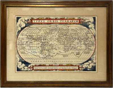
2023Early World Map "Typvs Orbis Terrarvm" Hand ColorDated 1590 near bottom legend box. Hand colored, with red and orange watercolor prominent in the titles. Blue clouds in border. Some slight use of yellow in the boundaries of the map. With signature oSee Sold Price
Sold20231861 Hagar Geology of Vermont 2 vols1861 Albert D Hager "Report of the Geology of Vermont" (2 vols), 1st edition with fold-out maps, charts, some in color, appears complete (not collated), rebound in cream colored cloth, some loose pageSee Sold Price
Sold2023Group of 14 Ireland County MapsGroup of 14 early 20th century Ireland County maps, in partial color, including Cork, Donegal, Kerry, Dublin, Galway, and others. Provenance: Phyllis Lucas Gallery, NYC. [6 1/2" H x 9 3/4" W]. Light tSee Sold Price
Sold2023COLLECTION OF 2 FRAMED SINCLAIR OPALINE ADVERTISEMENTS.Collection of 2 C.1920's professionally framed Sinclair Opaline card stock advertisement and early road map. CONDITION: Lot 1; Has good color with areas of staining and browning to the white backgrounSee Sold Price
Sold2022July 8, 1775 PA Newspaper Accounts of Bunker HillAmerican Revolution July 8, 1775 "Pennsylvania Ledger..." Newspaper Featuring Accounts of the Historic Battle of Bunker Hill & More July 8, 1775-Dated Revolutionary War Newspaper, "The Pennsylvania LeSee Sold Price
Oct 12JM Hobby Supply and Railroad Artifact AuctionsColorado and Southern RY Annual Reports 1915-1943$10(1 bid)
Oct 12JM Hobby Supply and Railroad Artifact AuctionsChicago Burlington and Quincy RR Annual Reports 1921-1946$10
5 hrs LeftRichmond AuctionsRare Oilzum Motor Oils and Lubricants Auto Supplies DS Porcelain Flange Sign w/ Oswald$550(7 bids)
5 hrs LeftRichmond AuctionsCrown Furnaces Globe and Ranges Curved SS Porcelain Sign Pottstown PA$100(4 bids)
5 hrs LeftRichmond AuctionsScarce Phoenix Pure Paint SS Porcelain Sign w/ Native American Graphic$1,300(3 bids)
5 days LeftJasper52Italiae Nova Tabula. Italy. SEBASTIAN MÜNSTER 1572 old antique map plan chart$750
5 days LeftJasper52Hydrographical chart of the world… Wright/Mercator's Projection THOMSON 1817 map$260
Oct 18Rail & Road AuctionsEarly Northern Pacific Railroad and Oregon Railway & Navigation Co. Promotional Brochure w/ Map$30


![Group of 14 Ireland County Maps: Group of 14 early 20th century Ireland County maps, in partial color, including Cork, Donegal, Kerry, Dublin, Galway, and others. Provenance: Phyllis Lucas Gallery, NYC. [6 1/2" H x 9 3/4" W]. Light t](https://p1.liveauctioneers.com/1221/310017/167287163_1_x.jpg?height=310&quality=70&version=1702345350)


