Sold20201855 Colton Map of Michigan -- MichiganTitle: 1855 Colton Map of Michigan -- Michigan Cartographer: J Colton Year/Place: 1855, New York Size: 14.6 X 11.7 in. Description: This is a very nice map of the 'hand/five fingers' portion on MichigSee Sold Price
Sold20221855 Colton Map of Michigan -- MichiganTitle: 1855 Colton Map of Michigan -- Michigan Cartographer: J Colton Year/Place: 1855, New York Dimensions: 14.6 X 11.7 in. Description: This is a very nice map of the 'hand/five fingers' portion onSee Sold Price
Sold2022Vintage map of Wisconsin & Michigan, 1865Johnson and Ward’s dynamic layout showing both of these Great Lakes states. The map includes parts of four of the five Great Lakes. Railroads, roads, coastal features, rivers, lakes, mines, IndiSee Sold Price
Sold2023[PICTORIAL MAPS]. Five maps. Includes: GREEN, Mildred C. A ...[PICTORIAL MAPS]. Five maps. Includes: GREEN, Mildred C. A Romance Map of New Jersey. 1935. Buffalo: Whitney-Graham Company. Inc. Colorful pictorial map with small illustrations and explanations of NeSee Sold Price
Sold20202 Hand Colored Maps - MichiganTwo Gray's Atlas Maps on one sheet - Michigan & Lake Superior and the Northern Part of Michigan Depicts railroad lines, common roads, canals, topography, etc. Maps are on eaSee Sold Price
Sold20211854 Geological Map Michigan & Lake Superior"Geological map of the district between Keweenaw Bay and Chocolate River, Lake Superior, Michigan". J.W. Foster & J.D. Whitney, U.S. geologists. Section and diagram illustrating the geology of the regSee Sold Price
Sold20211858 OLD TINTED MAP, MICHIGAN & WISCONSIN, MITCHELL1858 OLD TINTED MAP, MICHIGAN & WISCONSIN, MITCHELL SCHOOL & FAMILY GEOGRAPHY 1858 OLD TINTED MAP, MICHIGAN & WISCONSIN, MITCHELL SCHOOL & FAMILY GEOGRAPHY Description 1858 Antique Map by S. AugustusSee Sold Price
Sold2020[Fine Binding] Merivale, Charles, History of the Romans[Fine Binding] Merivale, CharlesHistory of the Romans Under the EmpireLondon: Longmans, Green, and Co., 1872-74. In eight volumes. "New Edition". 8vo. Illustrated with six maps (five folding). ErrataSee Sold Price
Sold2017Group of Antique Hawaiian Territory Survey MapsGroup of Antique Hawaiian Territory Survey Maps, five total including: Maui County, Kahoolawe, Niihau and Molokai, color surveys by the Andrew B. Graham Co. of Washington D.C., dated 1897, largest 27"See Sold Price
Sold2017Tanner: Antique Map of Michigan, 1843Title/Content of Map: Michigan by Tanner Date Printed: 1843 Cartographer: based on the work of H.C. Tanner Material/Medium: Paper Size: 17" x 14" Hand colored engraved Map. From the first edition publSee Sold Price
Sold2020Michigan 1903Title/Content of Map: Michigan 1903 Date Printed: 1903 Material/Medium: Paper Size: approx 21x16 inches Peerless Atlas, Crowell Publishing Co. Ohio Reserve: $30.00 Shipping: Domestic: Flat-rate of $1See Sold Price
Sold2020Michigan, Wisconsin 1886Title/Content of Map: Michigan, Wisconsin 1886 Date Printed: 1886 Material/Medium: paper Size: approx 13.5x21 inches Additional Info: The People's Unrivaled Family Atlas of the World. People's PublishSee Sold Price
Sold2022Five Maps of NantucketFour of the island and one of Main Street, including one by Tony Sarg (German, 1880-1942) Frames loose. Sizes from 17"h x 20"w to 23"h x 34"w overallSee Sold Price
Sold2021(MICHIGAN.) Maps and Report . . . for Ascertaining the(MICHIGAN.) Maps and Report . . . for Ascertaining the Northern and Northwestern Boundary between the United States and Great Britain. 8 maps with hand-colored border in blue and red. 2 text leaves. FSee Sold Price
Sold2019Five Maps by Abraham Ortelius (1527-1598), Three "LaFive Maps by Abraham Ortelius (1527-1598), Three "La Florida Aue Tore Hieron Chiaues; Two Guastecan Reg," 1583, H.- 8 3/4 in., W.- 11 1/2 in., and H.- 17 1/2 in., W.- 11 in. (5 Pcs.)See Sold Price
Sold2021Asia.- Lizars (W.) and others. Five maps of China,Asia.- Lizars (W.) and others. Five maps of China, including Lizars' map of the mainland, Robert Wilkinson's 'China, Contains 15 Subject Provinces', 2 maps of mainlaind China by Fullarton & Co., and aSee Sold Price
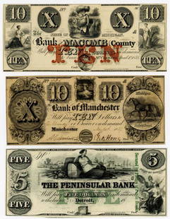
Sold2022FIVE MICHIGAN OBSOLETE CURRENCY NOTESGroup of four obsolete currency notes issued in Michigan. Group includes a two dollar note from the Farmers Bank of Sandstone dated January 8th, 1838, a Government Stock Bank two dollar note dated JulSee Sold Price
Sold2019Herman Moll, Five Maps of AsiaHeading: Author: Moll, Herman Title: Five maps of Asia Place Published: London Publisher:Printed for Tim. Childe Date Published: 1701 Description: Five maps. Each sheet appSee Sold Price
Sold2023Lovely vintage pre-Civil War RR map of MichiganFascinating, highly detailed map of Michigan with original full hand-coloring. Cowperthwait produced some of the most attractive state maps of the period and this one is particularly nice. PositionedSee Sold Price
Sold2023Group of Five MapsGroup of Five Maps, to include a new map of ancient Greece Thrace by William; Sweden; East Nottingham; Ireland; along with South Eastern Greece Attica Megorica Corinthiaca engraved map; largest 15" xSee Sold Price
Sold2022Three Railroad and City Maps - Chicago, Michigan, Toledo, OhioGroup of three railroad and city maps. Includes 1875 O.W Gray and Sons Railroad Map of Michigan measuring 17" x 24", unmarked early map of Chicago measuring 17 1/2" x 21 1/2", and 1920 Wagners DirectoSee Sold Price
Sold2022Maps of Michigan Lansing and Milford TopographyMaps of Michigan Lansing and Milford Topography These two maps we have are the surroundings of Lansing and Milford Michigan. these maps were made by surveys taken in 1907-1910. These maps show a detaiSee Sold Price
Sold2019Five Maps: consisting of two copies of Johnson & Ward,Five Maps: consisting of two copies of Johnson & Ward, "Lower and Upper Canada," 1860-1863, hand colored, H.- 26 1/2 in., W.- 18 1/8 in.; together with two copies of Johnson & Ward, "Lower Canada & NeSee Sold Price
Sold2019Five Maps by the Hydrographic Office U. S. Navy,Five Maps by the Hydrographic Office U. S. Navy, consisting of "England West Coast- Start Point to Needles Channel," 1933, H. -28 3/4 in., W. - 36 1/2 in.; "England East Coast- River Thames Entrance,See Sold Price
4 days LeftRail & Road AuctionsNine United Air Lines Paper Items - Travel Brochures, Guides, Maps, Information Packet, Flight Log,$30
21 hrs LeftJasper521660 HISTORY of the WORLD by WALTER RALEIGH antique ILLUSTRATED w/ MAPS English$700
5 days LeftActivity Auctions1879 Five Great Monarchies Ancient Eastern World Chaldea Assyria Babylon Persia 3 Vol. Set$900
3 days LeftHunt and Peck Estate Services, Inc.Stefano Della Bella "Death Dragging an Old Man To His Tomb"$100
22 hrs LeftJasper521756 Acapulco coastline, Mexico, depicted by the English pirate G. Anson.$20(1 bid)
Featured22 hrs LeftJasper521575 Braun and Hogenberg View of Northen France's Hesdin -- Hesdinum Oppidum et Castrum?$80


![[PICTORIAL MAPS]. Five maps. Includes: GREEN, Mildred C. A ...: [PICTORIAL MAPS]. Five maps. Includes: GREEN, Mildred C. A Romance Map of New Jersey. 1935. Buffalo: Whitney-Graham Company. Inc. Colorful pictorial map with small illustrations and explanations of Ne](https://p1.liveauctioneers.com/928/305275/163151900_1_x.jpg?height=310&quality=70&version=1697054833)


![[Fine Binding] Merivale, Charles, History of the Romans: [Fine Binding] Merivale, CharlesHistory of the Romans Under the EmpireLondon: Longmans, Green, and Co., 1872-74. In eight volumes. "New Edition". 8vo. Illustrated with six maps (five folding). Errata](https://p1.liveauctioneers.com/65/173390/87296690_1_x.jpg?height=310&quality=70&version=1594158866)