Sold2022Hand Colored Civil War Map on Foolscap by Major GriffithAuthentic hand colored map on foolscap paper of the campaign in the west in the Civil War by Major Griffith. delicate cond.See Sold Price
Sold2022Civil War Hand Drawn Map by Major Griffith Cumberland RiverHand drawn Civil War map by major Griffith of Pennsylvania showing the area between the Cumberland and Duck RiversSee Sold Price
Sold2022County Map of California, Mitchell 1860Lovely hand-colored map of California during the Civil War era. One of the earliest maps of California to appear in an American Atlas. Shows California divided into counties, showing all major towns aSee Sold Price
Sold202319th century. A hand-colored American Civil War era map of Virginia, Delaware, Maryland, and West19th century. A hand-colored American Civil War era map of Virginia, Delaware, Maryland, and West Virginia. Published by A.J. Johnson New York USA. Marked as page 47. Overall good condition; some browSee Sold Price
Sold2022JOHN TALLIS (1817-1876) AN AMERICAN CIVIL WAR MAP, "United States," LONDON, CIRCA 1863,JOHN TALLIS (1817-1876) AN AMERICAN CIVIL WAR MAP, "United States," LONDON, CIRCA 1863, hand-colored lithograph on wove paper showing, "Federal, Non Slave Holding States (Red); Border, Slaveholding (BSee Sold Price
Sold2017Young: Antique Pre Civil War Map of Virginia, 1851Title/Content of Map: Pre Civil War rare Tourist Map of Virginia Date Printed: 1851-1859 Cartographer: J. Young Material/Medium: Paper Size: 16" x 13 1/2" Condition: Excellent Hand colored. A rare PocSee Sold Price
Sold2017Colton: Antique Pre Civil War Map South Carolina, 1861Title/Content of Map: Pre Civil War South Carolina by Colton Date Printed: 1861 Cartographer: J.H. Colton Material/Medium: Paper Size: 17 1/2" x 14" Hand colored steel engraved Map from 'Colton's GeneSee Sold Price
Sold20221846 Pre civil war middle states. By MitchellTitle: 1846 Pre civil war middle states. By Mitchell Date/Period: 1846 Materials: Hand colored engraved Size: 11 1/2 x 17 1/2" Pre civil war maps shows New York, New Jersey, Pennsylvania, Delaware, MaSee Sold Price
Sold20231842 MATHER & SMITH WALL MAP OF LONG ISLAND, NYHand-colored lithograph. "A Geological Map of Long & Staten Islands with the Environs of New York"; William W. Mather, geologist and J. Calvin Smith, surveyor. This landmark pre-Civil War map is the eSee Sold Price
Sold2022AN AMERICAN CIVIL WAR ERA MAP, "United States of North America (Eastern & Central)," LONDON,AN AMERICAN CIVIL WAR ERA MAP, "United States of North America (Eastern & Central)," LONDON, 1861-1873, THEODORE ETTLING (b. 1823), hand colored lithograph on paper, by T. Ettling, published by CasselSee Sold Price
Sold2023Civil War era map of Florida, 1863Lovely early map of Florida, vividly hand colored by county, with a large inset of the Florida Keys. Shows towns, railroads, villages, post offices, forts, etc. Only five counties shown in the southerSee Sold Price
Sold2015Fisk & Russell Scarce Civil War Pocket MapThis circa 1862 hand colored folded pocket map was printed by Fisk & Russell, N.Y., no date or title but shows most of the U.S. and southern Canada with small inset map of ‘Eastern Part of MassaSee Sold Price
Sold2022SAMUEL AUGUSTUS MITCHELL JR., AN AMERICAN CIVIL WAR ERASAMUEL AUGUSTUS MITCHELL JR., AN AMERICAN CIVIL WAR ERA MAP, "County Map of Texas," CIRCA 1863, hand-colored lithograph on paper with profusely floral and fruit border, plate 34. from Mitchell's New GSee Sold Price
Sold2022Significant United States map, 1864 Johnson & WardVery interesting hand-colored map created at a pivotal time in the settlement of the American West. In this lovely Civil War era map many of the western states have still not settled their borders. ArSee Sold Price
Sold2022Louisiana & Alabama with Mississippi, 1864 scarce publication by SchonbergTitle: Louisiana & Alabama with Mississippi, 1864 scarce publication by Schonberg Date/Period: 1864 Materials: Hand colored steel plate engraved. Size: 14 x 12 inches 1864 uncommon civil war era map bSee Sold Price
Sold2022Title page of Schonberg’s 1864 atlas, 1864 scarce publication by SchonbergTitle: Title page of Schonberg’s 1864 atlas, 1864 scarce publication by Schonberg Date/Period: 1864 Materials: Hand colored steel engraved Size: 14 x 12'' 1864 uncommon civil war era map by SchoSee Sold Price
Sold2022llinois & Ohio with Indiana, 1864 scarce publication by SchonbergTitle: llinois & Ohio with Indiana, 1864 scarce publication by Schonberg Date/Period: 1864 Materials: Hand colored steel plate engraved. Size: 14 x 12 inches 1864 uncommon civil war era map by SchonbeSee Sold Price
Sold2022Germany & Austrian Empire 1864. Scarce publication by SchonbergTitle: Germany & Austrian Empire 1864. Scarce publication by Schonberg Date/Period: 1864 Materials: Hand colored steel engraved Size: 14 x 12'' 1864 uncommon civil war era map by Schonberg, New York.See Sold Price
Sold2022Prussia with Saxony & Switzerland 1864. Scarce publication by SchonbergTitle: Prussia with Saxony & Switzerland 1864. Scarce publication by Schonberg Date/Period: 1864 Materials: Hand colored steel engraved Size: 14 x 12 inches 1864 uncommon civil war era map by SchonberSee Sold Price
Sold2018Pre Civil War South Carolina Map Charleston 1847Original hand colored map in overall good condition. Not a repro or restrike. Recently matted and framed using conservation materials. Framed dimensions 23 x 19 inches.See Sold Price
Sold2022(CIVIL WAR.) P.S. Duval & Son. Military Map of the United States & Territories(CIVIL WAR.) P.S. Duval & Son. Military Map of the United States & Territories Showing the Location of the Military Posts, Arsenals, Navy Yards, & Ports of Entry. Hand-colored lithographed pocket mapSee Sold Price
Sold20231862 Civil War, Coltons New Topographical Map of The States of Virginia, Maryland and DelawareHistoric Maps 1862 Civil War "Colton's New Topographical Map of The States of Virginia, Maryland and Delaware" Hardcover Folio 1862-Dated Civil War Period, Hand-colored 45.25" x 31.5" Folding Map titlSee Sold Price
Sold2017Johnson’s Civil War era map of North & South CarolinaHistoric map shows the Carolinas in great detail shortly following the outbreak of the Civil War. States hand-colored at the time of publishing with color coding according to county. Inset map depictsSee Sold Price
Sold2022Two 1867 Maps of "The Lost Cause", Highlighting Military Operations of the Civil WarTwo 1867 Maps of "The Lost Cause", Highlighting Military Operations of the Civil War A pair of hand-colored maps of "The Lost Cause: Map of the Military Operations During the War of 1861-1865." MeasurSee Sold Price
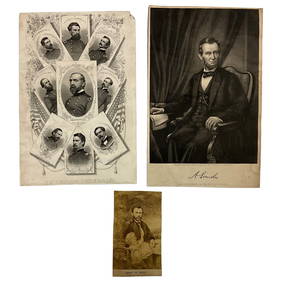
3 days LeftLakeshore Event CenterEphemera, Civil War Generals, Abraham Lincoln, Ulysses Grant, Lot of 3$62(2 bids)
4 days LeftSchilb Antiquarian Rare Books1918 Robert E Lee Civil WAR Confederate General CSA Battles MAPS Illustrated$48(5 bids)
7 days LeftUniversity ArchivesAbraham Lincoln PSA GEM MT 10 CDV, Signed 3 Weeks Before His Death.$30,000(1 bid)
4 days LeftSchilb Antiquarian Rare Books1890 1ed Confederate Memoirs of Joseph Johnston & Jefferson Davis Civil War CSA$66(3 bids)
Jul 07Case Antiques, Inc. Auctions & Appraisals3 Civil War Era Photos, incl. Rose O'Neal Greenhow, poss. Jeff Davis$150
7 days LeftUniversity ArchivesCapture of Jefferson Davis: “Mr. Davis tried to escape…with a ladies waterproof$1,600
Jul 14Schilb Antiquarian Rare Books1928 Life of Abraham Lincoln 1ed SLAVERY Civil War Albert Beveridge 2v SET$1(1 bid)
Jul 04Weatherham Estate TreasuresAbraham Lincoln Bronze Bust Sculpture On Marble Base - Signed Original - 10lbs$400
Jul 06Case Antiques, Inc. Auctions & Appraisals7 Stephens and Davis CSA Items inc. ALS, Bust, CDVs and Seals$150(1 bid)
7 days LeftUniversity ArchivesBeardless Abraham Lincoln Hand-Colored Kellogg Lithograph Used During 1860 Convention & Campaign$100
Jul 14Schilb Antiquarian Rare Books1885 Civil War 1ed Memoirs of Union General Ulysses S. Grant Illustrated MAPS 2v$125(6 bids)
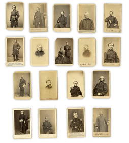
7 days LeftUniversity Archives18 pc. CDV Archive of Civil War Generals Incl. Many Brady & E. Anthony Examples$260(1 bid)
Jul 06Case Antiques, Inc. Auctions & AppraisalsCivil War Veteran GAR Uniform, PVT Stephen F. Oliver$200(1 bid)
7 days LeftUniversity ArchivesIconic U.S. Grant Battlefield Albumen by Mathew Brady at City Point During Siege of Petersburg$400
4 days LeftSchilb Antiquarian Rare Books1860 Political Textbook 1ed SLAVERY Abe Lincoln Douglass Civil War Government$74(4 bids)
Jun 28South Florida Auction & Estate Sale Services IncABRAHAM LINCOLN Memorial Belt Buckle Approved by MRS. LINCOLN$22(2 bids)
Jun 28South Florida Auction & Estate Sale Services IncCivil War Abraham Lincoln Tin Type Photograph$8(2 bids)