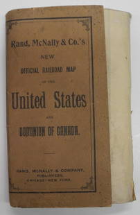
Sold2024Rand, McNally & Co.'S New Official Railroad Map of the United States And Dominion of CanadaTitle:Rand, McNally & Co.'S New Official Railroad Map of the United States And Dominion of Canada Publication Date: 1903 Cartographer:RAND, MCNALLY & CO. Publisher: RAND, MCNALLY & CO. Height: 30 WidtSee Sold Price
Sold2020AN ANTIQUE MAP, "New Railroad Map of the United States,AN ANTIQUE MAP, "New Railroad Map of the United States, the Dominion of Canada, Mexico and the West Indies," CHICAGO, CIRCA 1875, hand-colored lithograph on paper, publishing, engraving, and printingSee Sold Price
Sold2023New Railroad Map of the United States and the Dominion of CanadaPublication Date: 1876 Title: New Railroad Map of the United States and the Dominion of Canada Cartographer: Publisher: BASKIN, FORSTER & CO. Height: 16.25 Width: 26 From their Illustrated HistoricalSee Sold Price
Sold20201862 Colton Map of the United States -- Colton's NewTitle/Content of Map: 1862 Colton Map of the United States -- Colton's New Railroad & County Map of the United States the Canadas &c. Cartographer: J Colton Year/Place: 1862, New York Size: 33.1 X 39See Sold Price
Sold2019Rand McNally & Co.'s New Railroad and County Map of theTitle/Content of Map: Rand McNally & Co.'s New Railroad and County Map of the United States And Dominion of Canada Date: 1882 Cartographer: RAND, MCNALLY & CO. Publisher: RAND, MCNALLY & CO. Size: 26.See Sold Price
Sold20213 Pcs Railroad Ephemera incl MapsIncludes 1867 Map of the Railroad of the State of New York, General Railroad Map of the United States and Canada and a Railroad Man's Prayer. IMPORTANT: Before bidding, please read the terms and condiSee Sold Price
Sold2024Rand, McNally & Co.'S New Commercial Railroad Map of the United States [Chicago to Denver]Title: Rand, McNally & Co.'S New Commercial Railroad Map of the United States [Chicago to Denver] Cartographer: RAND, MCNALLY & CO. Publisher: RAND-MCNALLY & CO. Dimensions: Height: 26 Width: 18.5 DesSee Sold Price
Sold2017J.T. Lloyd Wall Map of U.S. & Canada"Lloyds New Map of the United States, the Canadas and New Brunswick" dated 1863. 39" high, 57 1/2" wide. Toned throughout, scattered edge losses and small tears, tear with old tape repair upper left,See Sold Price
Sold20231893 Civil War Map of the South -- Section of G. Woolworth Colton's New Guide Map of the UnitedTitle: 1893 Civil War Map of the South -- Section of G. Woolworth Colton's New Guide Map of the United States and Canada with Railorads, Counties, etc. 1863. Used by General Grant in Marking the PropoSee Sold Price
Sold2021Colton Railroad and County Map United States 1878Colton, after G. W., Colton's Railroad and County Map of the United States, The Canadas, &c, 1878, antique map on paper, folded as originally issued, 33 x 42 inches, in a wood frame 36.5 x 47.5 inchesSee Sold Price
Sold2024Two Antique John Cary New Maps of Upper & Lower Canada and United States of AmericaTwo antique early 19thC. One map framed as shown. Map of the United States of America sheet measures approx. 19 1/2" x 22". Approx. image size 17 1/2" x 19 3/4". US map tear to upper left and lower leSee Sold Price
Sold2020Geological Map of the United States and Canada...Title: Geological Map of the United States and Canada... Publication Date: 1896 Cartographer: VON HISE, C.R. Publisher: U.S.G.S./A. Hoen & Co. Brief Description: "...Compiled from Official maps of theSee Sold Price
Sold2017SAMUEL DUNN HAND COLORED PRINTED MAPSAMUEL DUNN, HAND COLORED PRINTED MAP, IMAGE: H 19", W 12 1/2", "A NEW MAP OF THE UNITED STATES OF NORTH AMERICA":"--- with the British Dominions on the continent"; printed for Robert Sayer; framed.See Sold Price
Sold2021Railroad Map of the United States[America, East Coast] Ensign, Bridgman and Fanning's Railroad Map of the United States showing the Depots & Stations. Engraved map with original hand color. Engraved by W. S. Barnard. New York, 1856.See Sold Price
Sold2022(GOLD RUSH.) J.M. Atwood. Map of the United States, Canada, Mexico, Central America, and the West(GOLD RUSH.) J.M. Atwood. Map of the United States, Canada, Mexico, Central America, and the West India Islands with a Portion of Venezuela & New Granada; Showing the Routes Overland and by the IsthmuSee Sold Price
Sold2021ca. 1929 RAILROAD UNITED STATES MAP SHOWING NEW YORKVintage Railroad Map, "MAP of THE UNITED STATES SHOWING NEW YORK CENTRAL LINES". Map by Rand McNally and Co. Includes printed information on the reverse. Tiny text along bottom partly reads; "NY 4-29"See Sold Price
Sold2017A New Map of the States of Virginia North Carolina...and Georgia Comprehending the Spanish Provinces of East and West Florida Exhibiting the boundaries between the United States and Spanish Dominions as fixed by the Treaty of Peace in 1783 / CompiledSee Sold Price
Sold20171852 CROTONS MAP OF THE UNITED STATES & CANADASCOLTON, J[oseph] H[utchins]. Colton’s Map of the United States & Canadas. Routes are by Railroads, Stage-Roads, and Canals. Lithograph map with original color. Original red cover with gold gilt lettSee Sold Price
Sold20191886 RR Map of U. S. also shows Steamship linesVery clean, interesting and informative railroad map of the United States from Mitchell's 1887 New General Atlas, with important information on the late 19th century United States. Titled “RailroadSee Sold Price
Sold2024American Express/New York Central Railroad Map of the United States-1934This is a railroad map of the United States, as produced by the American Express Company, for distribution by the New York Central Railroad in 1934. New York Central lines are featured on this map, thSee Sold Price
Sold2017Vintage Paper W Canvas Map of USAroom Sized Vintage Paper W Canvas Map of USA. Reads as the 'New Map of That Portion of North America, Exhibiting the United States &Territories, The Canadas, New Brunswick, Nova Scotia, and Mexico, alSee Sold Price
Sold2023GEOGRAPHY MAP PUZZLES. 19TH CENTURY. 2 ITEMSMcLoughlin Bros (New York). DISSECTED MAP OF THE UNITED STATES * A NEW DISSECTED MAP OF THE UNITED STATES. N.d.; 1887. Colour-illustrated boxes. *Additional images and detailed condition reports are aSee Sold Price
Sold2020Ohman's New Relief Map of the United StatesTitle/Content of Map: Ohman's New Relief Map of the United States Cartographer: ALBERS Date: c1937 Publisher: THE OHMAN CO. Size: 22.5Height - 35.25Width "and adjoining portions of Canada and Mexico .See Sold Price
Sold2016BOOK-A NEW DICTIONARY OF AMERICANISMS BY SYLVA CLAPIN,BOOK-A NEW DICTIONARY OF AMERICANISMS BY SYLVA CLAPIN, 1902, BEING A GLOSSARY OF WORDS SUPPOSED TO BE PECULIAR TO THE UNITED STATES AND THE DOMINION OF CANADA, LOUIS WEISS & CO PUBLISHERS, SPINE, FRONSee Sold Price
9 hrs LeftJasper52Large Civil War map of the United States. ETTLING. Illustrated London News 1861$300
3 days LeftTrillium Antique Prints & Rare BooksKollner, Rare - Niagara Falls, Horseshoe Fall, from the Canada Side$200
Oct 12JM Hobby Supply and Railroad Artifact AuctionsLionel 1958 Railroad Map of the United States$20(1 bid)
Oct 12JM Hobby Supply and Railroad Artifact AuctionsChicago Burlington and Quincy RR 1921 United States Map$20(1 bid)
9 hrs LeftJasper52United States of America. California Gold region. THOMAS, COWPERTHWAIT 1852 map$380
Oct 18Rail & Road Auctions8' Pennsylvania Railroad "Look Out for the Locomotive" Cast Iron Crossing Sign$500(1 bid)
5 days LeftDonny Malone AuctionsSet 6 Signed Raul De Armas [Cuban Designer] KNOLL STUDIO 1991 Arm Chairs$100(1 bid)


![Rand, McNally & Co.'S New Commercial Railroad Map of the United States [Chicago to Denver]: Title: Rand, McNally & Co.'S New Commercial Railroad Map of the United States [Chicago to Denver] Cartographer: RAND, MCNALLY & CO. Publisher: RAND-MCNALLY & CO. Dimensions: Height: 26 Width: 18.5 Des](https://p1.liveauctioneers.com/5584/329422/177662153_1_x.jpg?height=310&quality=70&version=1715717898)


![Railroad Map of the United States: [America, East Coast] Ensign, Bridgman and Fanning's Railroad Map of the United States showing the Depots & Stations. Engraved map with original hand color. Engraved by W. S. Barnard. New York, 1856.](https://p1.liveauctioneers.com/1968/203922/103366115_1_x.jpg?height=310&quality=70&version=1620913733)


![1852 CROTONS MAP OF THE UNITED STATES & CANADAS: COLTON, J[oseph] H[utchins]. Colton’s Map of the United States & Canadas. Routes are by Railroads, Stage-Roads, and Canals. Lithograph map with original color. Original red cover with gold gilt lett](https://p1.liveauctioneers.com/4597/97465/50069280_1_x.jpg?height=310&quality=70&version=1482846039)


![[MAPS] DOUBLE-PAGE. LOT OF 4 SOLD TOGETHER (1 of 4)](https://p1.liveauctioneers.com/8124/343618/186530168_1_x.jpg?height=282&quality=70&version=1726178725)


![[MAPS] MISC CANADA/AMERICA. LOT OF 6 (1 of 6)](https://p1.liveauctioneers.com/8124/343618/186530170_1_x.jpg?height=282&quality=70&version=1726178725)


![Set 6 Signed Raul De Armas [Cuban Designer] KNOLL STUDIO 1991 Arm Chairs (1 of 20)](https://p1.liveauctioneers.com/3627/324939/174881888_1_x.jpg?height=282&quality=70&version=1726633739)


