Sold2021Moule, Thomas C1835 British Map. WarwickshireSteel Engraved Map Published C1835, London for "A Complete and Universal English Dictionary" by the Rev. James Barclay et al. Maps by Thomas Moule. Paper Size: 11 x 8.5 inch (28 x 22cm) Very minor marSee Sold Price
Sold2020Moule, Thomas C1838 British Map. WarwickshireSteel Engraved Map Published C1838 for "A Complete and Universal English Dictionary" by the Rev. James Barclay et al. Maps by Thomas Moule. Paper Size: 10.5 x 8 inch (27 x 21cm) Good ConditionSee Sold Price
Sold2022Moule, Thomas C1845 British Map. WarwickshireSteel Engraved Map Published C1845, London for "A Complete and Universal English Dictionary" by the Rev. James Barclay et al. Maps by Thomas Moule. Paper Size: 10.5 x 8 inch (27 x 21cm) Tight right maSee Sold Price
Sold2021Moule, Thomas C1840 British Map. WarwickshireSteel Engraved Map Published C1840, London for "A Complete and Universal English Dictionary" by the Rev. James Barclay et al. Maps by Thomas Moule. Paper Size: 11 x 8.5 inch (28 x 22cm) Good ConditionSee Sold Price
Sold2017Antique Framed English Map of WarwickshireAntique Framed English Map of Warwickshire, England. Framed and matted. Hand colored engraving. Measures 13.5 x 10.25 inches.See Sold Price
Sold2023Vintage Framed Map, City of Kingston NYhand colored map by Thomas Hunter; Burleigh Litho. Frame size: 28 1/4" high, 36 3/4" wide. Light toning, small stain.See Sold Price
Sold2022Early Map of Northamptonshire, EnglandEarly hand-colored comitatus map of Northamptonshire, England, surrounded by the counties of Leicestershire, Buckinghamshire, Warwickshire, Bedfordshire, etc., framed 21" x 23". Provenance: The CollecSee Sold Price
Sold2020Moule, Thomas C1850 British Maps (2) Warcks & Worcs"Warwickshire" and "Worcestershire" Steel Engraved Maps Published C1850 "A Complete and Universal English Dictionary" by the Rev. James Barclay et al. Maps by Thomas Moule. Paper Size: 10.5 x 8 inch (See Sold Price
Sold2022Thomas Gardner, English Hand Colored Road MapDepicting the roads from Exeter to Dorchester and from Plymouth to Dartmouth, inscribed to the honorable Nathaniel Napier, originally published in 1719. Nicely hand colored and framed. Sight size: 7"See Sold Price
Sold2020Early Hand Colored Map North America by T ConderAntique framed hand colored early map of North America. Top left image of Native man and foliage, reads "North America agreeable to the most approved Maps and Charts, by Thomas Condor" Frame: 14 3/4 iSee Sold Price
Sold2017Thomas Kitchin, Maryland and Scotland maps(Scottish, 1718-1784)., "Map of Maryland with the Delaware counties and the southern part of New Jersey," hand colored map, circa 1750, 7 x 9 in. , framed and "Scotland," circa 1760, 7 1/2 x 9 in. , fSee Sold Price
Sold2023MAP: NEW MAP OF ARKANSAS, STEAMBOAT ROUTES, 1854Framed map, "A New Map of Arkansas, with its Canals Roads & Distances," c.1854, published by Thomas, Cowperthwait & Company, No. 253 Market Street, Philadelphia, hand colored, includes steamboat routeSee Sold Price
Sold20211789 MAP OF SOUTH AMERICA BY THOMAS BOWEN1789 Hand colored An Accurate Map of South America from the Best Modern Maps and Charts by Thomas Bowen. Framed,23.5in x 18in. Good condition, some fold marks.See Sold Price
Sold2017The USA Map 1829, Engraving by W. Darton, London, UKThe United States of America, 1829 by W. Darton Junior, Holborn Hill. England. Hand colored engraved atlas map. Relief is shown pictorially. Map framed, matted and glazed. Publisher 1829, William DartSee Sold Price
Sold2021Thomas Kitchin Map of "South America"Thomas Kitchin (English, 1718-1784). "South America with its Several Divisions". A hand colored and engraved map with vertical central fold. 18" x 22" (sight), 26" x 29" (framed).See Sold Price
Sold2020Bowen, Emmanuel 1767 Hand Col Map of Staffordshire, UKHand Colored Copper Engraved Map Published 1767, London for "Atlas Anglicanus" by Thomas and Emmanuel Bowen. Paper Size: 14 x 9.5 inch (36 x 24cm) Very fragile paper. Heavy browning/toning. Tiny chipsSee Sold Price
Sold2020Kitchin, Thomas C1785 Hand Col Map of Staffordshire, UKHand Colored Copper Engraved Map Published C1785, London for "Bowles's Pocket Atlas of the Counties of South Britain or England and Wales" by Carrington Bowles. Maps by Thomas Kitchin. Folds as issuedSee Sold Price
Sold2020Kitchin, Thomas 1769 Hand Col Map of Staffordshire, UKHand Colored Copper Engraved Map Published 1769, London for "Kitchin's Pocket Atlas of England and Wales, Drawn to One Scale" by Thomas Kitchin. Centre fold as issued. Paper Size: 10 x 8 inch (25 x 20See Sold Price
Sold2024A framed 1850 Cowperthwait map of GeorgiaA framed, hand colored copy of A New Map of Georgia by Thomas, Cowperthwait & Co. of Philadelphia, published in 1850, and showing towns, roads, railroads, waterways and swamps. A list of steamboat rouSee Sold Price
Sold2021(2) Antique Italy Maps, Thomas Kitchin, C. SmithDescription These beautiful maps have both been hand colored and represent Italy. There is one published in London by Charles Smith, possibly early 1800s, framed and discolored from age, but still disSee Sold Price
Sold2022EARLY MAP "AMERICA"John Speede 1626, Thomas Bassett / Richard Chillwell, Abraham Goos; "The Description of America", hand colored, center fold, slight foxing, framed size 19" x 23 1/2", G-G+See Sold Price
Sold2022EARLY MAP OF BRITAINJohn Speede / Thomas Basett, bookplate "Sanon Heptarchy" on reverse, hand colored, center fold, slight toning, framed size 19" x 23 1/2", G-G+See Sold Price
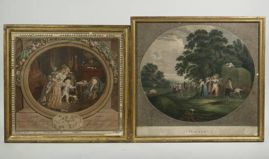
Sold2021(2) FRAMED EARLY PRINTSLot of (2) 18th and 19th c. European Prints, incl: "Summer" hand colored engraving depicting field workers, after a drawing by Thomas Hearne (UK, 1744-1817), engraved by W. Ellis, in a gilded wooden fSee Sold Price
Sold2017ANTIQUE MAP OF AFRICA, GERHARD MERCATOR JR.17TH CFramed engraved hand colored map, after 1600, by Gerhard Mercator Jr (his grandfather was Gerhard Mercator, Flemish, 1512-1594), "Africa Ex magna orbis terre descriptione Gerardi Mercatoris desumpta,See Sold Price
4 days LeftGrace Auction & Estate Gallery LLCAntique Hand Colored Map Bernardo Brognolo Veronae Vrbis Territorivm, Theatrum Orbis Terrarum$100
2 days LeftAlex CooperNicolas Visscher. "Orbis Terrarum Tabula Recens Emendata et in Lucem Edita Per N. Visscher,"$400
3 days LeftLink Auction GalleriesJohannes Kip, Dutch (1653-1722), Sandywell, the Seat of Henry Bret, Esq., and The Abbey in the Seat$300
23 hrs LeftLeland LittleRobert de Vaugondy's 18th-Century French Map of North America's Eastern Seaboard$50
3 days LeftTrillium Antique Prints & Rare BooksHamilton - 4 Engravings of a Painting from a Grecian Vase$100
Oct 13Winter Park GalleryAntique Biblia Latina framed Leaf - Biblical Latin hand colored framed sheet of bible$100