Sold2024Blaeu, pub. 1635 - Map of Romania: TransylvaniaThis remarkable, map with original hand-coloring is is Jan Blaeu's Le Theatre du Monde ou Nouvel Atlas Contenant, Les Chartes et Descriptions de tous les Pais de la Terre Mis en lumiere. This is fromSee Sold Price
2023Blaeu, pub. 1635 - Map of Scandinavia (Norway, Finland, Sweden)This remarkable, map with original hand-coloring is is Jan Blaeu's Le Theatre du Monde ou Nouvel Atlas Contenant, Les Chartes et Descriptions de tous les Pais de la Terre Mis en lumiere. This is fromSee Sold Price
Sold2017Bellin: Antique Map of Maluku Islands, Indonesia, 1757Title/Content of Map: 'Carte Particuliere des Isles Moluques. ' Maluku Islands - Halmahera - Ternate - Pulau Tidore - Makian Island - Bacan - Palamea Date Printed: 1757 Image Size: Approx 23.5 x 16.5cSee Sold Price
Sold2016Spice Islands Indonesia/ Moluccas, 1636Map Title: Insularum Moluccarum Nova descriptio (The Fabled Spice Islands Indonesia/ Moluccas) Published: Hondius, H./ Jansson, J., Amsterdam Date: 1636 Size: 15 x 19 1/2 inches (engraved surface exclSee Sold Price
Sold2019Bellin: Spice Islands (Moluccas), IndonesiaMap Title: Carte Particuliere des Isles Moluques Cartographer: Bellin Place / Date: Paris / 1752/1760 Size: 6" x 8 1/2" Condition: b&w; light overall age toning; map mounted on contemporary paper to fSee Sold Price
Sold2019Isles Philippines, Célèbes & Moluques'. East Indies.TITLE/CONTENT OF MAP: 'Carte des Isle Philippines, Célèbes, & Moluques [Map of the Philippines, Sulawesi, and the Maluku Islands]' Philippines, Borneo, Sulawesi, Moluccas / Maluku & Lesser Sunda IslSee Sold Price
Sold2021Stanford (Pub) 1894 Lot of 9 Maps of Asia East IndiesIncl Celebes, Sumatra, Borneo, Java, Philippines, Stations of Government Officials in the East Indies, Volcanic System of Malaysia, Moluccas, and Sunda Islands. Lithograph Maps Published 1894 by EdwarSee Sold Price
Sold2021Blaeu 1635 Map of Tartaria (Northern Asia)Finely engraved map by cartographer Blaeu depicting Tartaria, a term used for Central and Northern Asia. This map includes knowledge of English and Dutch explorers through Greek classics, such as mythSee Sold Price
Sold2021Blaeu 1635 Map of Tartaria (Northern Asia)Finely engraved map by cartographer Blaeu depicting Tartaria, a term used for Central and Northern Asia. This map includes knowledge of English and Dutch explorers through Greek classics, such as mythSee Sold Price
Sold2019CERTIFIED 8.44 GRAMS MALUKU ISLAND PEARL PENDANTNATURAL CERTIFIED 8.44 GRAMS MALUKU ISLAND PEARL PENDANT FROM THE MALUKU ISLANDS IN INDONESIA NON TREATED SOUTH SEA BEAUTY.HIGH LUSTER & THICK NACRE .HAS A WHITE TOPAZ ACCENT STONE.MEASURES 36.96 x 16See Sold Price
Sold2019NATURAL CERTIFIED MALUKU ISLAND PEARL PENDANTNATURAL CERTIFIED 7.98 GRAMS MALUKU ISLAND PEARL PENDANT FROM THE MALUKU ISLANDS IN INDONESIA NON TREATED SOUTH SEA BEAUTY.HIGH LUSTER & THICK NACRE .HAS A GOLD CITRINE ACCENT STONE.MEASURES 34.14 x 2See Sold Price
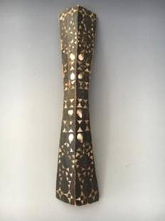
Sold2019African Wedding Dance Shield Ambon Island Maluku IslandAfrican Wedding Dance Shield Ambon Island Maluku Island Chain, Indonesia 19c Wood w/Shell inlay COA Provided 31H x 6W x 6L PICK UP IN NEW HAVEN, CT est value $100-300See Sold Price
Sold2018(1635) Blaeu Map: Mappa Aestivarvm Insularum,...Historic Maps Hand-Colored "Mappa Aestivarvm Insularum, alias Barmvdas dictarum..." by Willem J. Blaeu, Amsterdam (1635) Hand-Colored Historic Dutch Map titled: "Mappa Aestivarvm Insularum, alias BarmSee Sold Price
Sold20221649 Blaeu Map of the Spice Islands -- Moluccae Insulae CeleberrimaeTitle: 1649 Blaeu Map of the Spice Islands -- Moluccae Insulae Celeberrimae Cartographer: W Blaeu Year/Place: 1640, Amserdam Dimensions: 14.7 X 19.2 in. Description: This is an excellent map of IndoniSee Sold Price
Sold20181640 Blaeu Map of the Spice Islands -- Moluccae InsulaeTitle/Content of Map: 1640 Blaeu Map of the Spice Islands -- Moluccae Insulae Celeberrimae Date Printed: 1640 c., Amsterdam Cartographer: Hondius / Blaeu Size: 14.8 x 19.4 in. A very nice map of the SSee Sold Price
Sold2017Fimbiae Vulgo Femeren, Island Germany Map, Blaeu, 1667TITLE/CONTENT OF MAP: 'Fimbiae vulgo Femeren delineatio geometrica [Fimbiae commonly known as Fehmarn (Femern)]' Other places marked or shown on the map include Borg (Burg auf Fehmarn), Peterstorp (PeSee Sold Price
Sold2017Majorca, Minorca, & Ibiza Islands Map, Jansson, 1650Insulae Balearides et Pytiusae. Jansson's edition of Blaeu's beautiful map of the islands of Majorca, Minorca, and Ibiza, including the coasts of Catalonia and Valencia. As in Blaeu's version, sea monSee Sold Price
Sold202120th C. Indonesian Malaku Islands Ancestral Marker**Originally Listed At $1500** Southeast Asia, Indonesia, southeastern Malaku Islands (Moluccas / Spice Islands), ca. early 20th century CE. A massive carved wooden ancestral marker, made of two pieceSee Sold Price
Sold2024Ptolemy & Magini, pub. 1620 - Map of India and Surrounding Islands (East Indies)This early map engraving is from Claudius Ptolemaeus (Ptolemy) and Giovanni Antonio Magini's Geografia cio? Descrittione Universale della Terra Partita in due volumni, Nel Primo de' quali si contengonSee Sold Price
Sold2017Blaeu: Antique Map of the Moluccan Spice Islands, 1630Map: Moluccae Insulae Celeberrimae Cartographer: Willem Blaeu Place & Date: Amsterdam / 1630/1667 Size: 19 1/4" x 15" Condition: b & w. some light staining throughout; weakness along fold reinforced;See Sold Price
Sold2022Océanique. Partie de l'ile de Sumatra #18. West Sumatra. VANDERMAELEN 1827 mapTITLE/CONTENT OF MAP: Océanique - Partie de l'ile de Sumatra [Note sur l'île de Sumatra] - No. 18 Western Sumatra, Siberut and the Mentawai Islands, Indonesia DATE PRINTED: 1827 IMAGE SIZE:See Sold Price
Sold2016Blaeu, W.: Walachia, Servia, Bulgaria, Romania Map 1635Map: Walachia, Servia, Bulgaria, Romania Publishing: Blaeu, W.: Amsterdam Date: 1635 Size: 15 x 20 inches Early edition of a very attractive map of the Balkans, shown during the occupation by the OttoSee Sold Price
Sold20241635 Blaeu Caerte Van De Scher-meercolored map of the polder Schermer near Alkmaar, showing the dykes, roads and waters, with decorative cartouche and the coat-of-arms of Scherm-meerSee Sold Price
Sold2018Channel Islands of jersey & Guernsey 1659 by J. Blaeu.Title/Content of Map: Channel Islands of jersey & Guernsey 1659 by J. Blaeu. Amsterdam. 21 x 24 1/2”. Please note that this lot has a confidential reserve. When you leave a bid in advance of the aucSee Sold Price
Featured4 days LeftJasper521659 Blaeu Map of Southern Norway -- Dioecesis Stavangriensis, & Partes Aliquot Vicinae, Opera L.$200
4 days LeftJasper521640 Blaeu/Pijnacker Map of Northern Netherlands -- Drentia Comitatus. Transiselaniae Tabula II$240
5 days LeftJasper52HAWAII HISPANIOLA. Hawaiian Isles; Haiti San Domingo Dominican Republic 1898 map$20
Jun 29Trillium Antique Prints & Rare BooksCarey, pub. 1805 - 3 Maps of the States of Massachusetts, Connecticut, & New Jersey$75(1 bid)
5 days LeftJasper52WEST INDIES Caribbean Windward Leeward Islands Barbados Pirates? MALLET 1683 map$240
5 days LeftJasper52Windward or South Caribbean Islands. Barbados St. Lucia Trinidad. LOWRY 1860 map$55(1 bid)
5 days LeftJasper52Leeward Islands. Cuba, Hayti/Haiti or Santo Domingo, Puerto Rico. LOWRY 1859 map$110
5 days LeftJasper52Puerto Rico & Virgin Islands. Haiti, Hispaniola or St. Domingo. THOMSON 1817 map$140


![Isles Philippines, Célèbes & Moluques'. East Indies.: TITLE/CONTENT OF MAP: 'Carte des Isle Philippines, Célèbes, & Moluques [Map of the Philippines, Sulawesi, and the Maluku Islands]' Philippines, Borneo, Sulawesi, Moluccas / Maluku & Lesser Sunda Isl](https://p1.liveauctioneers.com/5584/139429/70692793_1_x.jpg?height=310&quality=70&version=1554845662)


![Fimbiae Vulgo Femeren, Island Germany Map, Blaeu, 1667: TITLE/CONTENT OF MAP: 'Fimbiae vulgo Femeren delineatio geometrica [Fimbiae commonly known as Fehmarn (Femern)]' Other places marked or shown on the map include Borg (Burg auf Fehmarn), Peterstorp (Pe](https://p1.liveauctioneers.com/5584/102908/52607369_1_x.jpg?height=310&quality=70&version=1492721880)


![Océanique. Partie de l'ile de Sumatra #18. West Sumatra. VANDERMAELEN 1827 map: TITLE/CONTENT OF MAP: Océanique - Partie de l'ile de Sumatra [Note sur l'île de Sumatra] - No. 18 Western Sumatra, Siberut and the Mentawai Islands, Indonesia DATE PRINTED: 1827 IMAGE SIZE:](https://p1.liveauctioneers.com/5584/264830/138097484_1_x.jpg?height=310&quality=70&version=1666125289)


