Sold2021Guthrie, William 1798 Map. ScotlandCopper Engraved Map Published 1798, London for "A New Geographical, Historical and Commercial Grammar..." by William Guthrie. The maps are by John Senex, Thomas Kitchin and others. Folds as issued. PaSee Sold Price
Sold2021Guthrie, William 1806 Map. ScotlandCopper Engraved Map Published 1806, London for "A New Geographical, Historical and Commercial Grammar..." by William Guthrie. The maps are by John Senex, Thomas Kitchin and others. Folds as issued. PaSee Sold Price
Sold2022Guthrie, William 1812 Map. ScotlandCopper Engraved Map Published 1812, London for "A New Geographical, Historical and Commercial Grammar..." by William Guthrie. Folds as issued. Paper Size: 10.5 x 8 inch (27 x 21cm) Approx. Some toningSee Sold Price
Sold2022Guthrie, William 1805 Map. ScotlandCopper Engraved Map Published 1805, London for "A New Geographical, Historical and Commercial Grammar..." by William Guthrie. Folds as issued. Paper Size: 10.5 x 8 inch (27 x 21cm) Approx. Some toningSee Sold Price
Sold2021Scarce c1610 map of Scotland, Wm. HoleFirst map of Scotland made by an Englishman in England. Fine map of Scotland engraved by William Hole (one of the earliest English engravers) for the first illustrated edition of Camden’s Britannia,See Sold Price
Sold2021Guthrie, William 1790 Antique Map. ScotlandCopper Engraved Map Published 1790, London for "A New Geographical, Historical and Commercial Grammar..." by William Guthrie. The maps are by John Senex, Thomas Kitchin and others. Folds as issued. EaSee Sold Price
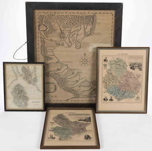
Sold2023ASSORTED EUROPEAN AND ASIAN MAPS, LOT OF FOURASSORTED EUROPEAN AND ASIAN MAPS, LOT OF FOUR, engraving on paper, three with hand-coloring, comprising a map of Buteshire in Scotland by William Home Lizars (Scottish, 1788-1859), two "LA FRANCESee Sold Price
Sold2016[Map] Seale, Richard. Map of North AmericaSeale, Richard William. A Map of North America with the European Settlements & Whatever Else is Remarkable in ye West Indies.... [London, c.1745.] Sheet measuring 505mm x 408mm. Rather toned, 2" closeSee Sold Price
Sold2022Swire, William 1825 Large Canal & River Map of the UK"Map of the Canals and Navigable Rivers in England, Wales and Scotland" Copper Engraved Map Published 1824-25, Liverpool for "History, Directory, and Gazetteer, of the County Palatine of Lancaster" bySee Sold Price
Sold20201800 The British Tourist Six Vol Set MapsThe British Tourist or Traveller's Pocket Companion Through England, Wales, Scotland, and Ireland.., by William Mavor, printed at London for E. Newberry (others) 1800. Three volumes with folding mapsSee Sold Price
Sold2022Hughes, William C1865 Lot of 4 European MapsIncl Europe, Ireland, Baltic and Scotland. Steel Engraved Maps Published C1865 London for "The History of England..." By David Hume, Tobias Smollett and others. Drawn and Engraved by William Hughes. CSee Sold Price
Sold20241897 History of British Empire England Scotland Canada James II MAPS India 6v1897 History of British Empire England Scotland Canada James II MAPS India 6v Edgar Sandersons “British Empire in the 19th-century” is a rare history of Great Britain, focusing on the progressSee Sold Price
Sold2019Richard William Seale (1732-1775), "Foldable 3 Map SetRichard William Seale (1732-1775), "Foldable 3 Map Set of England, Ireland, and Scotland," 1750, paper on linen, Each.- H.- W. - 46 in. (3 Pcs.)See Sold Price
Sold2019Richard William Seale (1732-1775, London), "A map ofRichard William Seale (1732-1775, London), "A map of North America with the European Settlements...West Indies," c. 1745, H. - 15 7/8 in., W. - 120 3/8 in.See Sold Price
Sold2022Map of United Kingdom, Circa 1833Map of United Kingdom of England, Scotland and Ireland. Published June 1833, engraved by William Darton, London. As is, condition commensurate with age. Size: 11 x 13 in. Location U1 CREAM BOXSee Sold Price
Sold2022National Encyclopedia 1891 Lot of 5 British MapsIncl Scotland, England, Geology, Tides etc. Lithograph Maps Published 1891-1901 by William Mackenzie, London for "The National Encyclopedia: A dictionary of Universal Knowledge" Center fold as issued.See Sold Price
Sold2016JOHN MELISH (SCOTLAND/AMERICAN 1771-1822), EARLY ANDJOHN MELISH (SCOTLAND/AMERICAN 1771-1822), EARLY AND RARE MAP OF THE UNITED STATES OF AMERICA, C.1813. ENTERED AS THE ACT DIRECTS AND PUBLISHED BY JOHN MELISH, PHILADELPHIA, JUNE 1813. SIGHT 13 X 17 1See Sold Price
Sold2021FADEN'S MAP OF GREAT BRITAIN, 1795, FRAMEDFolding Pocket Map, "The Roads of Great Britain" by William Faden, Geographer to the King, 1795, with Supplement for the Roads of Scotland. Linen backed five by four fold, in black frame with gold linSee Sold Price
Sold2020New and Complete Map of Scotland, And Islands TheretoTitle/Content of Map: New and Complete Map of Scotland, And Islands Thereto Belonging; Cartographer: Date: 1779 Publisher: ROBT. SAYER Size: 46.7Height - 39.7Width "from actual surveys, the Shires proSee Sold Price
Sold2019Maps 19th Cent. Mixed Lot of 6Lot of 6 Steel Engraved Maps. Incl Persia, Holy Land, Battle of Alma, Scotland, and England/Wales. Examples by Chambers, SDUK, William Collins, Weller and Rapkin. Paper Size: Up to 16 x 13.5 inch (40See Sold Price
Sold2024William Keith (1838 - 1911) American/ScotlandWilliam Keith (1838 - 1911) Oil on canvas, Signed Lower Right, Measures 18 x 22 and 24 x 28 inches w/frame. A native of Scotland, William Keith became in the late 19th and early 20th centuries a leadiSee Sold Price
Sold2022Engraved Copper Printing Blocks William Stirling-Maxwell. Don John of AustriaEngraved Copper Printing Blocks William Stirling-Maxwell. Don John of Austria 4 tin boxes and 3 oak boxes containing a large quantity of engraved printing blocks, chiefly the engraved copper printingSee Sold Price
Sold2022Stirling-Maxwell, Sir William (publisher) - Vesalius, Andreas Tabulae anatomicae sexStirling-Maxwell, Sir William (publisher) - Vesalius, Andreas Tabulae anatomicae sex Six anatomical tables. London: privately printed for Sir William Stirling-Maxwell, 1874. Large folio, engraved presSee Sold Price
Sold2022Stirling-Maxwell, Sir William (publisher) - Vesalius, Andreas Tabulae anatomicae sexStirling-Maxwell, Sir William (publisher) - Vesalius, Andreas Tabulae anatomicae sex Six Anatomical Tables of Andrew Vesalius. London: privately printed for Sir William Stirling-Maxwell, 1874. Large fSee Sold Price
Jun 30Brandywine Valley AuctionsRare Antique 17th Century William Beery English Map of Bavaria$25(1 bid)
5 hrs LeftSchilb Antiquarian Rare Books1848 Emory Military Reconnaissance 1ed California MAP Indians Texas New Mexico$105(8 bids)
Jul 06Case Antiques, Inc. Auctions & AppraisalsWilliam Hogarth, Marriage a la Mode, 6 Engravings plus Self-Portrait$200
2 days LeftLunds Auctioneers & Appraisers Ltd.Book & Map: "Some Account of the British Dominions Beyond the Atlantic", 1776, William DCA$550(2 bids)
Freeman's | Hindman[MAPS - LOUISIANA - WAR OF 1812]. Maps of Louisiana, incl. Battle of New Orleans battle site map.$150(1 bid)
4 days LeftJulien's AuctionsPrincess Diana | Catherine Walker The Chelsea Design Company Pleated Skirt With Book$10,000
5 hrs LeftSchilb Antiquarian Rare Books1884 Geology of VIRGINIA 1ed Appalachian Railroads HUGE MAPS Coal Barton Rogers$23(2 bids)
5 days LeftLeland LittleWilliam Prescott’s Classic Historical Works, Uniformly Leather Bound$50(1 bid)


![[Map] Seale, Richard. Map of North America: Seale, Richard William. A Map of North America with the European Settlements & Whatever Else is Remarkable in ye West Indies.... [London, c.1745.] Sheet measuring 505mm x 408mm. Rather toned, 2" close](https://p1.liveauctioneers.com/3532/91776/46880446_1_x.jpg?height=310&quality=70&version=1469669287)


![[Maps & Atlases] Speed, John: The Turkish Empire (1 of 2)](https://p1.liveauctioneers.com/65/332523/179335176_1_x.jpg?height=282&quality=70&version=1717709446)


![[MAPS - LOUISIANA - WAR OF 1812]. Maps of Louisiana, incl. Battle of New Orleans battle site map. (1 of 7)](https://p1.liveauctioneers.com/197/333931/180433328_1_x.jpg?height=282&quality=70&version=1718838007)


