Sold2024ASIA PHYSICAL. Relief Mountain heights Ocean depths Rivers. JOHNSTON 1897 mapTITLE/CONTENT OF MAP: 'The Mountains Table Lands Plains & Valleys of Asia' DATE PRINTED: 1897 IMAGE SIZE: Approx 21.5 x 26.0cm, 8.5 x 10.25 inches (Medium) TYPE: Antique colour map CONDITION: Good; suSee Sold Price
Sold2022ASIA PHYSICAL Relief Mountain heights Ocean depths Rivers JOHNSTON 1892 mapTITLE/CONTENT OF MAP: 'The Mountains, Table Lands, Plains & Valleys, of Asia' DATE PRINTED: 1892 IMAGE SIZE: Approx 21.5 x 26.0cm, 8.5 x 10.25 inches (Medium) TYPE: Antique colour map CONDITION: Good;See Sold Price
Sold2024ASIA PHYSICAL. Relief Mountain heights Ocean depths Rivers. JOHNSTON 1901 mapTITLE/CONTENT OF MAP: 'The Mountains, Table Lands, Plains & Valleys of Asia' DATE PRINTED: 1901 IMAGE SIZE: Approx 22.0 x 27.0cm, 8.5 x 10.5 inches (Medium) TYPE: Antique colour atlas map CONDITION: GSee Sold Price
Sold20231856 Johnston Map of the Americas' Geological Features -- The Physical Features of North & SouthTitle: 1856 Johnston Map of the Americas' Geological Features -- The Physical Features of North & South America, Showing the Mountains, Table-Lands, Plains, and Slopes Cartographer: AK Johnston Year /See Sold Price
Sold20246 Decorative Old Maps of 16th-18th CenturiesSet of six vintage "Decorative Old Maps of 16th, 17th, 18th Centuries" including colored maps of Europe, The Holy Land, Asia, Belgium, and Canada and the Great Lakes. [Sheets: 16" H x 20" W]. In goodSee Sold Price
Sold2024Asia (Physical). Elevation. Mountains 1907 old antique vintage map plan chartTITLE/CONTENT OF MAP: 'Asia (Physical)' DATE PRINTED: 1907 IMAGE SIZE: Approx 16.5 x 21.5cm, 6.5 x 8.25 inches (Medium); Please note that this is a folding map. TYPE: Vintage colour map CONDITION: GooSee Sold Price
Sold2024ASIA. Map of the Mountain Chains and the River systems of Asia 1881 oldTITLE/CONTENT OF MAP: 'Map of the Mountain Chains and the River systems of Asia' DATE PRINTED: 1881 IMAGE SIZE: Approx 24.0 x 32.0cm, 9.5 x 12.5 inches (Large); Please note that this is a folding map.See Sold Price
Sold2024Original 1723 Map of Asia by Guillaume Delisle.Original 1723 Map of Asia by Guillaume Delisle. 18th-C and colored with a date of 1745 at lwr L/S corner. Spans from Japan to Italy and Diego Garcia north to the Land of Jelmer. The most famous of theSee Sold Price
Sold2021Eadie, John 1863 Lot of 5 Holy Land MapsIncl Journeys of Apostle Paul/Asia Minor Apocalyptic Churches, Plan of Jerusalem, Journeys of the Children of Israel/Old & New Canaan, Judah & Israel/Land of Canaan, and The World as peopled by the deSee Sold Price
Sold2021Eadie, John 1864 Lot of 5 Holy Land MapsIncl Journeys of Apostle Paul/Asia Minor Apocalyptic Churches, Plan of Jerusalem, Journeys of the Children of Israel/Old & New Canaan, Judah & Israel/Land of Canaan, and The World as peopled by the deSee Sold Price
Sold2023TWO ANTIQUE MAPS OF CHINA.Two antique maps of China, including Chinae by Abraham Ortelius, 1595, image 14.25” x 18.25”, with map of Eastern Asia, Le table de la region orientale, image 10” x 13.5”.See Sold Price
Sold2022Exceptional map of Johnson's Texas, 1866Authentic and impressive vintage map of Texas. A highly desirable map that details the state in full. Shows the elevated Table Lands, the U. S. Mail Route, the Staked Plain (El Llando Estadado), numerSee Sold Price
Sold2023Sale & Psalmanazar C1740 Map. Garden of Eden & Plain of Shinaar, Holy Land"A Map of the most probable Place of the Garden of Eden, Plain of Shinaar, and Mountain where the Ark rested, according to this History" Copper Engraved Map Published 1736-44, London for "An UniversalSee Sold Price
Sold20221814 map of the Old World, WilkinsonExcellent map of the Old World titled “Terra Veteribus Nota” (Land of the Old) from An Atlas Of Ten Select Maps Of Ancient Geography Both Sacred And Profane; With A Chronological Table OfSee Sold Price
Sold2022Central Asia.- Ides (E. Ysbrants) Three Years Travel from Moscow over-land to China, first EnglishCentral Asia.- Ides (E. Ysbrants) Three Years Travel from Moscow over-land to China, first English edition, engraved additional title, folding engraved map (small hole at fold, tear at fold and anotheSee Sold Price
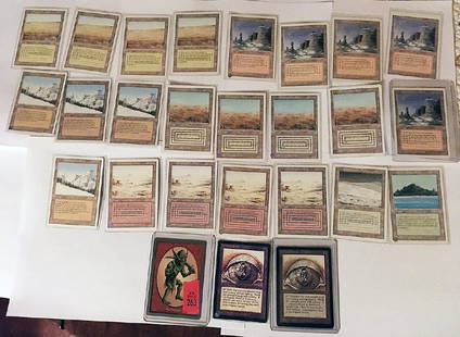
Sold201826 Rare MTG Cards26 Magic The Gather Cards including: 4 Savannah Cards, 3rd Edition/Revised, Land, Forest Plains, Artist: Rob Alexander. 5 Plateau Cards, 3rd Edition/Revised, Land, Mountain Plains, Artist: Cornelius BSee Sold Price
Sold2021Calif-Asia Wicker TableA large, round, Calif-Asia wicker table with red metal legs. 26.5 x 48.5. All measurements are in inches.See Sold Price
Sold2024Huge Indus Valley Bowl with Lions - TL testedCentral Asia, Indus Valley, Harappan / Mohenjo-Daro civilization, ca. 2300 to 1900 BCE. An incredible, large example of a terracotta bowl painted with black outlined motifs of striding lions around itSee Sold Price
Sold2017Mercator (Gerard) - Atlas sive Cosmographicae,Editio Quinta, engraved pictorial title, prelims, 49 double-page maps, including Asia, Russia, Turkey, Lithuania, Asia Minor and Persia, regions of Italy Spain, Germany and Eastern Europe, and 11 singSee Sold Price
Sold2021Calif-Asia Wicker Table & BenchesA three piece wicker table set by Calif-Asia. Removable legs. Bench: 15.5 x 61 x 13.5 / Table: 26.5 x 61 x 35. All measurements are in inches.See Sold Price
Sold2019BeshirMid 19th century, 264 x 147 cm, Central Asia, middle Amu Darya valley At each end of the red field covered in large arabesque palmettes and sickle leaves, a square with a yellow frame contains red snaSee Sold Price
Sold2023Ersari Main Carpetsecond half 19th century, 304 x 230 cm, Central Asia, middle Amu Darya valley A very large Ersari main carpet woven on a wool and goat hair warp. Three rows of seven octagonal gulli guls with floral sSee Sold Price
Sold2015De Bry (Theodore) - Descriptio Hydrographicathe 2-sheet map of Africa and Asia, from the east coast of Brazil to Japan, charting the first Dutch voyage to the East Indies by Houtman, large titlecartouche upper centre of right sheet, ships, compSee Sold Price
Sold2020Calif-Asia - Wicker Table & BenchesDescription - a table and bench set by Calif-Asia. Does not retain original label. Dimensions - Table - 26" x 60" x 35"See Sold Price
253 Lots AwayForum Auctionsd'Anville (Jean Baptiste Bourguignon) [Untitled Composite Atlas with 102 map sheets], [probably£2,000
Jun 11Quittenbaum Kunstauktionen GmbHGustav Gurschner, Figurative table light 'Die Verlassene', 1897€4,000
Jun 07Freeman's | HindmanCURRIER and IVES, publishers -- After Frances F. Palmer. The Rocky Mountains. Emigrants Crossing the$4,000
Jun 18DOYLE Auctioneers & AppraisersA block puzzle with maps of Europe, England, Ireland, Scotland, America and the World$100
5 days LeftDOYLE Auctioneers & AppraisersItalian Renaissance Walnut Dining Table Probably Genoa, 16th Century$1,000
Jun 07Freeman's | Hindman[MAP]. TODESCHI, Pietro. [Nova et Acurata Totius Americae Tabula auct. G.I. Blaeu] America quarta$5,000


![6 Decorative Old Maps of 16th-18th Centuries: Set of six vintage "Decorative Old Maps of 16th, 17th, 18th Centuries" including colored maps of Europe, The Holy Land, Asia, Belgium, and Canada and the Great Lakes. [Sheets: 16" H x 20" W]. In good](https://p1.liveauctioneers.com/1221/316726/170695118_1_x.jpg?height=310&quality=70&version=1706931805)


![d'Anville (Jean Baptiste Bourguignon) [Untitled Composite Atlas with 102 map sheets], [probably (1 of 3)](https://p1.liveauctioneers.com/5458/329231/177514974_1_x.jpg?height=282&quality=70&version=1715269091)


![[MAP]. TODESCHI, Pietro. [Nova et Acurata Totius Americae Tabula auct. G.I. Blaeu] America quarta (1 of 1)](https://p1.liveauctioneers.com/197/329395/177650542_1_x.jpg?height=282&quality=70&version=1715364962)
