


Similar Sale History
View More Items in Maps & Atlases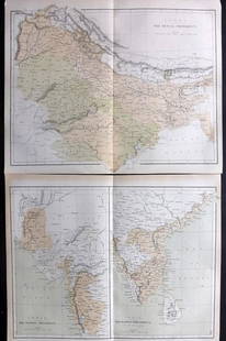


Item Details
Description
This is a map of India during the British Empire period, created in 1837 by Aristide Perrot. It was published in Paris and is part of the ?Dictionnaire Universal de Geographie Moderne, Description Physique, politique et Historique de Tours les Leux de la Terre’ collection. The map features hand-colored and copperplate engraved details. It measures 7 x 10 3/4?. Please note that the internal boundaries shown in the map may not be accurate. The map is in excellent condition and its authenticity is guaranteed.
Reserve: $60.00
Shipping:
Your purchase is protected:
Photos, descriptions, and estimates were prepared with the utmost care by a fully certified expert and appraiser. All items in this sale are guaranteed authentic.
In the rare event that the item did not conform to the lot description in the sale, Jasper52 specialists are here to help. Buyers may return the item for a full refund provided you notify Jasper52 within 5 days of receiving the item.
Condition
Excellent condition
Buyer's Premium
- 15%
1837 India, British Empire Map, By A. Perrot
$60.00
$80
Shipping & Pickup Options
Item located in New York, US$14 shipping in the US
Payment
Accepts seamless payments through LiveAuctioneers
See More Items From This Jasper52 Seller


![[MAP]. TODESCHI, Pietro. [Nova et Acurata Totius Americae Tabula auct. G.I. Blaeu] America quarta: [MAP]. TODESCHI, Pietro. [Nova et Acurata Totius Americae Tabula auct. G.I. Blaeu] America quarta pars orbis quam plerunq, nuvum orbem appellitant primo detecta est anno 1492 a Christophoro Columbo...](https://p1.liveauctioneers.com/197/329395/177650542_1_x.jpg?height=310&quality=70&version=1715364962)


![[MAPS]. HOMANN, Johann Baptist, HOMANN HEIRS, and Georg Matthäus SEUTTER. [Composite Atlas].: [MAPS]. HOMANN, Johann Baptist (1663-1724), HOMANN HEIRS, and Georg Matthäus SEUTTER (1678-1757). [Composite Atlas]. [Nuremberg, Augsburg, and others: Homann Heirs and others, maps dated between](https://p1.liveauctioneers.com/197/329395/177650530_1_x.jpg?height=310&quality=70&version=1715364962)


TOP