Sold2021Nolan, Edward C1880 Map of The East India IslandsSteel Engraved Map Published C1880, London for "The Illustrated History of the British Empire in India and the East" by Edward H. Nolan. Centre fold as issued. Paper Size: 12 x 10 inch (30 x 25cm) GooSee Sold Price
Sold2019Japan C1880 Pair of Maps by Nolan & Blackie"The Islands of Japan with Corea..." Steel Engraved Map Published C1880, London for "The Illustrated History of the British Empire in India and the East" by Edward H. Nolan. Centre fold as published.See Sold Price
Sold2019Nolan, Edward C1880 Map of The Eastern HemisphereSteel Engraved Map Published C1880, London for "The Illustrated History of the British Empire in India and the East" by Edward H. Nolan. Centre fold as published. Paper Size: 12.5 x 9.5 inch (32 x 24cSee Sold Price
Sold2021Nolan, Edward C1880 Map of Eastern HemisphereSteel Engraved Map Published C1880, London for "The Illustrated History of the British Empire in India and the East" by Edward H. Nolan. Centre fold as issued. Paper Size: 12 x 10 inch (30 x 25cm) SmaSee Sold Price
Sold2021Nolan, Edward C1880 Decorative Map of IndiaSteel Engraved Map Published C1880, London for "The Illustrated History of the British Empire in India and the East" by Edward H. Nolan. Centre fold as issued. Paper Size: 12 x 10 inch (30 x 25cm) GooSee Sold Price
Sold2021Nolan, Edward C1880 Lot of 3 Maps. China, Japan, AsiaSteel Engraved Map Published C1880, London for "The Illustrated History of the British Empire in India and the East" by Edward H. Nolan. Centre fold as issued. Paper Size: 12 x 10 inch (30 x 25cm) GooSee Sold Price
Sold2023Nolan & Hughes C1880 Antique Map. Eastern HemisphereLithograph Map Published C1880, London for "The Illustrated History of the British Empire in India and the East" by Edward H. Nolan. Centre fold as issued. Drawn by W. Hughes. Paper Size: 12 x 10 inchSee Sold Price
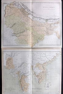
Sold2021Nolan, Edward C1880 Pair of Maps of India"India. The Bombay Presidency/India. The Madras Presidency" and "India The Bengal Presidency" Steel Engraved Map Published C1880, London for "The Illustrated History of the British Empire in India andSee Sold Price
Sold2019Nolan, Edward C1880 Lot of 6 Prints of IndiaSteel Engravings Published C1880, London for "The Illustrated History of the British Empire in India and the East" by Edward H. Nolan. Centre fold as published. Paper Size: 10 x 5 inch (25 x 16cm) VerSee Sold Price
Sold2021Nolan, Edward C1880 Lot of 8 India Related PortraitsSteel Engraving Published C1880, London for "The Illustrated History of the British Empire in India and the East" by Edward H. Nolan. Paper Size: 10 x 7 inch (25 x 18cm) Good Condition overallSee Sold Price
Sold2021Nolan, Edward C1880 Lot of 8 India Related PortraitsSteel Engraving Published C1880, London for "The Illustrated History of the British Empire in India and the East" by Edward H. Nolan. Paper Size: 10 x 7 inch (25 x 18cm) Good Condition overallSee Sold Price
Sold2023Nolan, Edward C1880 Lot of 9 Views & Scenes of IndiaSteel Engraving Published C1880, London for "The Illustrated History of the British Empire in India and the East" by Edward H. Nolan. Paper Size: 10 x 7 inch (25 x 18cm) Some toning in parts. Good ConSee Sold Price
Sold2023Nolan, Edward C1880 Lot of 6 India Prints. Battles, ScenesSteel Engraving Published C1880, London for "The Illustrated History of the British Empire in India and the East" by Edward H. Nolan. Paper Size: 10 x 7 inch (25 x 18cm) A couple of minor faults. GoodSee Sold Price
Sold2023Nolan, Edward C1880 Lot of 4 Views of IndiaSteel Engraving Published C1880, London for "The Illustrated History of the British Empire in India and the East" by Edward H. Nolan. Paper Size: 10 x 7 inch (25 x 18cm) A couple of minor faults. GoodSee Sold Price
Sold2023Nolan, Edward C1880 Lot of 6 India Related PortraitsSteel Engraving Published C1880, London for "The Illustrated History of the British Empire in India and the East" by Edward H. Nolan. Paper Size: 10 x 7 inch (25 x 18cm) Minor toning in parts, OtherwiSee Sold Price
Sold2023Nolan, Edward C1880 Lot of 4 Views of IndiaSteel Engraving Published C1880, London for "The Illustrated History of the British Empire in India and the East" by Edward H. Nolan. Paper Size: 10 x 7 inch (25 x 18cm) A couple of minor faults. GoodSee Sold Price
Sold2023Nolan, Edward C1880 Lot of 6 India Related PortraitsSteel Engraving Published C1880, London for "The Illustrated History of the British Empire in India and the East" by Edward H. Nolan. Paper Size: 10 x 7 inch (25 x 18cm) Good Condition overallSee Sold Price
Sold2023Nolan, Edward C1880 Lot of 6 India Related PortraitsSteel Engraving Published C1880, London for "The Illustrated History of the British Empire in India and the East" by Edward H. Nolan. Paper Size: 10 x 7 inch (25 x 18cm) Good Condition overallSee Sold Price
Sold2021India C1880 Lot of 22 Views & Military Prints by NolanIncl Delhi. Steel Engraving Published C1880, London for "The Illustrated History of the British Empire in India and the East" by Edward H. Nolan. Paper Size: 10 x 7 inch (25 x 18cm) Minor toning in paSee Sold Price
Sold2021India C1880 Lot of 4 Views & Military Prints by NolanIncl Delhi. Steel Engraving Published C1880, London for "The Illustrated History of the British Empire in India and the East" by Edward H. Nolan. Paper Size: 10 x 7 inch (25 x 18cm) Good ConditionSee Sold Price
Sold2019India 1860-C1880 Lot of 6 Prints by Nolan & GardnerSteel Engravings Published C1880, London for "The Illustrated History of the British Empire in India and the East" by Edward H. Nolan and Steel Engraving Published 1858-60 by Fullarton & Co, London &See Sold Price
Sold20231766 Emanuel Bowen Map East India IslandsEmanuel Bowen (1693-1767), "A New and Accurate Map of the East India Islands Laid down according to the latest discoveries and agreeable to the most approved Maps & Charts, The whole being regulated bSee Sold Price
Sold20201766 Emanuel Bowen Map East India IslandsEmanuel Bowen (1693-1767), "A New and Accurate Map of the East India Islands Laid down according to the latest discoveries and agreeable to the most approved Maps & Charts, The whole being regulated bSee Sold Price
Sold2023Lizars, Daniel 1831 LG Rare HC Map. East India Islands. Philippines Indonesia BorneoLarge Folio Copper Engraved Map Published 1831-2 by John Hamilton, Successor to Daniel Lizars, Edinburgh for "The Edinburgh Geographical and Historical Atlas..." First Edition by Daniel Lizars. Very fSee Sold Price
Jun 08Leon GalleryAbraham Ortelius (1527 - 1598) - Indiae Orientalis (Philippines/China/ India/ Southeast Asia)₱200,000
BonhamsEKEBERG (CARL GUSTAV) Ostindiska Resa åren 1770 och 1771, FIRST EDITION, Stockholm, H. Foug...£500
5 days LeftJasper521760 Bonne Map of Reunion (Bourbon), Mauritius (I. de France) and Rodrigue(s) -- Cartes$80
BonhamsEAST AFRICA DE WIT (FREDERICK) Occidentalior Tractus Indiarum Orientalium a Promontorio Bonae Sp...£300
Jun 08Leon GalleryJodocus Hondius 1606 (Jodocus Hondius and Cornelis Claesz) - India Orientalis₱40,000
Jun 07Freeman's | Hindman[ENGLISH & CONTINENTAL MANUSCRIPTS]. EDWARD VIII, Duke of Windsor. Autograph letter letter signed to$250
Jun 08Early American History Auctions1845 General Edward R. Canby Mexican War Manuscript Autograph Document Signed: Special Order No. 109$1,400


![Jacob Monk 1853 Map of North America [173506] (1 of 11)](https://p1.liveauctioneers.com/2699/331495/178785775_1_x.jpg?height=282&quality=70&version=1717094933)


![Early French Map of East Coast & Canada [179301] (1 of 1)](https://p1.liveauctioneers.com/2699/331495/178785745_1_x.jpg?height=282&quality=70&version=1717094933)


![[ENGLISH & CONTINENTAL MANUSCRIPTS]. EDWARD VIII, Duke of Windsor. Autograph letter letter signed to (1 of 2)](https://p1.liveauctioneers.com/197/329395/177650345_1_x.jpg?height=282&quality=70&version=1715364962)

